Ruskin, Minnesota
| Ruskin, Minnesota | |
|---|---|
| Unincorporated community | |
 Ruskin, Minnesota Location of the community of Ruskin within Rice County  Ruskin, Minnesota Ruskin, Minnesota (the US) | |
| Coordinates: 44°16′03″N 93°09′43″W / 44.26750°N 93.16194°WCoordinates: 44°16′03″N 93°09′43″W / 44.26750°N 93.16194°W | |
| Country | United States |
| State | Minnesota |
| County | Rice County |
| Township | Richland Township and Walcott Township |
| Elevation | 1,142 ft (348 m) |
| Time zone | UTC-6 (Central (CST)) |
| • Summer (DST) | UTC-5 (CDT) |
| ZIP code | 55021 |
| Area code(s) | 507 |
| GNIS feature ID | 654920[1] |
Ruskin is an unincorporated community in Rice County, Minnesota, United States.
The community is located at the junction of Rice County Road 23 (Gates Avenue) and 220th Street East.
State Highway 60 (MN 60) is nearby. Ruskin is located within Richland Township and Walcott Township.
A school, the Ruskin School, is located near the center of the community.[2]
References
Municipalities and communities of Rice County, Minnesota, United States | ||
|---|---|---|
| Cities | 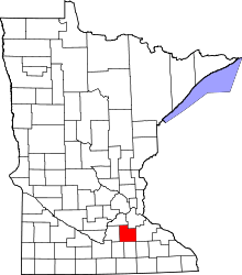 | |
| Townships | ||
| CDP | ||
| Unincorporated communities | ||
| Ghost towns/Neighborhoods | ||
| Footnotes | ‡This populated place also has portions in an adjacent county or counties | |
This article is issued from
Wikipedia.
The text is licensed under Creative Commons - Attribution - Sharealike.
Additional terms may apply for the media files.