Stearns County, Minnesota
| Stearns County, Minnesota | |
|---|---|
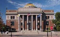 Stearns County Courthouse | |
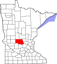 Location in the U.S. state of Minnesota | |
 Minnesota's location in the U.S. | |
| Founded | February 20, 1855[1] |
| Named for | Charles Thomas Stearns |
| Seat | St. Cloud |
| Largest city | St. Cloud |
| Area | |
| • Total | 1,390 sq mi (3,600 km2) |
| • Land | 1,343 sq mi (3,478 km2) |
| • Water | 47 sq mi (122 km2), 3.4% |
| Population (est.) | |
| • (2016) | 155,652 |
| • Density | 112/sq mi (43/km2) |
| Congressional districts | 6th, 7th |
| Time zone | Central: UTC−6/−5 |
| Website |
www |
Stearns County is a county located in the U.S. state of Minnesota. As of the 2010 census, the population was 150,642.[2] Its county seat is Saint Cloud.[3] The county was founded in 1855. It was originally named after Isaac Ingalls Stevens, later changed to the name Stearns, after Charles Thomas Stearns.
Stearns County is part of the St. Cloud, MN Metropolitan Statistical Area, which is also included in the Minneapolis-St. Paul, MN-WI Combined Statistical Area.
History
The area that is currently Stearns County was formerly occupied by numerous indigenous tribes, such as the Sioux (Dakota), Chippewa (Ojibwe) and Winnebago (Ho-chunk). The first large immigration was of German Catholics in the 1850s. Early arrivals also came from eastern states. Originally, the county was supposed to be named Stevens County after Governor Isaac Ingalls Stevens who conducted an area expedition in 1853. However, due to a clerical error, the county was named Stearns after Charles Thomas Stearns who was a member of the Territorial Council. (Later, the area two counties west was named Stevens County, to compensate for this clerical error.)
Geography

According to the U.S. Census Bureau, the county has a total area of 1,390 square miles (3,600 km2), of which 1,343 square miles (3,480 km2) is land and 47 square miles (120 km2) (3.4%) is water.[5]
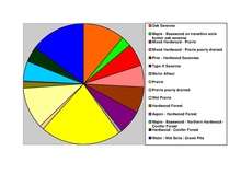
The eastern border of Stearns County is the Mississippi River. The land consists of rolling hills, scenic lakes, prairies, savannas and woodlands of a mixture of coniferous and deciduous trees. Stearns is one of 17 Minnesota savanna region counties with more savanna soils than either prairie or forest soils. There are 166 lakes in Stearns County.
Major highways


- List of county roads
Adjacent counties
- Todd County (north)
- Morrison County (north)
- Benton County (east)
- Sherburne County (east)
- Wright County (southeast)
- Meeker County (south)
- Kandiyohi County (south)
- Pope County (west)
- Douglas County (northwest)

Demographics
| Historical population | |||
|---|---|---|---|
| Census | Pop. | %± | |
| 1860 | 4,505 | — | |
| 1870 | 14,206 | 215.3% | |
| 1880 | 21,956 | 54.6% | |
| 1890 | 34,844 | 58.7% | |
| 1900 | 44,464 | 27.6% | |
| 1910 | 47,733 | 7.4% | |
| 1920 | 55,741 | 16.8% | |
| 1930 | 62,121 | 11.4% | |
| 1940 | 67,200 | 8.2% | |
| 1950 | 70,681 | 5.2% | |
| 1960 | 80,345 | 13.7% | |
| 1970 | 95,400 | 18.7% | |
| 1980 | 108,161 | 13.4% | |
| 1990 | 118,791 | 9.8% | |
| 2000 | 133,166 | 12.1% | |
| 2010 | 150,642 | 13.1% | |
| Est. 2016 | 155,652 | [6] | 3.3% |
| U.S. Decennial Census[7] 1790-1960[8] 1900-1990[9] 1990-2000[10] 2010-2016[2] | |||
As of the 2000 census, there were 133,166 people, 47,604 households, and 32,132 families residing in the county. The population density was 99 people per square mile (38/km²). There were 50,291 housing units at an average density of 37 per square mile (14/km²). The racial makeup of the county was 95.99% White, 0.83% Black or African American, 0.26% Native American, 1.58% Asian, 0.03% Pacific Islander, 0.47% from other races, and 0.82% from two or more races. 1.37% of the population were Hispanic or Latino of any race. 56.9% were of German and 9.4% Norwegian ancestry.
There were 47,604 households out of which 35.00% had children under the age of 18 living with them, 56.30% were married couples living together, 7.50% had a female householder with no husband present, and 32.50% were non-families. 23.60% of all households were made up of individuals and 8.40% had someone living alone who was 65 years of age or older. The average household size was 2.64 and the average family size was 3.15.
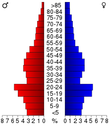
In the county, the population was spread out with 25.70% under the age of 18, 16.10% from 18 to 24, 28.00% from 25 to 44, 19.10% from 45 to 64, and 11.00% who were 65 years of age or older. The median age was 32 years. For every 100 females, there were 101.20 males. For every 100 females age 18 and over, there were 99.80 males.
The median income for a household in the county was $42,426, and the median income for a family was $51,553. Males had a median income of $34,268 versus $23,393 for females. The per capita income for the county was $19,211. About 4.30% of families and 8.70% of the population were below the poverty line, including 6.70% of those under age 18 and 8.60% of those age 65 or over.
Communities
Cities
- Albany
- Avon
- Belgrade
- Brooten (partial)
- Clearwater (partial)
- Cold Spring
- Eden Valley (partial)
- Elrosa
- Freeport
- Greenwald
- Holdingford
- Kimball
- Lake Henry
- Meire Grove
- Melrose
- New Munich
- Paynesville
- Richmond
- Rockville
- Roscoe
- Sartell (partial)
- Sauk Centre
- Spring Hill
- Saint Anthony
- Saint Augusta
- Saint Cloud (county seat; partial)
- Saint Joseph
- Saint Martin
- Saint Rosa
- Saint Stephen
- Waite Park
Townships
- Albany Township
- Ashley Township
- Avon Township
- Brockway Township
- Collegeville Township
- Crow Lake Township
- Crow River Township
- Eden Lake Township
- Fair Haven Township
- Farming Township
- Getty Township
- Grove Township
- Holding Township
- Krain Township
- Lake George Township
- Lake Henry Township
- Le Sauk Township
- Luxemburg Township
- Lynden Township
- Maine Prairie Township
- Melrose Township
- Millwood Township
- Munson Township
- North Fork Township
- Oak Township
- Paynesville Township
- Raymond Township
- Sauk Centre Township
- Spring Hill Township
- Saint Joseph Township
- Saint Martin Township
- Saint Wendel Township
- Wakefield Township
- Zion Township
Census-designated place
Other unincorporated communities
Politics and government
Stearns County has supported the Republicans in 9 of the last 15 presidential elections.
| Year | Republican | Democratic | Third parties |
|---|---|---|---|
| 2016 | 59.8% 47,617 | 32.1% 25,576 | 8.0% 6,399 |
| 2012 | 54.8% 43,015 | 42.8% 33,551 | 2.4% 1,911 |
| 2008 | 52.3% 41,194 | 45.3% 35,690 | 2.4% 1,872 |
| 2004 | 55.2% 41,726 | 43.2% 32,659 | 1.6% 1,192 |
| 2000 | 51.9% 32,402 | 39.7% 24,800 | 8.4% 5,274 |
| 1996 | 39.0% 21,474 | 44.0% 24,238 | 17.0% 9,333 |
| 1992 | 37.9% 22,502 | 36.2% 21,451 | 25.9% 15,387 |
| 1988 | 52.9% 27,529 | 45.7% 23,798 | 1.5% 766 |
| 1984 | 58.5% 30,216 | 40.6% 20,944 | 0.9% 485 |
| 1980 | 48.3% 24,888 | 42.4% 21,862 | 9.3% 4,772 |
| 1976 | 40.9% 19,574 | 52.3% 25,027 | 6.7% 3,220 |
| 1972 | 45.8% 18,951 | 46.7% 19,315 | 7.6% 3,134 |
| 1968 | 45.9% 15,422 | 47.6% 15,990 | 6.5% 2,168 |
| 1964 | 40.4% 13,009 | 59.3% 19,063 | 0.3% 94 |
| 1960 | 41.5% 13,522 | 58.4% 19,026 | 0.1% 33 |
| 1956 | 63.7% 17,364 | 36.1% 9,829 | 0.2% 64 |
| 1952 | 64.8% 18,267 | 35.1% 9,907 | 0.1% 39 |
| 1948 | 39.5% 10,153 | 59.4% 15,261 | 1.1% 292 |
| 1944 | 60.4% 13,298 | 39.3% 8,647 | 0.4% 84 |
| 1940 | 63.0% 16,027 | 36.6% 9,305 | 0.4% 102 |
| 1936 | 23.3% 5,262 | 56.5% 12,760 | 20.2% 4,558 |
| 1932 | 19.5% 4,499 | 79.4% 18,293 | 1.1% 258 |
| 1928 | 28.6% 6,459 | 71.2% 16,104 | 0.2% 52 |
| 1924 | 37.4% 6,469 | 7.8% 1,354 | 54.8% 9,491 |
| 1920 | 86.3% 13,566 | 10.3% 1,616 | 3.4% 532 |
| 1916 | 54.4% 4,312 | 42.3% 3,350 | 3.3% 259 |
| 1912 | 17.6% 1,134 | 51.6% 3,317 | 30.8% 1,983 |
| 1908 | 38.8% 2,614 | 56.9% 3,835 | 4.4% 296 |
| 1904 | 50.4% 2,849 | 46.5% 2,625 | 3.1% 175 |
| 1900 | 35.6% 2,460 | 61.3% 4,244 | 3.1% 216 |
| 1896 | 36.1% 2,873 | 61.6% 4,911 | 2.3% 183 |
| 1892 | 23.7% 1,624 | 65.0% 4,461 | 11.3% 774 |
See also
References
- ↑ "Minnesota Place Names". Minnesota Historical Society. Archived from the original on June 20, 2012. Retrieved March 19, 2014.
- 1 2 "State & County QuickFacts". United States Census Bureau. Retrieved September 1, 2013.
- ↑ "Find a County". National Association of Counties. Retrieved 2011-06-07.
- ↑ Nelson, Steven (2011). Savanna Soils of Minnesota. Minnesota: Self. pp. 49-52. ISBN 978-0-615-50320-2.
- ↑ "2010 Census Gazetteer Files". United States Census Bureau. August 22, 2012. Archived from the original on September 21, 2013. Retrieved October 25, 2014.
- ↑ "Population and Housing Unit Estimates". Retrieved June 9, 2017.
- ↑ "U.S. Decennial Census". United States Census Bureau. Retrieved October 25, 2014.
- ↑ "Historical Census Browser". University of Virginia Library. Retrieved October 25, 2014.
- ↑ "Population of Counties by Decennial Census: 1900 to 1990". United States Census Bureau. Retrieved October 25, 2014.
- ↑ "Census 2000 PHC-T-4. Ranking Tables for Counties: 1990 and 2000" (PDF). United States Census Bureau. Retrieved October 25, 2014.
- ↑ Leip, David. "Dave Leip's Atlas of U.S. Presidential Elections". uselectionatlas.org. Retrieved 2018-10-10.
External links
- Stearns County official website
- Sartell Historical Society - Sartell, MN
- Stearns History Museum official website
Places adjacent to Stearns County, Minnesota | ||||||||||
|---|---|---|---|---|---|---|---|---|---|---|
| ||||||||||
Municipalities and communities of Stearns County, Minnesota, United States | ||
|---|---|---|
| Cities |
| |
| Townships |
| |
| CDP | ||
| Unincorporated communities | ||
| Ghost towns/Neighborhoods | ||
| Footnotes | ‡This populated place also has portions in an adjacent county or counties | |
| Core City | 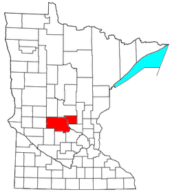 | ||||
|---|---|---|---|---|---|
| Surrounding communities |
| ||||
| Counties | |||||
‡ indicates that it is partially in the metropolitan area. § indicates a CDP | |||||