Clay County, Minnesota
| Clay County, Minnesota | |
|---|---|
 | |
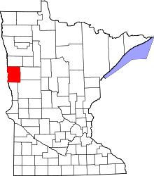 Location in the U.S. state of Minnesota | |
 Minnesota's location in the U.S. | |
| Founded |
March 8, 1862 (created) 1872 (organized)[1] |
| Named for | Henry Clay |
| Seat | Moorhead |
| Largest city | Moorhead |
| Area | |
| • Total | 1,053 sq mi (2,727 km2) |
| • Land | 1,045 sq mi (2,707 km2) |
| • Water | 7.3 sq mi (19 km2), 0.7% |
| Population (est.) | |
| • (2017) | 63,569[2] |
| • Density | 61/sq mi (24/km2) |
| Congressional district | 7th |
| Time zone | Central: UTC−6/−5 |
| Website |
www |
Clay County is a county located in the U.S. state of Minnesota. As of the 2010 census, the population was 58,999.[3] Its county seat is Moorhead.[4] The county's name is in honor of American statesman Henry Clay,[5] member of the United States Senate from Kentucky and United States Secretary of State in the 19th century. The county was formed in 1862 and organized in 1872.[6] It was originally called Breckenridge County, but changed to its current name in 1862.
Clay County is part of the Fargo, ND-MN Metropolitan Statistical Area.
Geography
According to the U.S. Census Bureau, the county has a total area of 1,053 square miles (2,730 km2), of which 1,045 square miles (2,710 km2) are land and 7.3 square miles (19 km2) (0.7%) are covered by water.[7]
Major highways
Adjacent counties
- Norman County (north)
- Becker County (east)
- Otter Tail County (southeast)
- Wilkin County (south)
- Richland County, North Dakota (southwest)
- Cass County, North Dakota (west)
Climate and weather
| Moorhead, Minnesota | ||||||||||||||||||||||||||||||||||||||||||||||||||||||||||||
|---|---|---|---|---|---|---|---|---|---|---|---|---|---|---|---|---|---|---|---|---|---|---|---|---|---|---|---|---|---|---|---|---|---|---|---|---|---|---|---|---|---|---|---|---|---|---|---|---|---|---|---|---|---|---|---|---|---|---|---|---|
| Climate chart (explanation) | ||||||||||||||||||||||||||||||||||||||||||||||||||||||||||||
| ||||||||||||||||||||||||||||||||||||||||||||||||||||||||||||
| ||||||||||||||||||||||||||||||||||||||||||||||||||||||||||||
In recent years, average temperatures in the county seat of Moorhead have ranged from a low of 0 °F (−18 °C) in January to a high of 82 °F (28 °C) in July, although a record low of −48 °F (−44 °C) was recorded in January 1887 and a record high of 114 °F (46 °C) was recorded in July 1936. Average monthly precipitation ranged from 0.64 inches (16 mm) in February to 3.90 inches (99 mm) in June.[9]
Demographics
| Historical population | |||
|---|---|---|---|
| Census | Pop. | %± | |
| 1860 | 72 | — | |
| 1870 | 92 | 27.8% | |
| 1880 | 5,887 | 6,298.9% | |
| 1890 | 11,517 | 95.6% | |
| 1900 | 17,942 | 55.8% | |
| 1910 | 19,640 | 9.5% | |
| 1920 | 21,780 | 10.9% | |
| 1930 | 23,120 | 6.2% | |
| 1940 | 25,337 | 9.6% | |
| 1950 | 30,363 | 19.8% | |
| 1960 | 39,080 | 28.7% | |
| 1970 | 46,585 | 19.2% | |
| 1980 | 49,327 | 5.9% | |
| 1990 | 50,422 | 2.2% | |
| 2000 | 51,229 | 1.6% | |
| 2010 | 58,999 | 15.2% | |
| Est. 2017 | 63,569 | [10] | 7.7% |
| U.S. Decennial Census[11] 1790-1960[12] 1900-1990[13] 1990-2000[14] 2010-2016[3] | |||
As of the 2000 census, there were 51,229 people, 18,670 households, and 12,340 families residing in the county. The population density was 49 people per square mile (19/km²). There were 19,746 housing units at an average density of 19 per square mile (7/km²). The racial makeup of the county was 93.99% White, 0.52% Black or African American, 1.44% Native American, 0.88% Asian, 0.03% Pacific Islander, 1.67% from other races, and 1.47% from two or more races. 3.65% of the population were Hispanic or Latino of any race. 40.4% were of Norwegian and 26.8% German ancestry.
There were 18,670 households out of which 33.80% had children under the age of 18 living with them, 53.90% were married couples living together, 8.80% had a female householder with no husband present, and 33.90% were non-families. 26.10% of all households were made up of individuals and 10.60% had someone living alone who was 65 years of age or older. The average household size was 2.53 and the average family size was 3.07.
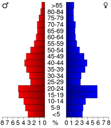
In the county, the population was spread out with 25.00% under the age of 18, 17.10% from 18 to 24, 25.70% from 25 to 44, 19.30% from 45 to 64, and 12.90% who were 65 years of age or older. The median age was 32 years. For every 100 females, there were 93.70 males. For every 100 females age 18 and over, there were 89.10 males.
The median income for a household in the county was $37,889, and the median income for a family was $49,192. Males had a median income of $34,176 versus $23,149 for females. The per capita income for the county was $17,557. About 7.40% of families and 13.20% of the population were below the poverty line, including 13.30% of those under age 18 and 7.50% of those age 65 or over.
Law and government
Clay County is governed by a board of five commissioners.[15]
- Jim Haney (Moorhead) 1st District
- Frank Gross (Dilworth) 2nd District
- Jenny L. Mongeau (Moorhead) 3rd District (Vice Chair)
- Kevin Campbell (Moorhead) 4th District (Chair)
- Grant Weyland (Moorhead) 5th District
| Year | Republican | Democratic | Third parties |
|---|---|---|---|
| 2016 | 46.1% 13,543 | 44.1% 12,971 | 9.8% 2,884 |
| 2012 | 44.7% 12,920 | 52.7% 15,208 | 2.6% 758 |
| 2008 | 40.9% 11,978 | 57.0% 16,666 | 2.1% 615 |
| 2004 | 51.8% 14,365 | 46.8% 12,989 | 1.4% 383 |
| 2000 | 50.1% 11,712 | 43.4% 10,128 | 6.5% 1,518 |
| 1996 | 41.1% 8,764 | 49.1% 10,476 | 9.8% 2,079 |
| 1992 | 41.2% 9,666 | 41.9% 9,845 | 16.9% 3,967 |
| 1988 | 47.8% 10,380 | 51.5% 11,186 | 0.6% 139 |
| 1984 | 52.6% 11,565 | 46.8% 10,294 | 0.5% 119 |
| 1980 | 46.4% 10,447 | 39.7% 8,940 | 13.9% 3,121 |
| 1976 | 47.5% 10,317 | 50.1% 10,876 | 2.4% 515 |
| 1972 | 54.4% 11,089 | 44.5% 9,076 | 1.2% 235 |
| 1968 | 47.8% 7,910 | 48.2% 7,987 | 4.0% 663 |
| 1964 | 37.4% 6,085 | 62.4% 10,161 | 0.2% 39 |
| 1960 | 53.3% 8,278 | 46.6% 7,241 | 0.2% 25 |
| 1956 | 52.8% 6,783 | 47.1% 6,057 | 0.1% 15 |
| 1952 | 58.7% 7,178 | 41.2% 5,036 | 0.2% 20 |
| 1948 | 38.6% 4,302 | 59.4% 6,624 | 2.0% 219 |
| 1944 | 45.4% 4,392 | 54.1% 5,230 | 0.5% 52 |
| 1940 | 41.2% 4,450 | 58.3% 6,295 | 0.4% 48 |
| 1936 | 29.9% 2,880 | 65.3% 6,282 | 4.8% 459 |
| 1932 | 29.2% 2,556 | 67.8% 5,938 | 3.1% 270 |
| 1928 | 61.1% 5,057 | 37.8% 3,128 | 1.1% 87 |
| 1924 | 44.6% 3,081 | 6.4% 439 | 49.1% 3,396 |
| 1920 | 73.0% 4,943 | 19.7% 1,335 | 7.3% 493 |
| 1916 | 44.8% 1,549 | 49.6% 1,716 | 5.6% 193 |
| 1912 | 18.0% 549 | 30.9% 942 | 51.2% 1,561 |
| 1908 | 58.7% 1,857 | 35.6% 1,125 | 5.8% 182 |
| 1904 | 78.2% 2,185 | 13.9% 388 | 8.0% 223 |
| 1900 | 59.5% 1,903 | 36.4% 1,165 | 4.2% 133 |
| 1896 | 44.4% 1,594 | 53.1% 1,908 | 2.5% 90 |
| 1892 | 40.2% 959 | 24.9% 594 | 34.9% 833 |
Communities
Cities
Townships
- Alliance Township
- Barnesville Township
- Cromwell Township
- Eglon Township
- Elkton Township
- Elmwood Township
- Felton Township
- Flowing Township
- Georgetown Township
- Glyndon Township
- Goose Prairie Township
- Hagen Township
- Hawley Township
- Highland Grove Township
- Holy Cross Township
- Humboldt Township
- Keene Township
- Kragnes Township
- Kurtz Township
- Moland Township
- Moorhead Township
- Morken Township
- Oakport Township
- Parke Township
- Riverton Township
- Skree Township
- Spring Prairie Township
- Tansem Township
- Ulen Township
- Viding Township
Census-designated places
Other unincorporated communities
See also
References
- ↑ "Minnesota Place Names". Minnesota Historical Society. Retrieved March 17, 2014.
- ↑ "QuickFacts. Clay County, Minnesota". Census.gov. Retrieved June 28, 2018.
- 1 2 "State & County QuickFacts". United States Census Bureau. Retrieved August 31, 2013.
- ↑ "Find a County". National Association of Counties. Archived from the original on 2011-05-31. Retrieved 2011-06-07.
- ↑ Gannett, Henry (1905). The Origin of Certain Place Names in the United States. Govt. Print. Off. p. 83.
- ↑ Upham, Warren (1920). Minnesota Geographic Names: Their Origin and Historic Significance. Minnesota Historical Society. p. 114.
- ↑ "2010 Census Gazetteer Files". United States Census Bureau. August 22, 2012. Archived from the original on October 6, 2014. Retrieved October 6, 2014.
- ↑ Nelson, Steven (2011). Savanna Soils of Minnesota. Minnesota: Self. pp. 57-60. ISBN 978-0-615-50320-2.
- 1 2 "Monthly Averages for Moorhead, Minnesota". The Weather Channel. Retrieved 2011-11-06.
- ↑ "Population and Housing Unit Estimates". Retrieved June 9, 2017.
- ↑ "U.S. Decennial Census". United States Census Bureau. Archived from the original on May 12, 2015. Retrieved October 6, 2014.
- ↑ "Historical Census Browser". University of Virginia Library. Retrieved October 6, 2014.
- ↑ "Population of Counties by Decennial Census: 1900 to 1990". United States Census Bureau. Retrieved October 6, 2014.
- ↑ "Census 2000 PHC-T-4. Ranking Tables for Counties: 1990 and 2000" (PDF). United States Census Bureau. Retrieved October 6, 2014.
- ↑ "Board of Commissioners | Clay County, MN - Official Website". claycountymn.gov. Retrieved 2018-04-17.
- ↑ Leip, David. "Dave Leip's Atlas of U.S. Presidential Elections". uselectionatlas.org. Retrieved 2018-04-17.
External links
| Wikimedia Commons has media related to Clay County, Minnesota. |
Places adjacent to Clay County, Minnesota | ||||||||||
|---|---|---|---|---|---|---|---|---|---|---|
| ||||||||||
Municipalities and communities of Clay County, Minnesota, United States | ||
|---|---|---|
| Cities | | |
| Townships | ||
| CDPs | ||
| Unincorporated communities | ||
| Ghost towns | ||
| Counties | ||
|---|---|---|
| Main cities | ||
| Surrounding areas |
| |
‡ - county seat | ||