Millersburg, Minnesota
| Millersburg, Minnesota | |
|---|---|
| Unincorporated community | |
 Millersburg, Minnesota Location of the community of Millersburg within Forest Township, Rice County  Millersburg, Minnesota Millersburg, Minnesota (the US) | |
| Coordinates: 44°25′40″N 93°19′55″W / 44.42778°N 93.33194°WCoordinates: 44°25′40″N 93°19′55″W / 44.42778°N 93.33194°W | |
| Country | United States |
| State | Minnesota |
| County | Rice County |
| Township | Forest Township |
| Elevation | 1,076 ft (328 m) |
| Time zone | UTC-6 (Central (CST)) |
| • Summer (DST) | UTC-5 (CDT) |
| ZIP code | 55046 |
| Area code(s) | 507 |
| GNIS feature ID | 654828[1] |
Millersburg is an unincorporated community in Forest Township, Rice County, Minnesota, United States.
The community is located along Rice County Road 1 (Millersburg Boulevard) near its junction with Chester Avenue. Nearby places include Lonsdale, Faribault, Northfield, and Dundas.
ZIP codes 55046 (Lonsdale), 55021 (Faribault), 55057 (Northfield), and 55019 (Dundas) all meet near Millersburg.
Millersburg was laid out in 1857 by George W. Miller, and named for him.[2]
References
- ↑ "Millersburg, Minnesota". Geographic Names Information System. United States Geological Survey.
- ↑ Upham, Warren (1920). Minnesota Geographic Names: Their Origin and Historic Significance. Minnesota Historical Society. p. 462.
Municipalities and communities of Rice County, Minnesota, United States | ||
|---|---|---|
| Cities | 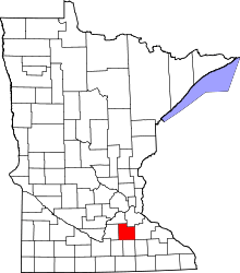 | |
| Townships | ||
| CDP | ||
| Unincorporated communities | ||
| Ghost towns/Neighborhoods | ||
| Footnotes | ‡This populated place also has portions in an adjacent county or counties | |
This article is issued from
Wikipedia.
The text is licensed under Creative Commons - Attribution - Sharealike.
Additional terms may apply for the media files.