Warsaw, Minnesota
| Warsaw, Minnesota | |
|---|---|
| Census-designated place (CDP) and Unincorporated community | |
 | |
 Warsaw, Minnesota Location of the community of Warsaw within Warsaw Township, Rice County | |
| Coordinates: 44°14′58″N 93°23′38″W / 44.24944°N 93.39389°WCoordinates: 44°14′58″N 93°23′38″W / 44.24944°N 93.39389°W | |
| Country | United States |
| State | Minnesota |
| County | Rice County |
| Township | Warsaw Township |
| Area[1] | |
| • Total | 0.855 sq mi (2.21 km2) |
| • Land | 0.846 sq mi (2.19 km2) |
| • Water | 0.009 sq mi (0.02 km2) |
| Elevation | 1,001 ft (305 m) |
| Population (2010)[2] | |
| • Total | 627 |
| • Density | 730/sq mi (280/km2) |
| Time zone | UTC-6 (Central (CST)) |
| • Summer (DST) | UTC-5 (CDT) |
| ZIP code | 55087 |
| Area code(s) | 507 |
| GNIS feature ID | 653792[3] |
Warsaw is an unincorporated community and census-designated place (CDP) in Warsaw Township, Rice County, Minnesota, United States. As of the 2010 census, its population was 627.[2]
The community is located east of Morristown and west of Faribault.
Warsaw is located at the junction of State Highway 60 (MN 60) and Rice County Road 13 (Farwell Avenue) on the west side of Cannon Lake.
The community is located within ZIP code 55087.
References
- ↑ "US Gazetteer files: 2010, 2000, and 1990". United States Census Bureau. 2011-02-12. Retrieved 2011-04-23.
- 1 2 "American FactFinder". United States Census Bureau. Retrieved 2011-05-14.
- ↑ "Warsaw, Minnesota". Geographic Names Information System. United States Geological Survey.
- Official State of Minnesota Highway Map – 2013/2014 edition
Municipalities and communities of Rice County, Minnesota, United States | ||
|---|---|---|
| Cities | 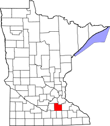 | |
| Townships | ||
| CDP | ||
| Unincorporated communities | ||
| Ghost towns/Neighborhoods | ||
| Footnotes | ‡This populated place also has portions in an adjacent county or counties | |
This article is issued from
Wikipedia.
The text is licensed under Creative Commons - Attribution - Sharealike.
Additional terms may apply for the media files.