Mower County, Minnesota
| Mower County, Minnesota | |
|---|---|
 Mower County Courthouse in Austin | |
 Location in the U.S. state of Minnesota | |
 Minnesota's location in the U.S. | |
| Founded | February 20, 1855[1] |
| Named for | John Edward Mower |
| Seat | Austin |
| Largest city | Austin |
| Area | |
| • Total | 712 sq mi (1,844 km2) |
| • Land | 711 sq mi (1,841 km2) |
| • Water | 0.2 sq mi (1 km2), 0.03% |
| Population (est.) | |
| • (2016) | 39,163 |
| • Density | 55/sq mi (21/km2) |
| Congressional district | 1st |
| Time zone | Central: UTC−6/−5 |
| Website |
www |
Mower County (/ˈmaʊ.ər/) is a county located in the U.S. state of Minnesota. As of the 2010 census, the population was 39,163.[2] The county seat is Austin.[3] The county is named after John Edward Mower.
Mower County comprises the Austin, MN Micropolitan Statistical Area and is included in the Rochester-Austin Combined Statistical Area.
Lake Louise State Park is located in the southeast part of the county near Le Roy.
History
In 1852, Jacob McQuillin and his family settled what was to become Mower County. By 1855, the area had enough people to merit official formation and on March 1, 1856 Minnesota Governor Willis A. Gorman (D) signed the act organizing Mower County. The county was named in honor of John Edward Mower, a member of the territorial legislature.
Government
| Year | Republican | Democratic | Third parties |
|---|---|---|---|
| 2016 | 49.8% 8,823 | 42.0% 7,437 | 8.2% 1,455 |
| 2012 | 37.4% 6,938 | 60.0% 11,129 | 2.6% 472 |
| 2008 | 36.9% 7,075 | 60.5% 11,605 | 2.6% 507 |
| 2004 | 37.5% 7,591 | 61.0% 12,334 | 1.5% 297 |
| 2000 | 37.2% 6,873 | 57.9% 10,693 | 5.0% 914 |
| 1996 | 27.7% 4,994 | 57.7% 10,413 | 14.7% 2,656 |
| 1992 | 25.5% 5,147 | 49.2% 9,935 | 25.4% 5,128 |
| 1988 | 36.6% 6,969 | 62.5% 11,893 | 0.9% 163 |
| 1984 | 39.0% 8,054 | 60.5% 12,498 | 0.5% 95 |
| 1980 | 38.9% 7,908 | 51.9% 10,538 | 9.3% 1,879 |
| 1976 | 38.0% 8,163 | 59.7% 12,837 | 2.3% 487 |
| 1972 | 48.4% 9,929 | 50.1% 10,286 | 1.5% 315 |
| 1968 | 39.7% 7,736 | 56.6% 11,022 | 3.7% 728 |
| 1964 | 32.3% 6,510 | 67.4% 13,573 | 0.3% 57 |
| 1960 | 52.4% 11,040 | 47.3% 9,961 | 0.3% 67 |
| 1956 | 50.7% 9,570 | 48.8% 9,219 | 0.5% 101 |
| 1952 | 53.2% 9,862 | 46.1% 8,551 | 0.7% 138 |
| 1948 | 37.1% 5,672 | 61.9% 9,468 | 1.1% 161 |
| 1944 | 47.6% 6,588 | 52.0% 7,199 | 0.4% 48 |
| 1940 | 47.1% 7,169 | 52.5% 7,988 | 0.4% 60 |
| 1936 | 35.2% 4,743 | 61.0% 8,228 | 3.8% 516 |
| 1932 | 37.8% 4,005 | 60.6% 6,421 | 1.6% 173 |
| 1928 | 63.1% 6,209 | 36.5% 3,587 | 0.5% 46 |
| 1924 | 55.7% 5,061 | 6.2% 564 | 38.1% 3,463 |
| 1920 | 82.1% 6,339 | 13.7% 1,061 | 4.2% 325 |
| 1916 | 59.4% 2,520 | 37.1% 1,572 | 3.5% 148 |
| 1912 | 31.6% 1,321 | 29.4% 1,228 | 39.0% 1,628 |
| 1908 | 63.5% 2,629 | 29.1% 1,206 | 7.4% 308 |
| 1904 | 77.5% 2,769 | 15.5% 552 | 7.1% 252 |
| 1900 | 70.8% 3,076 | 24.9% 1,081 | 4.4% 191 |
| 1896 | 68.8% 3,379 | 28.7% 1,407 | 2.5% 123 |
| 1892 | 56.4% 2,234 | 33.1% 1,310 | 10.6% 420 |
Five people are elected as Mower County Commissioners, serving staggered four year terms. Commissioners work to provide services to people and communities while overseeing the cost of such services. The Mower County Board meets the first, second, and fourth Tuesday each month in the Board Room located in the Lower Level of the Mower County Courthouse. The first meeting of the month begins at 1:00 PM while the remaining begin with departmental business at 8:30 AM with general business starting around 10:00 AM.
- First District- Cities: Brownsdale, Mapleview, Waltham and the 1st Ward, 1st Precinct of Austin
- Townships: Lansing Township, Red Rock Township, Udolpho Township, Waltham Township
- Commissioner: Tim Gabrielson
- Townships: Lansing Township, Red Rock Township, Udolpho Township, Waltham Township
- Second District- Cities: Adams, Dexter, Elkton, Grand Meadow, Le Roy, Racine, Sargeant, Taopi
- Townships: Adams Township, Bennington Township, Clayton Township, Dexter Township, Frankford Township, Grand Meadow Township, Le Roy Township, Lodi Township, Marshall Township, Pleasant Valley Township, Racine Township, Sargeant Township
- Commissioner:Raymond Tucker
- Townships: Adams Township, Bennington Township, Clayton Township, Dexter Township, Frankford Township, Grand Meadow Township, Le Roy Township, Lodi Township, Marshall Township, Pleasant Valley Township, Racine Township, Sargeant Township
- Third District- Cities: Lyle, Rose Creek and the 2nd Ward, 2nd Precinct of the City of Austin.
- Townships: Austin, Lyle, Nevada and Windom.
- Commissioner: Jerry Reinartz
- Townships: Austin, Lyle, Nevada and Windom.
- Fourth District - The 4th District includes all of the 3rd ward of the city of Austin.
- Commissioner:Tony Bennett
- Fifth District - The 5th District includes the 1st Ward, 2nd Precinct and the 2nd Ward 1st Princt of the City of Austin.
- Commissioner: Mike Ankeny
Geography
According to the U.S. Census Bureau, the county has a total area of 712 square miles (1,840 km2), of which 711 square miles (1,840 km2) is land and 0.2 square miles (0.52 km2) (0.03%) is water.[6]
Lakes
Despite Mower County being one of only four counties in Minnesota without any natural lakes (the other three being Olmsted, Pipestone, and Rock), it does have four small ponds and lakes created by dams.
- East Side Lake: in the northeast quadrant of Austin
- Lake Louise: in Lake Louise State Park near Le Roy
- Mill Pond: in downtown Austin near the Hormel plant
- Ramsey Mill Pond: in Ramsey Golf Course, near the unincorporated settlement of Ramsey
The Cedar River (sometimes called the Red Cedar River) flows south into the county from its source in Dodge County and continues all the way through the county into Mitchell County, Iowa. It flows through Mower County's four westernmost townships: Udolpho, Lansing, Austin, and Lyle.
Major highways
Adjacent counties
- Dodge County (north)
- Olmsted County (northeast)
- Fillmore County (east)
- Howard County, Iowa (southeast)
- Mitchell County, Iowa (south)
- Worth County, Iowa (southwest)
- Freeborn County (west)
Demographics
| Historical population | |||
|---|---|---|---|
| Census | Pop. | %± | |
| 1860 | 3,217 | — | |
| 1870 | 10,447 | 224.7% | |
| 1880 | 16,799 | 60.8% | |
| 1890 | 18,019 | 7.3% | |
| 1900 | 22,335 | 24.0% | |
| 1910 | 22,640 | 1.4% | |
| 1920 | 25,993 | 14.8% | |
| 1930 | 28,065 | 8.0% | |
| 1940 | 36,113 | 28.7% | |
| 1950 | 42,277 | 17.1% | |
| 1960 | 48,498 | 14.7% | |
| 1970 | 44,919 | −7.4% | |
| 1980 | 40,390 | −10.1% | |
| 1990 | 37,385 | −7.4% | |
| 2000 | 38,603 | 3.3% | |
| 2010 | 39,163 | 1.5% | |
| Est. 2016 | 39,163 | [7] | 0.0% |
| U.S. Decennial Census[8] 1790-1960[9] 1900-1990[10] 1990-2000[11] 2010-2016[2] | |||
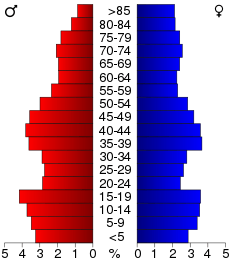
As of the 2000 census,[12] there were 38,603 people, 15,582 households, and 10,315 families residing in the county. The population density was 54 people per square mile (21/km²). There were 16,251 housing units at an average density of 23 per square mile (9/km²). The racial makeup of the county was 94.7% White, 0.6% Black or African American, 0.2% Native American, 1.5% Asian, <0.1% Pacific Islander, 2.2% from other races, and 0.9% from two or more races. 4.3% of the population were Hispanic or Latino of any race. 35.9% were of German, 24.4% Norwegian and 7.0% Irish ancestry.
There were 15,582 households out of which 29.70% had children under the age of 18 living with them, 54.70% were married couples living together, 8.00% had a female householder with no husband present, and 33.80% were non-families. 29.10% of all households were made up of individuals and 14.80% had someone living alone who was 65 years of age or older. The average household size was 2.42 and the average family size was 2.98.
In the county, the population was spread out with 25.1% under the age of 18, 8.2% from 18 to 24, 25.7% from 25 to 44, 21.4% from 45 to 64, and 19.6% who were 65 years of age or older. The median age was 39 years. For every 100 females there were 97.00 males. For every 100 females age 18 and over, there were 93.60 males.
The median income for a household in the county was $36,654, and the median income for a family was $45,154. Males had a median income of $31,743 versus $23,317 for females. The per capita income for the county was $19,795. About 6.3% of families and 9.2% of the population were below the poverty line, including 11.3% of those under age 18 and 5.6% of those age 65 or over.
Communities
Cities
- Adams
- Austin (county seat)
- Brownsdale
- Dexter
- Elkton
- Grand Meadow
- Le Roy
- Lyle
- Mapleview
- Racine
- Rose Creek
- Sargeant
- Taopi
- Waltham
Townships
All of Mower County's land is divided into 20 townships that are 36 square miles (six miles north to south X six miles (10 km) west to east) in area. Mower County is five townships wide (a total of 30 miles (48 km) west to east) and four townships from north to south (a total of 24 miles).
Census-designated place
Other unincorporated communities
See also
References
- ↑ "Minnesota Place Names". Minnesota Historical Society. Retrieved March 18, 2014.
- 1 2 "State & County QuickFacts". United States Census Bureau. Archived from the original on July 15, 2011. Retrieved September 1, 2013.
- ↑ "Find a County". National Association of Counties. Retrieved 2011-06-07.
- ↑ Leip, David. "Dave Leip's Atlas of U.S. Presidential Elections". uselectionatlas.org. Retrieved 2018-10-10.
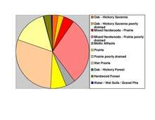
- ↑ Nelson, Steven (2011). Savanna Soils of Minnesota. Minnesota: Self. pp. 43 - 48. ISBN 978-0-615-50320-2.
- ↑ "2010 Census Gazetteer Files". United States Census Bureau. August 22, 2012. Archived from the original on September 21, 2013. Retrieved October 21, 2014.
- ↑ "Population and Housing Unit Estimates". Retrieved June 9, 2017.
- ↑ "U.S. Decennial Census". United States Census Bureau. Retrieved October 21, 2014.
- ↑ "Historical Census Browser". University of Virginia Library. Retrieved October 21, 2014.
- ↑ "Population of Counties by Decennial Census: 1900 to 1990". United States Census Bureau. Retrieved October 21, 2014.
- ↑ "Census 2000 PHC-T-4. Ranking Tables for Counties: 1990 and 2000" (PDF). United States Census Bureau. Retrieved October 21, 2014.
- ↑ "American FactFinder". United States Census Bureau. Retrieved 2008-01-31.
Further reading
- History Committee (Mower County,Minn.) (1984). Mill on the willow: a history of Mower County, Minnesota. [Mower County, Minn]: [History Committee].
External links
Places adjacent to Mower County, Minnesota | ||||||||||
|---|---|---|---|---|---|---|---|---|---|---|
| ||||||||||
Municipalities and communities of Mower County, Minnesota, United States | ||
|---|---|---|
| Cities | | |
| Townships | ||
| CDP | ||
| Unincorporated communities | ||
| Footnotes | ‡This populated place also has portions in adjacent county or counties | |