Pleasant Grove, Alamance County, North Carolina
| Pleasant Grove, North Carolina | |
|---|---|
| Unincorporated community | |
 Location of Pleasant Grove in North Carolina  Pleasant Grove, Alamance County, North Carolina (the US) | |
| Coordinates: 36°11′31″N 79°19′36″W / 36.19194°N 79.32667°WCoordinates: 36°11′31″N 79°19′36″W / 36.19194°N 79.32667°W | |
| Country | United States |
| State | North Carolina |
| County | Alamance |
| Elevation[1] | 653 ft (199 m) |
| Time zone | UTC-5 (Eastern (EST)) |
| • Summer (DST) | UTC-4 (EDT) |
| Area code(s) | 919 |
| GNIS feature ID | 992457[1] |
Pleasant Grove is an unincorporated community in Alamance County, North Carolina, United States.
Pleasant Grove is located at the intersection of North Carolina Highway 49 and North Carolina Highway 62 in the northeastern part of Alamance County. It is the site of the tribal grounds of the Occaneechi Band of the Saponi Nation.
Notable residents
- JamesOn Curry - NBA Player for the Chicago Bulls (2007–08)
References
- 1 2 U.S. Geological Survey Geographic Names Information System: Pleasant Grove, North Carolina. Retrieved on 2009-12-03.
External links

Municipalities and communities of Alamance County, North Carolina, United States | ||
|---|---|---|
| Cities | 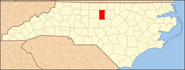 | |
| Towns | ||
| Village | ||
| CDPs | ||
| Unincorporated communities |
| |
| Footnotes | ‡This populated place also has portions in an adjacent county or counties | |
This article is issued from
Wikipedia.
The text is licensed under Creative Commons - Attribution - Sharealike.
Additional terms may apply for the media files.