Mandale, North Carolina
| Mandale, North Carolina | |
|---|---|
| Unincorporated community | |
 Location of Mandale in North Carolina  Mandale, North Carolina (the US) | |
| Coordinates: 35°51′12″N 79°16′23″W / 35.85333°N 79.27306°WCoordinates: 35°51′12″N 79°16′23″W / 35.85333°N 79.27306°W | |
| Country | United States |
| State | North Carolina |
| County | Alamance |
| Government | |
| • Mayor | Nick Mshar |
| Elevation[1] | 554 ft (169 m) |
| Time zone | UTC-5 (Eastern (EST)) |
| • Summer (DST) | UTC-4 (EDT) |
| Area code(s) | 336 |
| GNIS feature ID | 1006286[1] |
Mandale is an unincorporated community in Alamance County, North Carolina, United States.
Mandale is located on North Carolina Highway 87, south of Eli Whitney, and northwest of Pittsboro. It is about 243 miles (391 km) from Washington D.C.
References
- 1 2 "Mandale, North Carolina". Geographic Names Information System. United States Geological Survey. . Retrieved on 2008-03-29.
Municipalities and communities of Alamance County, North Carolina, United States | ||
|---|---|---|
| Cities | 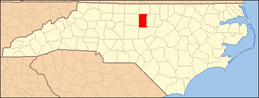 | |
| Towns | ||
| Village | ||
| CDPs | ||
| Unincorporated communities |
| |
| Footnotes | ‡This populated place also has portions in an adjacent county or counties | |
This article is issued from
Wikipedia.
The text is licensed under Creative Commons - Attribution - Sharealike.
Additional terms may apply for the media files.