Patterson, Kansas
| Patterson, Kansas | |
|---|---|
| Unincorporated Community | |
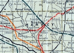 1915 Railroad Map of Harvey County | |
| Coordinates: 37°56′36″N 97°39′18″W / 37.94333°N 97.65500°WCoordinates: 37°56′36″N 97°39′18″W / 37.94333°N 97.65500°W[1] | |
| Country | United States |
| State | Kansas |
| County | Harvey |
| Elevation[1] | 1,437 ft (438 m) |
| Time zone | UTC-6 (CST) |
| • Summer (DST) | UTC-5 (CDT) |
| Area code | 620 |
| FIPS code | 20-54725 [1] |
| GNIS ID | 484647 [1] |


Patterson is an unincorporated community in Harvey County, Kansas, United States.[1] The community is located along a railroad line between Burrton and Bentley, but the track was removed in the 1990s or 2000s.[2]
History
Patterson was named for James Patterson, an early settler in Lake Township, Harvey County, Kansas. L.A. Hamlin "surveyed and laid out" the Patterson town site September 25, 1888, on land owned by Dr. Thomas S. Hunt (1830-1900) and Susan Barbee Hunt (1841-1920).[3]In 1887, Dr. Hunt deeded land for right-of-way to the Kansas Midland Railroad Company. He developed the town and sold building lots. Patterson became a station on a railroad segment of St. Louis–San Francisco Railway that ran from Wichita to Burrton. Two passenger trains a day passed through Patterson.
A post office was opened in Patterson in 1888, and remained in operation until it was discontinued in 1927.[4]
References
- 1 2 3 4 5 Geographic Names Information System (GNIS) details for Patterson, Kansas; United States Geological Survey (USGS); October 13, 1978.
- ↑ Abandoned Railroad; abandonedrails.com
- ↑ As recorded by the hand of Dr. Thomas S. Hunt in his ledger.
- ↑ "Kansas Post Offices, 1828-1961 (archived)". Kansas Historical Society. Archived from the original on October 9, 2013. Retrieved 11 June 2014.
Further reading
External links
Municipalities and communities of Harvey County, Kansas, United States | ||
|---|---|---|
| Cities | 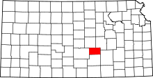 | |
| Townships | ||
| Unincorporated communities | ||
| Ghost town | ||
| Footnotes | ‡This populated place also has portions in an adjacent county or counties | |
