Zimmerdale, Kansas
| Zimmerdale, Kansas | |
|---|---|
| Unincorporated Community | |
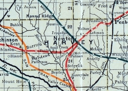 1915 Railroad Map of Harvey County | |
| Coordinates: 38°6′10″N 97°23′24″W / 38.10278°N 97.39000°WCoordinates: 38°6′10″N 97°23′24″W / 38.10278°N 97.39000°W[1] | |
| Country | United States |
| State | Kansas |
| County | Harvey |
| Elevation[1] | 1,467 ft (447 m) |
| Time zone | UTC-6 (CST) |
| • Summer (DST) | UTC-5 (CDT) |
| Area code | 620 |
| FIPS code | 20-80975 [1] |
| GNIS ID | 477994 [1] |


Zimmerdale is an unincorporated community in Harvey County, Kansas, United States.[1] Originally it was named Trousdale. The community is located along a railroad line between Hesston and Newton.
History
Zimmerdale was named for Martin Zimmermann and W. Truesdale.[2]
See also
References
Further reading
External links
Municipalities and communities of Harvey County, Kansas, United States | ||
|---|---|---|
| Cities | 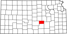 | |
| Townships | ||
| Unincorporated communities | ||
| Ghost town | ||
| Footnotes | ‡This populated place also has portions in an adjacent county or counties | |
This article is issued from
Wikipedia.
The text is licensed under Creative Commons - Attribution - Sharealike.
Additional terms may apply for the media files.