Putnam, Kansas
| Putnam, Kansas | |
|---|---|
| Unincorporated Community | |
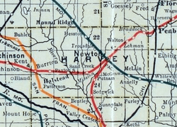 1915 Railroad Map of Harvey County | |
| Coordinates: 37°58′8″N 97°23′16″W / 37.96889°N 97.38778°WCoordinates: 37°58′8″N 97°23′16″W / 37.96889°N 97.38778°W[1] | |
| Country | United States |
| State | Kansas |
| County | Harvey |
| Elevation[1] | 1,398 ft (426 m) |
| Time zone | UTC-6 (CST) |
| • Summer (DST) | UTC-5 (CDT) |
| Area code | 620 |
| FIPS code | 20-58025 [1] |
| GNIS ID | 484649 [1] |


Putnam is an unincorporated community in Harvey County, Kansas, United States.[1]
History
Putnam had a post office from 1891 until 1907.[2]
Geography
The community is located south of Newton near SW 60th and S. West Road. It was established along a railroad line between Newton and Wichita.
References
- 1 2 3 4 5 Geographic Names Information System (GNIS) details for Putnam, Kansas; United States Geological Survey (USGS); October 13, 1978.
- ↑ "Kansas Post Offices, 1828-1961 (archived)". Kansas Historical Society. Archived from the original on October 9, 2013. Retrieved 11 June 2014.
Further reading
External links
Municipalities and communities of Harvey County, Kansas, United States | ||
|---|---|---|
| Cities | 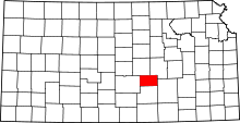 | |
| Townships | ||
| Unincorporated communities | ||
| Ghost town | ||
| Footnotes | ‡This populated place also has portions in an adjacent county or counties | |
This article is issued from
Wikipedia.
The text is licensed under Creative Commons - Attribution - Sharealike.
Additional terms may apply for the media files.