Corinth, Mississippi
| Corinth, Mississippi | |
|---|---|
| City | |
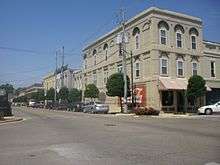
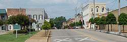 Downtown Corinth in 2010 | |
 Location of Corinth, Mississippi | |
 Corinth, Mississippi Location in the United States | |
| Coordinates: 34°56′14″N 88°30′55″W / 34.93722°N 88.51528°WCoordinates: 34°56′14″N 88°30′55″W / 34.93722°N 88.51528°W | |
| Country | United States |
| State | Mississippi |
| County | Alcorn |
| Area | |
| • Total | 30.3 sq mi (78.4 km2) |
| • Land | 30.2 sq mi (78.1 km2) |
| • Water | 0.1 sq mi (0.3 km2) |
| Elevation | 440 ft (134 m) |
| Population (2010) | |
| • Total | 14,573 |
| • Estimate (2016)[1] | 14,818 |
| • Density | 480/sq mi (190/km2) |
| Time zone | UTC−6 (Central (CST)) |
| • Summer (DST) | UTC−5 (CDT) |
| ZIP codes | 38834–38835 |
| Area code(s) | 662 |
| FIPS code | 28-15700 |
| GNIS feature ID | 0668825 |
| Website |
cityofcorinthms |
Corinth is a city in and the county seat of Alcorn County, Mississippi, United States.[2] The population was 14,573 at the 2010 census.[3] Its ZIP codes are 38834 and 38835.
History
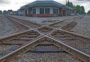
Corinth was founded in 1853 as Cross City, so-called because it served as a junction for the Mobile & Ohio and Memphis & Charleston railroads. It was the town's early newspaper editor, W. E. Gibson, who suggested the name of Corinth, named for the city in Greece that also served as a crossroads.
Corinth's location at the junction of two railroads made it strategically important to the Confederacy during the American Civil War. Confederate General P. G. T. Beauregard retreated to Corinth after the Battle of Shiloh, pursued by Union Major General Henry W. Halleck. General Beauregard abandoned the town when General Halleck approached, letting it fall into the Union's hands. Since Halleck approached so cautiously, digging entrenchments at every stop for over a month, this action has been known as the Siege of Corinth.
The Union sent Maj. Gen. William Rosecrans to Corinth as well and concentrated its forces in the city. The Second Battle of Corinth took place on October 3−4, 1862, when Confederate Maj. Gen. Earl Van Dorn attempted to retake the city.
Locales on the National Register of Historic Places
- Battery Williams (also known as Fort Williams)
- Siege and Battle of Corinth Sites
- Coliseum Theatre- built in the early 20th century in the Colonial Revival style
- Corinth National Cemetery
- Downtown Corinth Historic District
- Dr. Joseph M. Bynum House—a home in the Late Gothic Revival style built in the late 19th century
- Federal Siege Trench (also known as Harper Road Trench)
- Fort Robinette (also known as Battery Robinette)—site of the Civil War Interpretive Center
- Jacinto Courthouse (also called the Old Tishomingo County Courthouse)—built in the mid-19th century in the Federal style
- L.C. Steele House
- Midtown Corinth Historic District
- Moores Creek site—a prehistoric Native American site from 3000 to 3500 B.C.
- Old U.S. Post Office
- Rienzi Commercial Historic District
- Thomas F. Dilworth House
- Union Battery F, Battle of Corinth
- Union Earthworks
- Veranda House (also known as the Curlee House)—built in 1857, it served as headquarters for Confederate generals during the Battle of Corinth
Geography

Corinth is located in northeast Mississippi at the intersection of (north/south) U.S. Route 45 and (east/west) U.S. Route 72. It is the county seat of Alcorn County, which is the smallest county in area in the state of Mississippi. According to the United States Census Bureau, the city has a total area of 30.3 square miles (78.4 km2), of which 30.2 square miles (78.1 km2) is land and 0.12 square miles (0.3 km2), or 0.43%, is water.[5]
Communities near Corinth
Rivers and streams
- Bridge Creek
- Elam Creek
- Phillips Creek
- Turner Creek
Climate
| Climate data for Corinth, Mississippi | |||||||||||||
|---|---|---|---|---|---|---|---|---|---|---|---|---|---|
| Month | Jan | Feb | Mar | Apr | May | Jun | Jul | Aug | Sep | Oct | Nov | Dec | Year |
| Record high °F (°C) | 80 (27) |
86 (30) |
89 (32) |
94 (34) |
100 (38) |
106 (41) |
111 (44) |
110 (43) |
105 (41) |
96 (36) |
88 (31) |
80 (27) |
111 (44) |
| Average high °F (°C) | 49 (9) |
54 (12) |
63 (17) |
72 (22) |
80 (27) |
87 (31) |
90 (32) |
90 (32) |
84 (29) |
73 (23) |
62 (17) |
51 (11) |
71 (22) |
| Average low °F (°C) | 28 (−2) |
32 (0) |
39 (4) |
46 (8) |
56 (13) |
64 (18) |
68 (20) |
67 (19) |
59 (15) |
47 (8) |
38 (3) |
31 (−1) |
48 (9) |
| Record low °F (°C) | −19 (−28) |
−6 (−21) |
9 (−13) |
25 (−4) |
35 (2) |
43 (6) |
51 (11) |
49 (9) |
36 (2) |
24 (−4) |
4 (−16) |
−6 (−21) |
−19 (−28) |
| Source: The Weather Channel[6] | |||||||||||||
Demographics
| Historical population | |||
|---|---|---|---|
| Census | Pop. | %± | |
| 1870 | 1,512 | — | |
| 1880 | 2,275 | 50.5% | |
| 1890 | 2,111 | −7.2% | |
| 1900 | 3,661 | 73.4% | |
| 1910 | 5,020 | 37.1% | |
| 1920 | 5,498 | 9.5% | |
| 1930 | 6,220 | 13.1% | |
| 1940 | 7,818 | 25.7% | |
| 1950 | 9,785 | 25.2% | |
| 1960 | 11,453 | 17.0% | |
| 1970 | 11,581 | 1.1% | |
| 1980 | 13,180 | 13.8% | |
| 1990 | 11,820 | −10.3% | |
| 2000 | 14,054 | 18.9% | |
| 2010 | 14,573 | 3.7% | |
| Est. 2016 | 14,818 | [1] | 1.7% |
| U.S. Decennial Census[7] | |||
As of the census[8] of 2000, there were 14,054 people, 6,220 households, and 3,800 families residing in the city. The population density was 461.5 people per square mile (178.2/km²). There were 7,058 housing units at an average density of 231.8 per square mile (89.5/km²). The racial makeup of the city was 76.28% White, 21.60% African American, 0.09% Native American, 0.36% Asian, 0.12% Pacific Islander, 0.84% from other races, and 0.73% from two or more races. Hispanic or Latino of any race were 1.73% of the population.
There were 6,220 households out of which 26.0% had children under the age of 18 living with them, 42.9% were married couples living together, 14.8% had a female householder with no husband present, and 38.9% were non-families. Of all households, 35.6% were made up of individuals and 16.0% had someone living alone who was 65 years of age or older. The average household size was 2.19 and the average family size was 2.82.
In the city, the population was spread out with 21.8% under the age of 18, 9.3% from 18 to 24, 25.6% from 25 to 44, 23.7% from 45 to 64, and 19.6% who were 65 years of age or older. The median age was 40 years. For every 100 females, there were 85.5 males. For every 100 females age 18 and over, there were 81.0 males.
The median income for a household in the city was $23,436, and the median income for a family was $35,232. Males had a median income of $29,027 versus $21,071 for females. The per capita income for the city was $15,452. About 18.2% of families and 22.2% of the population were below the poverty line, including 26.2% of those under age 18 and 23.9% of those age 65 or over.
Education
Public schools
- Alcorn Alternative School
- Alcorn Central Elementary[10]—grades K–4, with enrollment of 520
- Alcorn Central Middle School[11]—grades 5–8 with an enrollment of 539
- Alcorn Central High School[12]—grades 9–12 with an enrollment of 515
- Biggersville Elementary—grades K–6 with an enrollment of 161
- Biggersville High School—grades 7–12 with an enrollment of 236
- Corinth High School—grades 9–12 with an enrollment of 473
- Corinth Middle School—grades 5–8 with an enrollment of 265
- Corinth Elementary School—grades K–4
- Kossuth Elementary School—grades K–4 with an enrollment of 562
- Kossuth High School—grades 9–12 with an enrollment of 438
- Kossuth Middle School—grades 5–8 with an enrollment of 499
- Easom High School (the only African American school in the city before the segregation; Became home of South Corinth Elementary School teaching 5th and 6th Grade until the 2008-2009 school year, when it became uninhabited until 2014 when a health clinic opened in the building)
Libraries
- Corinth Public Library—part of the Northeast Regional Library System
Museums
Health care
- Veranda Health Center
- Magnolia Regional Health Center
Transportation
Highways
- U.S. Route 45—runs north-south from Lake Superior to the Gulf of Mexico
- U.S. Route 72—runs east-west from Chattanooga, Tennessee to Memphis
- Mississippi Highway 2—runs southwest from the Tennessee state line to Hickory Flat
- Mississippi Highway 145
Air travel
Media
Newspapers
FM and AM radio stations
- WKCU 1350, Christian music
- WXRZ 94.3, News and Talk / Supertalk Mississippi (Mississippi political and local)
- WADI 95.3, 95.3 The Bee / Country
Notable people
- Neal Brooks Biggers, Jr., federal judge
- Don Blasingame, baseball player
- Ezekiel S. Candler, Jr., U.S. congressman
- Larry Dorsey, football coach
- Steve Gaines, pastor
- Frances Gaither, novelist
- Susie Gibson, supercentenarian
- Philip Henson, scout and spy
- Etheridge Knight, poet
- Peggy Smith Martin, Illinois state representative[17]
- Jimbo Mathus, musician
- Thomas K. McCraw, educator
- Maty Noyes, singer
- John F. Osborne, editor and journalist
- Rubel Phillips, politician
- Thomas Hal Phillips, author
- J.E. Pitts, poet and songwriter
- Saving Abel, rock band
- Everett Sharp, football player
- Jackie Simpson, professional football player.
- Orma Rinehart Smith, federal judge
- Roscoe Turner, aviator
- Jack Yarber, musician
See also
- Corinth Depot
- Johnny Vomit & The Dry Heaves - a garage band from Corinth
- Slugburger
Notes
- 1 2 "Population and Housing Unit Estimates". Retrieved June 9, 2017.
- ↑ "Find a County". National Association of Counties. Archived from the original on 2011-05-31. Retrieved 2011-06-07.
- ↑ "Corinth (city), Mississippi". U.S. Census Bureau. Archived from the original on 2016-01-20.
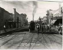
- ↑ McCord's Studio. "'Taylor Street Looking North, Oct. 1930.' Work crew repaving street". Mississippi Department of Archives and History. Archived from the original on 6 April 2012. Retrieved 2 December 2011.
- ↑ "Geographic Identifiers: 2010 Demographic Profile Data (G001): Corinth city, Mississippi". U.S. Census Bureau, American Factfinder. Retrieved June 18, 2013.
- ↑ "Monthly Averages for Corinth, MS". Retrieved 21 August 2010.
- ↑ "Census of Population and Housing". Census.gov. Archived from the original on May 12, 2015. Retrieved June 4, 2015.
- ↑ "American FactFinder". United States Census Bureau. Archived from the original on 2013-09-11. Retrieved 2008-01-31.
- ↑ "Corinth School District :: Welcome to Corinth School District". Retrieved 22 August 2015.
- ↑ "Alcorn School District ::". Retrieved 22 August 2015.
- ↑ "Alcorn School District ::". Retrieved 22 August 2015.
- ↑ "Alcorn School District ::". Retrieved 22 August 2015.
- ↑ Northeast Mississippi Museum Archived 2005-03-08 at the Wayback Machine.
- ↑ "Corinth". Retrieved 22 August 2015.
- ↑ "AirNav: KCRX - Roscoe Turner Airport". Retrieved 22 August 2015.
- ↑ "AirNav: Airport Information". Retrieved 22 August 2015.
- ↑ 'Illinois Blue Book 1977-1978,' Biographical Sketch of Peggy Smith Martin, pg. 119
References
- Brieger, James. Hometown, Mississippi. (1997). ISBN 1-886017-27-1
External links

- City of Corinth official website
|
|
- Corinth National Cemetery

Municipalities and communities of Alcorn County, Mississippi, United States | ||
|---|---|---|
| City | 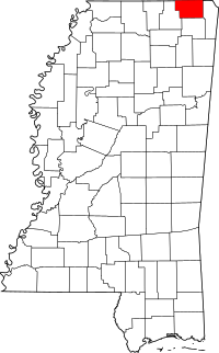 | |
| Towns | ||
| Village | ||
| Unincorporated communities | ||
| Ghost town | ||
.svg.png)