Lawrence County, Mississippi
| Lawrence County, Mississippi | |
|---|---|
 | |
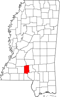 Location in the U.S. state of Mississippi | |
 Mississippi's location in the U.S. | |
| Founded | 1814 |
| Named for | James Lawrence |
| Seat | Monticello |
| Largest town | Monticello |
| Area | |
| • Total | 436 sq mi (1,129 km2) |
| • Land | 431 sq mi (1,116 km2) |
| • Water | 5.1 sq mi (13 km2), 1.2% |
| Population | |
| • (2010) | 12,929 |
| • Density | 30/sq mi (10/km2) |
| Congressional district | 3rd |
| Time zone | Central: UTC−6/−5 |
| Website |
lawrencecountyms |
Lawrence County is a county located in the U.S. state of Mississippi. As of the 2010 census, the population was 12,929.[1] Its county seat is Monticello.[2] The county is named for the naval hero James Lawrence.[3]
Geography
According to the U.S. Census Bureau, the county has a total area of 436 square miles (1,130 km2), of which 431 square miles (1,120 km2) is land and 5.1 square miles (13 km2) (1.2%) is water.[4]
Major highways


Adjacent counties
- Simpson County (northeast)
- Jefferson Davis County (east)
- Marion County (southeast)
- Walthall County (south)
- Lincoln County (west)
- Copiah County (northwest)
Demographics
| Historical population | |||
|---|---|---|---|
| Census | Pop. | %± | |
| 1820 | 4,916 | — | |
| 1830 | 5,293 | 7.7% | |
| 1840 | 5,920 | 11.8% | |
| 1850 | 6,478 | 9.4% | |
| 1860 | 9,213 | 42.2% | |
| 1870 | 6,720 | −27.1% | |
| 1880 | 9,420 | 40.2% | |
| 1890 | 12,318 | 30.8% | |
| 1900 | 15,103 | 22.6% | |
| 1910 | 13,080 | −13.4% | |
| 1920 | 12,663 | −3.2% | |
| 1930 | 12,471 | −1.5% | |
| 1940 | 13,983 | 12.1% | |
| 1950 | 12,639 | −9.6% | |
| 1960 | 10,215 | −19.2% | |
| 1970 | 11,137 | 9.0% | |
| 1980 | 12,518 | 12.4% | |
| 1990 | 12,458 | −0.5% | |
| 2000 | 13,258 | 6.4% | |
| 2010 | 12,929 | −2.5% | |
| Est. 2016 | 12,749 | [5] | −1.4% |
| U.S. Decennial Census[6] 1790-1960[7] 1900-1990[8] 1990-2000[9] 2010-2013[1] | |||
As of the census[10] of 2000, there were 13,258 people, 5,040 households, and 3,749 families residing in the county. The population density was 31 people per square mile (12/km²). There were 5,688 housing units at an average density of 13 per square mile (5/km²). The racial makeup of the county was 66.94% White, 32.07% Black or African American, 0.17% Native American, 0.27% Asian, 0.02% Pacific Islander, 0.09% from other races, and 0.44% from two or more races. 0.67% of the population were Hispanic or Latino of any race.
There were 5,040 households out of which 35.40% had children under the age of 18 living with them, 55.90% were married couples living together, 14.40% had a female householder with no husband present, and 25.60% were non-families. 24.10% of all households were made up of individuals and 11.40% had someone living alone who was 65 years of age or older. The average household size was 2.61 and the average family size was 3.10.
In the county, the population was spread out with 27.30% under the age of 18, 9.40% from 18 to 24, 27.50% from 25 to 44, 22.60% from 45 to 64, and 13.30% who were 65 years of age or older. The median age was 36 years. For every 100 females there were 92.20 males. For every 100 females age 18 and over, there were 88.30 males.
The median income for a household in the county was $28,495, and the median income for a family was $37,899. Males had a median income of $28,925 versus $18,707 for females. The per capita income for the county was $14,469. About 16.60% of families and 19.60% of the population were below the poverty line, including 26.10% of those under age 18 and 19.50% of those age 65 or over.
Communities
Towns
Unincorporated communities
- Arm
- Jayess
- Nola
- Oak Vale (partly in Jefferson Davis County)
- Oma
- Sontag
- Wanilla
Notable people
- Earl W. Bascom (1906-1995), rodeo champion, cowboy artist, inventor, Mississippi Rodeo Hall of Fame inductee,[11] "Father of Modern Rodeo"[12]
- Texas Rose Bascom (1922-1993), rodeo celebrity, Hollywood actress,[13] Mississippi Rodeo Hall of Fame inductee[14]
- Weldon Bascom (1912-1993), rodeo champion, hall of fame inductee,[15] "Father of Mississippi Rodeo"[16]
- Edgar Godbold (1872-1952), president of two Southern Baptist colleges, was a school principal in Lawrence County from 1905 to 1906.[17]
- Rod Paige, Secretary of Education from 2001-2004 under President George W. Bush. Rod Paige was born and raised in Lawrence County.[18]
Politics
| Year | Republican | Democratic | Third parties |
|---|---|---|---|
| 2016 | 64.3% 4,091 | 34.5% 2,195 | 1.2% 78 |
| 2012 | 62.6% 4,192 | 36.9% 2,468 | 0.6% 38 |
| 2008 | 62.3% 4,369 | 36.9% 2,587 | 0.8% 53 |
| 2004 | 62.7% 3,956 | 36.6% 2,308 | 0.7% 42 |
| 2000 | 55.8% 3,674 | 43.1% 2,841 | 1.1% 72 |
| 1996 | 44.5% 2,392 | 46.2% 2,481 | 9.3% 498 |
| 1992 | 44.1% 2,689 | 42.4% 2,582 | 13.5% 824 |
| 1988 | 59.2% 3,682 | 40.5% 2,517 | 0.4% 24 |
| 1984 | 63.5% 3,970 | 36.4% 2,274 | 0.1% 9 |
| 1980 | 50.0% 2,781 | 48.4% 2,692 | 1.6% 87 |
| 1976 | 47.5% 2,109 | 50.5% 2,242 | 1.9% 85 |
| 1972 | 81.7% 3,394 | 17.1% 709 | 1.2% 51 |
| 1968 | 8.5% 329 | 19.0% 740 | 72.6% 2,825 |
| 1964 | 91.0% 2,373 | 9.1% 236 | |
| 1960 | 15.7% 259 | 28.4% 469 | 55.9% 923 |
| 1956 | 18.2% 276 | 67.5% 1,025 | 14.4% 218 |
| 1952 | 33.2% 556 | 66.8% 1,117 | |
| 1948 | 1.0% 13 | 4.9% 66 | 94.1% 1,262 |
| 1944 | 2.9% 45 | 97.2% 1,535 | |
| 1940 | 3.0% 37 | 97.1% 1,218 | |
| 1936 | 2.6% 34 | 97.4% 1,286 | 0.1% 1 |
| 1932 | 3.2% 31 | 96.7% 933 | 0.1% 1 |
| 1928 | 21.7% 210 | 78.3% 759 | |
| 1924 | 7.5% 55 | 92.5% 674 | |
| 1920 | 19.9% 131 | 79.8% 526 | 0.3% 2 |
| 1916 | 2.4% 18 | 97.2% 725 | 0.4% 3 |
| 1912 | 2.4% 9 | 89.5% 332 | 8.1% 30 |
See also
References
- 1 2 "State & County QuickFacts". United States Census Bureau. Archived from the original on July 13, 2011. Retrieved September 4, 2013.
- ↑ "Find a County". National Association of Counties. Retrieved 2011-06-07.
- ↑ Gannett, Henry (1905). The Origin of Certain Place Names in the United States. U.S. Government Printing Office. p. 182.
- ↑ "2010 Census Gazetteer Files". United States Census Bureau. August 22, 2012. Archived from the original on September 28, 2013. Retrieved November 6, 2014.
- ↑ "Population and Housing Unit Estimates". Retrieved June 9, 2017.
- ↑ "U.S. Decennial Census". United States Census Bureau. Retrieved November 6, 2014.
- ↑ "Historical Census Browser". University of Virginia Library. Retrieved November 6, 2014.
- ↑ "Population of Counties by Decennial Census: 1900 to 1990". United States Census Bureau. Retrieved November 6, 2014.
- ↑ "Census 2000 PHC-T-4. Ranking Tables for Counties: 1990 and 2000" (PDF). United States Census Bureau. Retrieved November 6, 2014.
- ↑ "American FactFinder". United States Census Bureau. Retrieved 2008-01-31.
- ↑ http://www.vvdailypress.com/news/20170526/ech-work-party-spiffs-up-new-horsecamp
- ↑ https://mississippiencyclopedia.org/entries/lawrence-county/
- ↑ http://www.vvdailypress.com/news/20170526/ech-work-party-spiffs-up-new-horsecamp
- ↑ https://newsmaven.io/indiancountrytoday/archive/cherokee-choctaw-cowgirl-texas-rose-bascom-yIVB3gEIvUeuAS76qODvoQ/?mqsc=ED3885323
- ↑ http://www.prorodeohalloffame.com/inductees/pioneer-award/2016-bascoms/
- ↑ https://newsmaven.io/indiancountrytoday/archive/cherokee-choctaw-cowgirl-texas-rose-bascom-yIVB3gEIvUeuAS76qODvoQ/?mqsc=ED3885323
- ↑ "Edgar Godbold". lahistory.org. Archived from the original on November 23, 2009. Retrieved August 2, 2013.
- ↑ "Bio RodPaige.com". Retrieved December 4, 2014.
- ↑ Leip, David. "Dave Leip's Atlas of U.S. Presidential Elections". uselectionatlas.org. Retrieved 2018-03-03.
External links
Coordinates: 31°33′N 90°07′W / 31.55°N 90.11°W
Places adjacent to Lawrence County, Mississippi | ||||||||||
|---|---|---|---|---|---|---|---|---|---|---|
| ||||||||||
Municipalities and communities of Lawrence County, Mississippi, United States | ||
|---|---|---|
| Towns | | |
| Unincorporated communities | ||
| Footnotes | ‡This community also has portions in adjacent county or counties | |
.svg.png)