Stone County, Mississippi
| Stone County, Mississippi | |
|---|---|
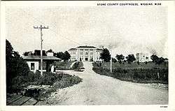
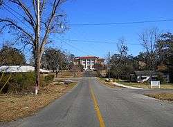
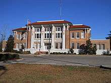 Stone County Courthouse in Wiggins | |
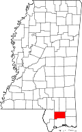 Location in the U.S. state of Mississippi | |
 Mississippi's location in the U.S. | |
| Founded | 1916 |
| Named for | John M. Stone |
| Seat | Wiggins |
| Largest city | Wiggins |
| Area | |
| • Total | 448 sq mi (1,160 km2) |
| • Land | 445 sq mi (1,153 km2) |
| • Water | 2.6 sq mi (7 km2), 0.6% |
| Population | |
| • (2010) | 17,786 |
| • Density | 40/sq mi (20/km2) |
| Congressional district | 4th |
| Time zone | Central: UTC−6/−5 |
| Website |
www |
Stone County is a county located in the U.S. state of Mississippi. As of the 2010 census, the population was 17,786.[1] Its county seat is Wiggins.[2] Stone County was formed from the northern portion of Harrison County on June 5, 1916.[3] The county was named for John M. Stone, who served as Governor of Mississippi from 1876 to 1882 and again from 1890 to 1896.
In 1918, the Stone County Courthouse was completed at a cost of $29,515.18,[4] and is still in use today, after several renovations.
Geography
According to the U.S. Census Bureau, the county has a total area of 448 square miles (1,160 km2), of which 445 square miles (1,150 km2) is land and 2.6 square miles (6.7 km2) (0.6%) is water.[5]
Major highways
Adjacent counties
- Perry County (northeast)
- George County (east)
- Jackson County (southeast)
- Harrison County (south)
- Pearl River County (west)
- Forrest County (northwest)
National protected areas
Demographics
| Historical population | |||
|---|---|---|---|
| Census | Pop. | %± | |
| 1920 | 6,528 | — | |
| 1930 | 5,704 | −12.6% | |
| 1940 | 6,155 | 7.9% | |
| 1950 | 6,264 | 1.8% | |
| 1960 | 7,013 | 12.0% | |
| 1970 | 8,101 | 15.5% | |
| 1980 | 9,716 | 19.9% | |
| 1990 | 10,750 | 10.6% | |
| 2000 | 13,622 | 26.7% | |
| 2010 | 17,786 | 30.6% | |
| Est. 2016 | 18,012 | [7] | 1.3% |
| U.S. Decennial Census[8] 1790-1960[9] 1900-1990[10] 1990-2000[11] 2010-2013[1] | |||
As of the census[12] of 2010, there were 17,786 people, 6,165 households, and 4,539 families residing in the county. The population density was 39.9 people per square mile (15.33/km²). There were 7,161 housing units at an average density of 16 per square mile (6/km²). The racial makeup of the county was 78.6% White, 19.1% Black or African American, with 2.3% being of other racial categories. 1.3% of the population were Hispanic or Latino of any race.
31.5% of households had children under the age of 18 living with them, 54.5% were married couples living together, 14.4% had a female householder with no husband present, 4.7% had a male household with no wife present, and 26.4% were non-families. 22.5% of all households were made up of individuals and 8.6% had someone living alone who was 65 years of age or older. The average household size was 2.68 and the average family size was 3.13.
24.4% were under the age of 18, 29.4% were under the age of 20, 32.3% from 20 to 44, 26.1% from 45 to 64, and 11.9% were 65 years of age or older. The median age was 35.9 years. 50.1% of the population was male, and 49.9% was female.
The median income for a household in the county was $42,862, and the median family income was $48,083. Males had a median income of $42,773 versus $31,000 for females. The per capita income for the county was $21,806. About 14.1% of families and 18.2% of the population were below the poverty line, including 24.9% of those under age 18 and 11.5% of those age 65 or over.
Arts and culture
On April 25, during the 2012 regular session of the Mississippi Legislature, Concurrent Resolution 643 was adopted by the state Senate and state House of Representatives, stating that Stone County be named and declared the Mural County of Mississippi.[13] During the previous 8 years, a Telling Trees Project was developed in Stone County to document and celebrate Stone County's history and heritage. As part of that project, 23 murals, in the form of paintings and mosaic tiles, were created in cooperation with the Art Department, Perkinston campus of Mississippi Gulf Coast Community College and are on public display throughout the county. The murals tell visual stories of Stone County's ecosystems, people, landmarks, and industries.[14]
Communities
Cities
- Wiggins (county seat)
Unincorporated communities
Politics
| Year | Republican | Democratic | Third parties |
|---|---|---|---|
| 2016 | 75.3% 5,306 | 22.3% 1,573 | 2.4% 166 |
| 2012 | 72.0% 5,420 | 26.6% 2,003 | 1.5% 109 |
| 2008 | 71.1% 5,149 | 27.6% 1,996 | 1.4% 101 |
| 2004 | 72.3% 4,146 | 26.6% 1,528 | 1.1% 61 |
| 2000 | 67.0% 3,702 | 30.4% 1,677 | 2.6% 144 |
| 1996 | 53.5% 2,288 | 36.2% 1,551 | 10.3% 442 |
| 1992 | 54.5% 2,295 | 34.4% 1,447 | 11.1% 467 |
| 1988 | 66.8% 3,007 | 32.3% 1,452 | 0.9% 40 |
| 1984 | 71.1% 2,980 | 28.3% 1,185 | 0.7% 28 |
| 1980 | 49.2% 1,888 | 47.5% 1,821 | 3.3% 128 |
| 1976 | 48.1% 1,575 | 50.3% 1,648 | 1.7% 55 |
| 1972 | 88.5% 2,467 | 10.5% 293 | 1.0% 28 |
| 1968 | 9.5% 258 | 11.6% 314 | 78.9% 2,140 |
| 1964 | 90.8% 1,776 | 9.2% 179 | |
| 1960 | 19.2% 275 | 23.9% 343 | 57.0% 818 |
| 1956 | 25.1% 293 | 65.2% 761 | 9.8% 114 |
| 1952 | 37.1% 569 | 62.9% 965 | |
| 1948 | 1.5% 17 | 4.5% 50 | 94.0% 1,056 |
| 1944 | 4.2% 43 | 95.8% 989 | |
| 1940 | 3.4% 28 | 96.6% 802 | |
| 1936 | 3.3% 23 | 96.4% 675 | 0.3% 2 |
| 1932 | 7.0% 32 | 92.6% 424 | 0.4% 2 |
| 1928 | 62.8% 436 | 37.2% 258 | |
| 1924 | 12.0% 56 | 88.0% 412 | 0.0% 0 |
| 1920 | 5.0% 16 | 93.4% 299 | 1.6% 5 |
| 1916 | 6.4% 31 | 92.6% 451 | 1.0% 5 |
See also
References
- 1 2 "State & County QuickFacts". United States Census Bureau. Retrieved September 5, 2013.
- ↑ "Find a County". National Association of Counties. Retrieved 2011-06-07.
- ↑ A History of Mississippi Gulf Coast Community College Archived 2006-09-08 at the Wayback Machine. accessed 1 January 2007.
- ↑ Stone County Archived 2009-02-11 at the Wayback Machine. accessed 18 February 2010.
- ↑ "2010 Census Gazetteer Files". United States Census Bureau. August 22, 2012. Archived from the original on September 28, 2013. Retrieved November 7, 2014.
- ↑ "Sweetbay Bogs Preserve | The Nature Conservancy". www.nature.org. Retrieved 2018-04-03.
- ↑ "Population and Housing Unit Estimates". Retrieved June 9, 2017.
- ↑ "U.S. Decennial Census". United States Census Bureau. Retrieved November 7, 2014.
- ↑ "Historical Census Browser". University of Virginia Library. Retrieved November 7, 2014.
- ↑ "Population of Counties by Decennial Census: 1900 to 1990". United States Census Bureau. Retrieved November 7, 2014.
- ↑ "Census 2000 PHC-T-4. Ranking Tables for Counties: 1990 and 2000" (PDF). United States Census Bureau. Retrieved November 7, 2014.
- ↑ "American FactFinder". United States Census Bureau. Retrieved 2014-10-09.
- ↑ Mississippi Senate Concurrent Resolution 643 Retrieved May 3, 2012
- ↑ Nicole Dow. 2012. Stone County named state's mural county.Sun Herald (Biloxi, MS), Vol. 128, No, 213, page 2A, May 3, 2012.
- ↑ Leip, David. "Dave Leip's Atlas of U.S. Presidential Elections". uselectionatlas.org. Retrieved 2018-04-17.
Municipalities and communities of Stone County, Mississippi, United States | ||
|---|---|---|
| Cities | | |
| Unincorporated communities | ||
.svg.png)