Issaquena County, Mississippi
| Issaquena County, Mississippi | |
|---|---|
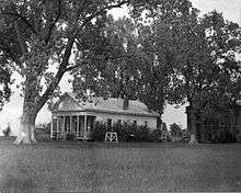 Historic photo of the Issaquena County Courthouse in Mayersville, Mississippi. | |
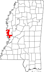 Location in the U.S. state of Mississippi | |
 Mississippi's location in the U.S. | |
| Founded | 1844 |
| Seat | Mayersville |
| Largest town | Mayersville |
| Area | |
| • Total | 441 sq mi (1,142 km2) |
| • Land | 413 sq mi (1,070 km2) |
| • Water | 28 sq mi (73 km2), 6.4% |
| Population (est.) | |
| • (2015) | 1,337 |
| • Density | 3.4/sq mi (1.3/km2) |
| Congressional district | 2nd |
| Time zone | Central: UTC−6/−5 |
Issaquena County is a county located in the U.S. state of Mississippi. As of the 2010 census, the population was 1,406,[1] making it the least populous county in the United States east of the Mississippi River. Its county seat is Mayersville.[2] With a per-capita income of $18,598, Issaquena County is the third poorest county in the United States.[3]
Issaquena County is located in the Mississippi Delta region. The Mississippi River flows along the entire western boundary of the county, and many of the earliest communities were river ports.
The county's economy is chiefly based on agriculture, though a number of hunting camps are also located here and contribute to the economy. Mississippi's two most recent records for the heaviest alligator taken by a hunter have both been in Issaquena County, the latest in 2012 when a 697.5 lb (316.4 kg) alligator was taken at a camp near Fitler.[4]
History
"Issaquena" is a Choctaw word meaning "Deer River".[5] The Choctaw people were the first inhabitants of the county, and were removed from their land in 1820.[6] Non-Native settlers began arriving in the early 1830s.
Issaquena county was established on January 23, 1844, from the southern portion of Washington County. The first county seat was located in Skipwith, and then moved to Duncansby (both communities are now ghost towns). In 1848, the county seat moved to Tallula, and in 1871, to Mayersville.[7]
The county lies entirely in the Mississippi Alluvial Plain, and hardwood forest known as "bottomland" grows thick in the nutrient-rich, high-clay "buckshot" soil. Early settlers cleared many forests, and by the early 1890s about 50,000 acres (20,000 ha) of the county was growing corn, cotton, and oats. About that same time, the Louisville, New Orleans and Texas Railway was completed along a north-south route through the center of the county.[8]
In 1876, Sharkey County was created from portions of Issaquena, Warren, and Washington counties.[9]
Slavery
Issaquena County is notable for its participation in slavery. In 1860, 92.5% of Issaquena County's total population were enslaved people, the highest concentration anywhere in the United States.[10] The U.S. Census for that year showed that 7,244 slaves were held in Issaquena County, and of 115 slave owners, 39 held 77 or more slaves.[11] Dr. Stephen Duncan of Issaquena County held 858 slaves, second only to Joshua John Ward of South Carolina.[12] This large "value of slave property" made Issaquena County the second richest in the nation, with "mean total wealth per freeman" at $26,800 in 1860.[13] By 1880—just 15 years after the abolition of slavery—the county had developed "a strong year-round market for wage labor", and Issaquena was the only county in Mississippi to report "no sharecropping or sharerenting whatsoever".[13]
Civil War
During the winter of 1862 and spring of 1863, Union Army General Ulysses S. Grant conducted a series of amphibious operations aimed at capturing the Confederate stronghold of Vicksburg, located south of Issaquena County.
The Steele's Bayou Expedition occurred on waterways within Issaquena County, including Steele Bayou, Little Sunflower River, Big Sunflower River, Deer Creek, Black Bayou, Little Black Bayou, and the Yazoo River.[14]
The shallow waterways proved difficult for the large Union boats, and Confederate defenses were robust. The Steele's Bayou Expedition was a defeat for Union forces in Issaquena County.[15]
Geography
According to the U.S. Census Bureau, the county has a total area of 441 square miles (1,140 km2), of which 413 square miles (1,070 km2) is land and 28 square miles (73 km2) (6.4%) is water.[16]
Major highways
Adjacent counties
- Washington County (north)
- Sharkey County (northeast)
- Yazoo County (east)
- Warren County (south)
- East Carroll Parish, Louisiana (west)
- Chicot County, Arkansas (northwest)
Demographics
| Historical population | |||
|---|---|---|---|
| Census | Pop. | %± | |
| 1850 | 4,478 | — | |
| 1860 | 7,831 | 74.9% | |
| 1870 | 6,887 | −12.1% | |
| 1880 | 10,004 | 45.3% | |
| 1890 | 12,318 | 23.1% | |
| 1900 | 10,400 | −15.6% | |
| 1910 | 10,560 | 1.5% | |
| 1920 | 7,618 | −27.9% | |
| 1930 | 5,734 | −24.7% | |
| 1940 | 6,433 | 12.2% | |
| 1950 | 4,966 | −22.8% | |
| 1960 | 3,576 | −28.0% | |
| 1970 | 2,737 | −23.5% | |
| 1980 | 2,513 | −8.2% | |
| 1990 | 1,909 | −24.0% | |
| 2000 | 2,274 | 19.1% | |
| 2010 | 1,406 | −38.2% | |
| Est. 2016 | 1,294 | [17] | −8.0% |
| U.S. Decennial Census[18] 1790-1960[19] 1900-1990[20] 1990-2000[21] 2010-2013[1] | |||
2010 United States Census
As of the 2010 United States Census, there were 1,406 people residing in the county. 64.4% were Black or African American, 34.6% White, 0.4% Asian, 0.2% Native American, 0.1% of some other race and 0.2% of two or more races. 0.6% were Hispanic or Latino (of any race).
2000 United States Census
As of the census[22] of 2000, there were 2,274 people, 726 households, and 509 families residing in the county. The population density was 5.15 people per square mile (2/km²). There were 877 housing units at an average density of 2 per square mile (1/km²). The racial makeup of the county was 36.32% White, 62.75% Black or African American, 0.09% Native American, 0.22% from other races, and 0.62% from two or more races. 0.44% of the population were Hispanic or Latino of any race.
There were 726 households out of which 34.20% had children under the age of 18 living with them, 45.60% were married couples living together, 16.00% had a female householder with no husband present, and 29.80% were non-families. 26.20% of all households were made up of individuals and 12.30% had someone living alone who was 65 years of age or older. The average household size was 2.77 and the average family size was 3.37.
In the county, the population was spread out with 27.70% under the age of 18, 10.90% from 18 to 24, 30.90% from 25 to 44, 19.90% from 45 to 64, and 10.70% who were 65 years of age or older. The median age was 33 years. For every 100 females there were 113.50 males. For every 100 females age 18 and over, there were 130.10 males.
The median income for a household in the county was $19,936, and the median income for a family was $23,913. Males had a median income of $23,167 versus $17,115 for females. The per capita income for the county was $10,581. About 25.90% of families and 33.20% of the population were below the poverty line, including 43.20% of those under age 18 and 41.00% of those age 65 or over.
Issaquena County has the second lowest per capita income in Mississippi and the 36th lowest in the United States.
Poverty and unemployment
Of 3,197 counties ranked by the U.S. Census Bureau in 2011 for "estimated percent of people of all ages in poverty", Issaquena was 14th; for those under age 18, the county was eighth. It was estimated that 40.1 percent of the county's residents lived in poverty.[23]
In 2014, Issaquena County had the highest percentage of unemployed people in Mississippi, and the fifth highest of any county in the United States, at 18.4 percent.[24]
Government and politics
The county is considered to be heavily Democratic, voting for Barack Obama in both 2008 and 2012.[25] However, the county voted for Republican senator Thad Cochran's reelection bid in 2014.[26]
| Year | Republican | Democratic | Third parties |
|---|---|---|---|
| 2016 | 42.6% 298 | 56.5% 395 | 0.9% 6 |
| 2012 | 38.4% 302 | 60.9% 479 | 0.8% 6 |
| 2008 | 38.3% 364 | 61.0% 579 | 0.7% 7 |
| 2004 | 45.3% 439 | 53.2% 516 | 1.6% 15 |
| 2000 | 38.9% 366 | 59.0% 555 | 2.1% 20 |
| 1996 | 30.8% 269 | 62.5% 546 | 6.6% 58 |
| 1992 | 30.1% 298 | 55.6% 550 | 14.3% 142 |
| 1988 | 43.6% 424 | 52.5% 511 | 3.9% 38 |
| 1984 | 49.5% 512 | 48.5% 501 | 2.0% 21 |
| 1980 | 36.1% 349 | 61.8% 598 | 2.2% 21 |
| 1976 | 34.1% 325 | 59.4% 567 | 6.5% 62 |
| 1972 | 60.8% 701 | 34.3% 395 | 4.9% 57 |
| 1968 | 4.0% 44 | 47.7% 527 | 48.3% 534 |
| 1964 | 93.1% 456 | 6.9% 34 | 0.0% 0 |
| 1960 | 15.1% 64 | 42.1% 178 | 42.8% 181 |
| 1956 | 14.5% 42 | 59.5% 172 | 26.0% 75 |
| 1952 | 42.8% 127 | 57.2% 170 | |
| 1948 | 2.2% 5 | 4.9% 11 | 92.9% 209 |
| 1944 | 2.3% 5 | 97.7% 215 | |
| 1940 | 4.0% 9 | 96.0% 218 | |
| 1936 | 100.0% 214 | ||
| 1932 | 0.6% 1 | 99.4% 159 | |
| 1928 | 4.3% 6 | 95.7% 134 | |
| 1924 | 11.9% 17 | 88.1% 126 | |
| 1920 | 13.5% 13 | 86.5% 83 | |
| 1916 | 7.6% 8 | 89.5% 94 | 2.9% 3 |
| 1912 | 2.7% 3 | 89.2% 99 | 8.1% 9 |
Education
There are no schools located in Issaquena County. Students attend campuses in neighboring Sharkey and Washington counties.
- Public School Districts[28]
- South Delta School District – Based in Rolling Fork; Serves most of Issaquena County including Mayersville. Operates South Delta High School.
- Western Line School District – Based in Avon; Serves northwestern portion of Issaquena County.
- Private Schools
- Sharkey-Issaquena Academy – Located in Rolling Fork; Enrollment open to Issaquena County residents.
In the segregation era (before around 1970) the county only had schools for black students.[29]
Communities
Town
Unincorporated communities
Ghost towns
Notable people
-cropped.jpg)
- Unita Blackwell, civil rights leader and mayor of Mayersville from 1976-2001; first female African-American mayor in Mississippi.
- Charles C. Diggs, Sr., first African-American Democrat elected to the Michigan Senate; born in Tallula.[30]
- William Stamps Farish II, president of Standard Oil; born in Mayersville.[31]
- Muddy Waters, blues musician (1913–1983); born in "Jug's Corner".[32]
- Eliza Winston, notable slave.
See also
- Blackwell v. Issaquena County Board of Education, an important 1965 civil rights legal case
- National Register of Historic Places listings in Issaquena County, Mississippi
- Stack Island (Mississippi River)
References
- 1 2 "State & County QuickFacts". United States Census Bureau. Archived from the original on July 12, 2011. Retrieved September 3, 2013.
- ↑ "Find a County". National Association of Counties. Archived from the original on 2011-05-31. Retrieved 2011-06-07.
- ↑ United States counties by per capita income
- ↑ "New Record Gator Bagged in MIssissippi". KNOE.COM. September 25, 2012. Archived from the original on February 1, 2014.
- ↑ Gannett, Henry (1905). The Origin of Certain Place Names in the United States. Govt. Print. Off. p. 167.
- ↑ Franks, Bob (2010). "Introduction". Issaquena Genealogy and History Project.
- ↑ Hellmann, Paul T. (2005). Historical Gazetteer of the United States. Routledge. ISBN 9780203997000.
- ↑ "Biographical and Historical Memoirs of Mississippi". General County History and Information. Issaquena Genealogy and History Project. Retrieved November 2013. Check date values in:
|accessdate=(help) - ↑ "About Sharkey County". Mississippi Genealogy & History Network. Retrieved November 2013. Check date values in:
|accessdate=(help) - ↑ Blake, Tom (2001). "Largest Slaveholders from 1860 Slave Census Schedules". Ancestry.com.
- ↑ Franks, Bob (2010). "Issaquena County Slave Research". Issaquena Genealogy and History Project.
- ↑ Blake, Tom (2004). "THE SIXTEEN LARGEST AMERICAN SLAVEHOLDERS FROM 1860 SLAVE CENSUS SCHEDULES". Ancestry.com.
- 1 2 Cobb, James C. (1992). The Most Southern Place on Earth: The Mississippi Delta and the Roots of Regional Identity. Oxford. ISBN 9780199762439.
- ↑ "Steele's Bayou Expedition". Rootsweb. Retrieved November 2013. Check date values in:
|accessdate=(help) - ↑ "Steele's Bayou Expedition". Mycivilwar.com. Retrieved November 2013. Check date values in:
|accessdate=(help) - ↑ "2010 Census Gazetteer Files". United States Census Bureau. August 22, 2012. Archived from the original on September 28, 2013. Retrieved November 4, 2014.
- ↑ "Population and Housing Unit Estimates". Retrieved June 9, 2017.
- ↑ "U.S. Decennial Census". United States Census Bureau. Archived from the original on May 12, 2015. Retrieved November 4, 2014.
- ↑ "Historical Census Browser". University of Virginia Library. Retrieved November 4, 2014.
- ↑ "Population of Counties by Decennial Census: 1900 to 1990". United States Census Bureau. Retrieved November 4, 2014.
- ↑ "Census 2000 PHC-T-4. Ranking Tables for Counties: 1990 and 2000" (PDF). United States Census Bureau. Retrieved November 4, 2014.
- ↑ "American FactFinder". United States Census Bureau. Retrieved 2008-01-31.
- ↑ "Table 1: 2011 Poverty and Median Income Estimates - Counties - Small Area Income and Poverty Estimates". U.S. Census Bureau. 2011. Archived from the original on 2013-10-10.
- ↑ "Labor Force Data by County, 2014 Annual Averages". U.S. Bureau of Labor Statistics. Retrieved July 2015. Check date values in:
|accessdate=(help) - ↑ "2012 Presidential General Election Results - Issaquena County, MS". Retrieved 2018-03-04.
- ↑ "2014 Senatorial General Election Results - Issaquena County, MS". Retrieved 2018-03-04.
- ↑ Leip, David. "Dave Leip's Atlas of U.S. Presidential Elections". uselectionatlas.org. Retrieved 2018-03-04.
- ↑ "SCHOOL DISTRICT REFERENCE MAP (2010 CENSUS): Issaquena County, MS." U.S. Census Bureau. Retrieved on July 4, 2017.
- ↑ Morris, Tiyi M. "Black Women Activists in Mississippi during the Civil Rights Era, 1954-1974." In: Glasrud, Bruce A. and Merline Pitre (editors). Southern Black Women in the Modern Civil Rights Movement. Start p. 137. CITED: p. 147.
- ↑ Dillard, Angela D. (2007). Faith in the City: Preaching Radical Social Change in Detroit. University of Michigan. ISBN 0472032070.
- ↑ Collins, Karen. "Farish, William Stamps". Handbook of Texas Online. Texas State Historical Association. Retrieved November 2013. Check date values in:
|accessdate=(help) - ↑ "Muddy Waters Birthplace". Mississippi Blues Commission. Retrieved October 2013. Check date values in:
|accessdate=(help)
Further reading
- Upholt, Boyce (2013-12-02). "The Hot Tamales of Issaquena County". Roads & Kingdoms. Retrieved 2014-07-01.
External links
- Sharkey-Issaquena County Library
- Sharkey-Issaquena County Health Department
- South Delta School District
- Western Line School District
- Delta National Forest
- Anderson-Tully State Wildlife Management Area
- Howard Miller Wildlife Management Area
- Shipland Wildlife Management Area
- Mahannah Wildlife Management Area
Coordinates: 32°44′N 90°59′W / 32.74°N 90.99°W
Places adjacent to Issaquena County, Mississippi | ||||||||||
|---|---|---|---|---|---|---|---|---|---|---|
| ||||||||||
Municipalities and communities of Issaquena County, Mississippi, United States | ||
|---|---|---|
| Town | | |
| Unincorporated communities | ||
| Ghost towns | ||
.svg.png)