Hinds County, Mississippi
| Hinds County, Mississippi | ||
|---|---|---|
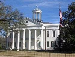 Hinds County courthouse in Raymond | ||
| ||
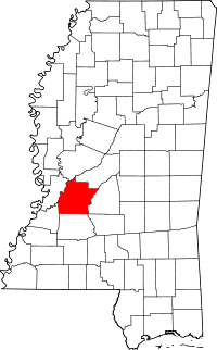 Location in the U.S. state of Mississippi | ||
 Mississippi's location in the U.S. | ||
| Founded | 1821 | |
| Named for | Thomas Hinds | |
| Seat | Jackson and Raymond | |
| Largest city | Jackson | |
| Area | ||
| • Total | 877 sq mi (2,271 km2) | |
| • Land | 870 sq mi (2,253 km2) | |
| • Water | 7.6 sq mi (20 km2), 0.9% | |
| Population (est.) | ||
| • (2015) | 242,891 | |
| • Density | 282/sq mi (109/km2) | |
| Congressional districts | 2nd, 3rd | |
| Time zone | Central: UTC−6/−5 | |
| Website |
www | |

Hinds County is a county located in the U.S. state of Mississippi. As of the 2010 census, the population was 245,285,[1] making it the most populous county in Mississippi. Its county seats are Raymond and Jackson, the state capital.[2] The county is named for General Thomas Hinds,[3] a hero of the Battle of New Orleans during the War of 1812.
Hinds County is part of the Jackson, MS Metropolitan Statistical Area. It is a center of professional, educational, business and industrial elites in the state. It is bordered on the northwest by the Big Black River and on the east by the Pearl River. It is one county width away from the Yazoo River and the southern border of the Mississippi Delta.
In the 19th century, the rural areas of the county were devoted to cotton plantations worked by enslaved African Americans and depended on agriculture well into the 20th century. From 1877 to 1950, this county had 22 lynchings, the highest number in the state. Mississippi has the highest total number of lynchings of any state.[4]
Geography
According to the U.S. Census Bureau, the county has a total area of 877 square miles (2,270 km2), of which 870 square miles (2,300 km2) is land and 7.6 square miles (20 km2) (0.9%) is water.[5] It is the third-largest county in Mississippi by land area and fifth-largest by total area.
Adjacent counties
- Madison County (northeast)
- Rankin County (east)
- Copiah County (south)
- Claiborne County (southwest)
- Warren County (west)
- Yazoo County (northwest)
National protected area
- Natchez Trace Parkway (part)
Transportation
Major highways
Airports
The following public-use airports are located in Hinds County:
- Hawkins Field (HKS) in Jackson
- John Bell Williams Airport (JVW) in Raymond
Demographics
| Historical population | |||
|---|---|---|---|
| Census | Pop. | %± | |
| 1830 | 8,645 | — | |
| 1840 | 19,098 | 120.9% | |
| 1850 | 25,340 | 32.7% | |
| 1860 | 31,339 | 23.7% | |
| 1870 | 30,488 | −2.7% | |
| 1880 | 43,958 | 44.2% | |
| 1890 | 39,279 | −10.6% | |
| 1900 | 52,577 | 33.9% | |
| 1910 | 63,726 | 21.2% | |
| 1920 | 57,110 | −10.4% | |
| 1930 | 85,118 | 49.0% | |
| 1940 | 107,273 | 26.0% | |
| 1950 | 142,164 | 32.5% | |
| 1960 | 187,045 | 31.6% | |
| 1970 | 214,973 | 14.9% | |
| 1980 | 250,998 | 16.8% | |
| 1990 | 254,441 | 1.4% | |
| 2000 | 250,800 | −1.4% | |
| 2010 | 245,285 | −2.2% | |
| Est. 2016 | 241,229 | [6] | −1.7% |
| U.S. Decennial Census[7] 1790-1960[8] 1900-1990[9] 1990-2000[10] 2010-2014[1] | |||
As of the 2010 United States Census, there were 245,285 people residing in the county. 69.1% were Black or African American, 28.4% White, 0.8% Asian, 0.2% Native American, 0.7% of some other race and 0.9% of two or more races. 1.5% were Hispanic or Latino (of any race).
As of the census[11] of 2000, there were 250,800 people, 91,030 households, and 62,355 families residing in the county. The population density was 288 people per square mile (111/km²). There were 100,287 housing units at an average density of 115 per square mile (45/km²). The racial makeup of the county was 61.12% Black or African American, 37.31% White, 0.12% Native American, 0.60% Asian, 0.01% Pacific Islander, 0.20% from other races, and 0.63% from two or more races. 0.79% of the population were Hispanic or Latino of any race.
There were 91,030 households out of which 34.40% had children under the age of 18 living with them, 41.10% were married couples living together, 22.70% had a female householder with no husband present, and 31.50% were non-families. 26.70% of all households were made up of individuals and 8.70% had someone living alone who was 65 years of age or older. The average household size was 2.64 and the average family size was 3.22.
In the county, the population was spread out with 27.90% under the age of 18, 12.10% from 18 to 24, 28.90% from 25 to 44, 20.10% from 45 to 64, and 11.00% who were 65 years of age or older. The median age was 32 years. For every 100 females, there were 88.80 males. For every 100 females age 18 and over, there were 83.50 males.
The median income for a household in the county was $33,991, and the median income for a family was $40,525. Males had a median income of $30,930 versus $24,593 for females. The per capita income for the county was $17,785. About 16.10% of families and 19.90% of the population were below the poverty line, including 28.60% of those under age 18 and 15.10% of those age 65 or over.
Hinds County has the seventh highest per capita income in the State of Mississippi.
Government
Hinds County is governed via a five-member board of supervisors, each elected from single-member districts. The county is led by a county administrator, who is appointed.
The Mississippi Department of Human Services (MDHS) has its headquarters in Jackson and in Hinds County. The Division of Youth Services operates the Oakley Training School (OTS) in an unincorporated area of Hinds County.[12]
The Mississippi Department of Corrections has its headquarters in Jackson and in Hinds County.[13] It operates the Jackson Probation & Parole Office in the city.
| Year | Republican | Democratic | Third parties |
|---|---|---|---|
| 2016 | 26.6% 25,275 | 71.1% 67,594 | 2.3% 2,208 |
| 2012 | 27.9% 29,664 | 71.5% 76,112 | 0.7% 715 |
| 2008 | 30.3% 32,949 | 69.2% 75,401 | 0.5% 552 |
| 2004 | 40.0% 36,975 | 59.3% 54,845 | 0.7% 680 |
| 2000 | 43.0% 37,753 | 53.3% 46,789 | 3.7% 3,228 |
| 1996 | 42.2% 35,653 | 53.7% 45,410 | 4.1% 3,446 |
| 1992 | 46.9% 45,031 | 45.2% 43,434 | 7.9% 7,559 |
| 1988 | 55.5% 52,749 | 43.2% 41,058 | 1.3% 1,199 |
| 1984 | 56.7% 56,953 | 42.2% 42,373 | 1.1% 1,142 |
| 1980 | 53.4% 48,135 | 43.7% 39,369 | 2.9% 2,570 |
| 1976 | 60.5% 45,803 | 38.0% 28,748 | 1.6% 1,205 |
| 1972 | 77.8% 49,877 | 19.8% 12,679 | 2.4% 1,540 |
| 1968 | 22.2% 13,488 | 24.5% 14,880 | 53.3% 32,366 |
| 1964 | 87.9% 36,831 | 12.1% 5,058 | |
| 1960 | 38.2% 11,083 | 20.1% 5,811 | 41.7% 12,094 |
| 1956 | 34.6% 7,015 | 35.0% 7,104 | 30.4% 6,159 |
| 1952 | 53.4% 12,520 | 46.6% 10,933 | |
| 1948 | 3.2% 492 | 6.8% 1,041 | 90.0% 13,722 |
| 1944 | 8.4% 962 | 91.6% 10,466 | |
| 1940 | 5.1% 538 | 94.8% 9,917 | 0.0% 4 |
| 1936 | 3.5% 313 | 96.3% 8,647 | 0.2% 16 |
| 1932 | 5.8% 403 | 93.7% 6,541 | 0.6% 39 |
| 1928 | 14.6% 976 | 85.4% 5,707 | |
| 1924 | 5.5% 245 | 90.8% 4,083 | 3.8% 170 |
| 1920 | 5.5% 151 | 92.0% 2,510 | 2.5% 67 |
| 1916 | 4.2% 97 | 95.0% 2,220 | 0.9% 20 |
| 1912 | 1.8% 40 | 92.9% 2,065 | 5.3% 118 |
Education
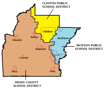
Public school districts
Private schools
- Clinton Christian Academy (Clinton)
- Hillcrest Christian School (Jackson)
- Jackson Academy (Jackson)
- Mt. Salus Christian School (Clinton)
- Rebul Academy (Learned)
- Central Hinds Academy(Raymond)
Colleges and universities
- Belhaven University (Jackson)
- Hinds Community College (Raymond)
- Jackson State University (Jackson)
- Millsaps College (Jackson)
- Mississippi College (Clinton)
- Mississippi College School of Law (Jackson)
- Reformed Theological Seminary (Jackson)
- Tougaloo College (Tougaloo)
- University of Mississippi Medical Center (Jackson)
- Wesley Biblical Seminary (Jackson)
Communities
Cities
Towns
Unincorporated communities
- Brownsville
- Dabney Crossroads
- Midway
- Oakley
- Pocahontas
- Turkey Creek
Notable people
- Kate Stone (1841–1907), diarist
See also
References
- 1 2 "State & County QuickFacts". United States Census Bureau. Archived from the original on July 11, 2011. Retrieved September 3, 2013.
- ↑ "Find a County". National Association of Counties. Archived from the original on May 31, 2011. Retrieved 2011-06-07.
- ↑ Gannett, Henry (1905). The Origin of Certain Place Names in the United States. Govt. Print. Off. p. 157.
- ↑ Lynching in America, 2nd edition, Supplement by County, p. 5
- ↑ "2010 Census Gazetteer Files". United States Census Bureau. August 22, 2012. Archived from the original on September 28, 2013. Retrieved November 4, 2014.
- ↑ "Population and Housing Unit Estimates". Retrieved June 9, 2017.
- ↑ "U.S. Decennial Census". United States Census Bureau. Archived from the original on May 12, 2015. Retrieved October 21, 2014.
- ↑ "Historical Census Browser". University of Virginia Library. Retrieved October 21, 2014.
- ↑ "Population of Counties by Decennial Census: 1900 to 1990". United States Census Bureau. Retrieved October 21, 2014.
- ↑ "Census 2000 PHC-T-4. Ranking Tables for Counties: 1990 and 2000" (PDF). United States Census Bureau. Retrieved October 21, 2014.
- ↑ "American FactFinder". United States Census Bureau. Retrieved 2008-01-31.
- ↑ Mississippi Department of Human Services website Archived 2010-01-13 at the Wayback Machine.
- ↑ Mississippi Department of Corrections homepage. Retrieved on December 8, 2009
- ↑ Leip, David. "Dave Leip's Atlas of U.S. Presidential Elections". uselectionatlas.org. Retrieved 2018-03-04.
External links
- Hinds County - Official site.
- Hinds County Courthouse Pictures
Places adjacent to Hinds County, Mississippi | ||||||||||
|---|---|---|---|---|---|---|---|---|---|---|
| ||||||||||
Municipalities and communities of Hinds County, Mississippi, United States | ||
|---|---|---|
| Cities | | |
| Towns | ||
| Unincorporated communities | ||
| Footnotes | ‡ This populated place also has portions in an adjacent county or counties | |
.svg.png)