Jefferson Davis County, Mississippi
| Jefferson Davis County, Mississippi | |
|---|---|
| County | |
| County of Jefferson Davis | |
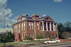 Jefferson Davis County courthouse in Prentiss | |
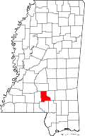 Location in the U.S. state of Mississippi | |
 Mississippi's location in the U.S. | |
| Founded | 1906 |
| Named for | Jefferson Davis |
| Seat | Prentiss |
| Largest town | Prentiss |
| Area | |
| • Total | 409 sq mi (1,059 km2) |
| • Land | 408 sq mi (1,057 km2) |
| • Water | 0.7 sq mi (2 km2), 0.2% |
| Population | |
| • (2010) | 12,487 |
| • Density | 31/sq mi (12/km2) |
| Congressional district | 3rd |
| Time zone | Central: UTC−6/−5 |
| Website | www.jeffersondaviscountyms.com |
Jefferson Davis County is a county located in the U.S. state of Mississippi. As of the 2010 census, the population was 12,487.[1] Its county seat is Prentiss.[2] The county is named in honor of Mississippi Senator and Confederate President Jefferson Davis. The county was carved out of Covington and Lawrence counties in March 1906. Governor James K. Vardaman signed the bill creating the county on May 9, 1906.
History
The genesis of the county occurred on March 31, 1906, when a Mississippi state legislative act authorized the new country's boundaries. The residents of western Covington County and eastern Lawrence County had frequently complained of the rivers and streams impeding the route to their respective county seats. Jefferson Davis County was the state's 77th county.
A 1906 special referendum determined that the county seat would be Prentiss, named for either famed Mississippi lawmaker and orator Seargent Smith Prentiss, or wealthy landowner Prentiss Webb Berry. The settlement was originally named Blountville after early settler William Blount.
In 1933, the county was the first in Mississippi to issue a prohibition on alcohol after the repeal of the Eighteenth Amendment to the United States Constitution. Round dancing in the community hall was banned in 1938.
In 1935, notorious bank robber Raymond Hamilton, known to hide out in the county's wilderness, was involved in a hostage situation after robbing Prentiss' Bank of Blountville, but escaped in Memphis.[3]
Geography
According to the U.S. Census Bureau, the county has a total area of 409 square miles (1,060 km2), of which 408 square miles (1,060 km2) is land and 0.7 square miles (1.8 km2) (0.2%) is water.[4]
Major highways
Adjacent counties
- Simpson County (north)
- Covington County (east)
- Lamar County (southeast)
- Marion County (south)
- Lawrence County (west)
Demographics
| Historical population | |||
|---|---|---|---|
| Census | Pop. | %± | |
| 1910 | 12,860 | — | |
| 1920 | 12,755 | −0.8% | |
| 1930 | 14,281 | 12.0% | |
| 1940 | 15,869 | 11.1% | |
| 1950 | 15,500 | −2.3% | |
| 1960 | 13,540 | −12.6% | |
| 1970 | 12,936 | −4.5% | |
| 1980 | 13,846 | 7.0% | |
| 1990 | 14,051 | 1.5% | |
| 2000 | 13,962 | −0.6% | |
| 2010 | 12,487 | −10.6% | |
| Est. 2016 | 11,385 | [5] | −8.8% |
| U.S. Decennial Census[6] 1790-1960[7] 1900-1990[8] 1990-2000[9] 2010-2013[1] | |||
As of the 2010 United States Census, there were 12,487 people residing in the county. 59.9% were Black or African American, 38.7% White, 0.3% Native American, 0.1% Asian, 0.3% of some other race and 0.7% of two or more races. 0.8% were Hispanic or Latino (of any race).
As of the census[10] of 2000, there were 13,962 people, 5,177 households, and 3,768 families residing in the county. The population density was 34 people per square mile (13/km²). There were 5,891 housing units at an average density of 14 per square mile (6/km²). The racial makeup of the county was 57.38% Black or African American, 41.66% White, 0.14% Native American, 0.18% Asian, 0.01% Pacific Islander, 0.08% from other races, and 0.57% from two or more races. 0.77% of the population were Hispanic or Latino of any race.
There were 5,177 households out of which 32.9% had children under the age of 18 living with them, 45.7% were married couples living together, 21.6% had a female householder with no husband present, and 27.2% were non-families. 25.0% of all households were made up of individuals and 11.9% had someone living alone who was 65 years of age or older. The average household size was 2.68 and the average family size was 3.20.
In the county, the population was spread out with 28.4% under the age of 18, 9.9% from 18 to 24, 25.4% from 25 to 44, 22.5% from 45 to 64, and 13.8% who were 65 years of age or older. The median age was 35 years. For every 100 females there were 89.9 males. For every 100 females age 18 and over, there were 84.7 males.
The median income for a household in the county was $21,834, and the median income for a family was $27,594. Males had a median income of $23,942 versus $16,510 for females. The per capita income for the county was $11,974. About 23.2% of families and 28.2% of the population were below the poverty line, including 38.7% of those under age 18 and 24.5% of those age 65 or over.
Communities
Towns
Unincorporated communities
- Carson
- Oak Vale (partly in Lawrence County)
- Society Hill
Ghost town
Politics
| Year | Republican | Democratic | Third parties |
|---|---|---|---|
| 2016 | 39.5% 2,466 | 59.6% 3,720 | 0.8% 51 |
| 2012 | 36.5% 2,507 | 62.2% 4,267 | 1.3% 90 |
| 2008 | 39.0% 2,871 | 60.4% 4,454 | 0.6% 45 |
| 2004 | 46.3% 2,668 | 51.3% 2,959 | 2.4% 138 |
| 2000 | 45.8% 2,437 | 53.3% 2,835 | 0.9% 45 |
| 1996 | 38.8% 1,890 | 54.7% 2,663 | 6.4% 313 |
| 1992 | 39.6% 2,228 | 53.1% 2,991 | 7.4% 414 |
| 1988 | 47.9% 2,745 | 51.5% 2,948 | 0.6% 35 |
| 1984 | 51.8% 2,884 | 47.5% 2,644 | 0.7% 38 |
| 1980 | 36.9% 2,280 | 61.9% 3,831 | 1.2% 76 |
| 1976 | 39.8% 1,868 | 58.5% 2,747 | 1.8% 83 |
| 1972 | 72.8% 2,830 | 25.9% 1,005 | 1.3% 51 |
| 1968 | 6.8% 297 | 33.5% 1,465 | 59.7% 2,614 |
| 1964 | 90.9% 2,351 | 9.1% 235 | |
| 1960 | 13.1% 225 | 29.6% 510 | 57.3% 988 |
| 1956 | 10.9% 156 | 73.4% 1,049 | 15.7% 224 |
| 1952 | 22.5% 473 | 77.5% 1,626 | |
| 1948 | 3.3% 51 | 2.7% 41 | 94.0% 1,452 |
| 1944 | 6.0% 88 | 94.0% 1,372 | |
| 1940 | 2.9% 38 | 96.9% 1,289 | 0.2% 3 |
| 1936 | 4.8% 67 | 95.1% 1,325 | 0.1% 2 |
| 1932 | 3.1% 30 | 96.7% 940 | 0.2% 2 |
| 1928 | 16.0% 163 | 84.0% 856 | |
| 1924 | 10.7% 88 | 89.3% 732 | |
| 1920 | 26.8% 179 | 72.5% 485 | 0.8% 5 |
| 1916 | 6.6% 45 | 92.8% 634 | 0.6% 4 |
| 1912 | 6.6% 43 | 83.5% 542 | 9.9% 64 |
See also
References
- 1 2 "State & County QuickFacts". United States Census Bureau. Archived from the original on July 12, 2011. Retrieved September 3, 2013.
- ↑ "Find a County". National Association of Counties. Archived from the original on 2011-05-31. Retrieved 2011-06-07.
- ↑ "Jefferson Davis County Mississippi Genealogy & History Network". jeffdavis.msghn.org. Retrieved 2018-03-03.
- ↑ "2010 Census Gazetteer Files". United States Census Bureau. August 22, 2012. Archived from the original on September 28, 2013. Retrieved November 4, 2014.
- ↑ "Population and Housing Unit Estimates". Retrieved June 9, 2017.
- ↑ "U.S. Decennial Census". United States Census Bureau. Archived from the original on May 12, 2015. Retrieved November 4, 2014.
- ↑ "Historical Census Browser". University of Virginia Library. Retrieved November 4, 2014.
- ↑ "Population of Counties by Decennial Census: 1900 to 1990". United States Census Bureau. Retrieved November 4, 2014.
- ↑ "Census 2000 PHC-T-4. Ranking Tables for Counties: 1990 and 2000" (PDF). United States Census Bureau. Retrieved November 4, 2014.
- ↑ "American FactFinder". United States Census Bureau. Retrieved 2008-01-31.
- ↑ Leip, David. "Dave Leip's Atlas of U.S. Presidential Elections". uselectionatlas.org. Retrieved 2018-03-03.
External links
- Jefferson Davis County Website
- Jefferson Davis County Courthouse Pictures
- Jefferson Davis County Economic Development District Website
Places adjacent to Jefferson Davis County, Mississippi | ||||||||||
|---|---|---|---|---|---|---|---|---|---|---|
| ||||||||||
Municipalities and communities of Jefferson Davis County, Mississippi, United States | ||
|---|---|---|
| Towns | | |
| Unincorporated communities | ||
| ghost town | ||
| Footnotes | ‡This community also has portions in adjacent county or counties | |
.svg.png)