Tishomingo County, Mississippi
| Tishomingo County, Mississippi | |
|---|---|
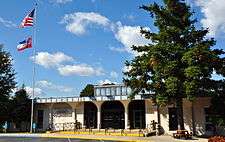 Tishomingo County Courthouse | |
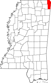 Location in the U.S. state of Mississippi | |
 Mississippi's location in the U.S. | |
| Founded | February 9, 1836 |
| Named for | Chief Tishomingo |
| Seat | Iuka |
| Largest city | Iuka |
| Area | |
| • Total | 445 sq mi (1,153 km2) |
| • Land | 424 sq mi (1,098 km2) |
| • Water | 20 sq mi (52 km2), 4.6% |
| Population | |
| • (2010) | 19,593 |
| • Density | 46/sq mi (18/km2) |
| Congressional district | 1st |
| Time zone | Central: UTC−6/−5 |
Tishomingo County is a county located in the northeast corner of the U.S. state of Mississippi. As of the 2010 census, the population was 19,593.[1] Its county seat is Iuka.[2]
History
Tishomingo County was organized February 9, 1836, from Chickasaw lands that were ceded to the United States. The Chickasaw were forced by Indian Removal to relocate to lands in the Indian Territory (now Oklahoma). In 1870 this land was divided into Alcorn, Prentiss and Tishomingo counties.

Tishomingo was referred to in the Coen brothers' film, O Brother, Where Art Thou?.
Government
Board of supervisors
- Brandon Grissom, District 1
- Nicky McRae, District 2
- Danny Ryan, District 3
- Jeff Holt, District 4
- Greg Collier, District 5
Chancery clerk
- Peyton Cummings
State representatives
- Representative Lester Carpenter, Mississippi House of Representatives - District 1
- Representative Mark DuVall, Mississippi House of Representatives - District 19
- Senator Eric Powell, Mississippi State Senate - District 4
- Senator J. P. Wilemon, Mississippi State Senate - District 5
| Year | Republican | Democratic | Third parties |
|---|---|---|---|
| 2016 | 85.6% 7,166 | 11.9% 999 | 2.5% 206 |
| 2012 | 77.3% 6,133 | 20.7% 1,643 | 2.0% 160 |
| 2008 | 74.2% 6,249 | 23.3% 1,962 | 2.5% 208 |
| 2004 | 64.5% 5,379 | 34.1% 2,846 | 1.4% 113 |
| 2000 | 59.0% 4,122 | 39.3% 2,747 | 1.8% 123 |
| 1996 | 45.3% 2,766 | 44.3% 2,709 | 10.4% 634 |
| 1992 | 42.0% 3,393 | 48.4% 3,910 | 9.5% 769 |
| 1988 | 51.7% 3,646 | 47.9% 3,378 | 0.4% 28 |
| 1984 | 54.9% 3,527 | 44.8% 2,879 | 0.3% 22 |
| 1980 | 34.5% 2,489 | 63.6% 4,595 | 1.9% 137 |
| 1976 | 33.7% 1,969 | 64.0% 3,734 | 2.3% 136 |
| 1972 | 89.2% 4,177 | 9.5% 443 | 1.3% 61 |
| 1968 | 11.1% 617 | 6.5% 358 | 82.4% 4,569 |
| 1964 | 66.4% 1,934 | 33.6% 977 | |
| 1960 | 22.1% 536 | 50.4% 1,222 | 27.6% 669 |
| 1956 | 23.8% 516 | 72.7% 1,577 | 3.6% 77 |
| 1952 | 29.9% 679 | 70.1% 1,595 | |
| 1948 | 5.2% 98 | 37.7% 711 | 57.1% 1,075 |
| 1944 | 17.3% 296 | 82.7% 1,412 | |
| 1940 | 9.8% 159 | 89.8% 1,463 | 0.5% 8 |
| 1936 | 6.6% 115 | 92.8% 1,619 | 0.6% 10 |
| 1932 | 6.4% 112 | 93.3% 1,636 | 0.3% 6 |
| 1928 | 37.7% 585 | 62.3% 965 | |
| 1924 | 19.1% 279 | 80.9% 1,181 | |
| 1920 | 31.0% 387 | 67.3% 841 | 1.7% 21 |
| 1916 | 14.3% 175 | 84.2% 1,031 | 1.6% 19 |
| 1912 | 7.2% 65 | 77.5% 701 | 15.3% 138 |
Geography
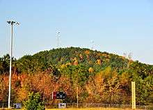
According to the U.S. Census Bureau, the county has a total area of 445 square miles (1,150 km2), of which 424 square miles (1,100 km2) is land and 20 square miles (52 km2) (4.6%) is water.[4] The highest natural point in Mississippi, the 806 feet (246 meter) Woodall Mountain, is located in the county. Tishomingo County is the only county in Mississippi with outcroppings of natural limestone formations.[5]
Adjacent counties
- Hardin County, Tennessee (north)
- Lauderdale County, Alabama (northeast)
- Colbert County, Alabama (east)
- Franklin County, Alabama (southeast)
- Itawamba County (south)
- Prentiss County (southwest)
- Alcorn County (northwest)
Major highways
National protected area
Demographics
| Historical population | |||
|---|---|---|---|
| Census | Pop. | %± | |
| 1840 | 6,681 | — | |
| 1850 | 15,490 | 131.9% | |
| 1860 | 24,149 | 55.9% | |
| 1870 | 7,350 | −69.6% | |
| 1880 | 8,774 | 19.4% | |
| 1890 | 9,302 | 6.0% | |
| 1900 | 10,124 | 8.8% | |
| 1910 | 13,067 | 29.1% | |
| 1920 | 15,091 | 15.5% | |
| 1930 | 16,411 | 8.7% | |
| 1940 | 16,974 | 3.4% | |
| 1950 | 15,544 | −8.4% | |
| 1960 | 13,889 | −10.6% | |
| 1970 | 14,940 | 7.6% | |
| 1980 | 18,434 | 23.4% | |
| 1990 | 17,683 | −4.1% | |
| 2000 | 19,163 | 8.4% | |
| 2010 | 19,593 | 2.2% | |
| Est. 2016 | 19,491 | [6] | −0.5% |
| U.S. Decennial Census[7] 1790-1960[8] 1900-1990[9] 1990-2000[10] 2010-2013[1] | |||
As of the 2010 United States Census, there were 19,593 people residing in the county. 94.5% were White, 2.6% Black or African American, 0.2% Native American, 0.1% Asian, 1.7% of some other race and 0.8% of two or more races. 2.8% were Hispanic or Latino (of any race).
As of the census[11] of 2000 there were 19,163 people, 7,917 households, and 5,573 families residing in the county. The population density was 45 people per square mile (17/km²). There were 9,553 housing units at an average density of 22 per square mile (9/km²). The racial makeup of the county was 94.93% White, 3.11% Black or African American, 0.21% Native American, 0.08% Asian, 0.01% Pacific Islander, 1.06% from other races, and 0.59% from two or more races. 1.79% of the population were Hispanic or Latino of any race.
By 2005 the population was 93.4% non-Hispanic white. 3.6% of the population was African-American. 2.6% of the population was Latino.
In 2000 there were 7,917 households out of which 30.2% had children under the age of 18 living with them, 57.1% were married couples living together, 10.1% had a female householder with no husband present, and 29.6% were non-families. 27.5% of all households were made up of individuals and 12.8% had someone living alone who was 65 years of age or older. The average household size was 2.39 and the average family size was 2.89.
In the county, the population was spread out with 23.2% under the age of 18, 7.8% from 18 to 24, 27.5% from 25 to 44, 24.7% from 45 to 64, and 16.8% who were 65 years of age or older. The median age was 39 years. For every 100 females there were 92.7 males. For every 100 females age 18 and over, there were 89.8 males.
The median income for a household in the county was $28,315, and the median income for a family was $34,378. Males had a median income of $28,109 versus $19,943 for females. The per capita income for the county was $15,395. About 11% of families and 14.1% of the population were below the poverty line, including 15.6% of those under age 18 and 15.6% of those age 65 or over.
Recreation
- Tishomingo State Park is located in the foothills of the Appalachian Mountains in Tishomingo County, Mississippi, north of Tupelo, Mississippi. Activities in the park including canoeing, rock climbing, fishing and hiking. The park was constructed by the Civilian Conservation Corps during the 1930s. Many of the original buildings are still standing. The park is named for an early leader of the Chickasaw nation, Chief Tishomingo (1734-1838).
- J.P. Coleman State Park is a state park in the U.S. state of Mississippi. It is located north of Iuka off Mississippi Highway 25. It sits along the banks of the Tennessee River and Pickwick Lake. The park is named for James P. Coleman, a former governor of Mississippi. Activities include sailing, swimming, camping, hiking, skiing, and fishing for smallmouth bass.
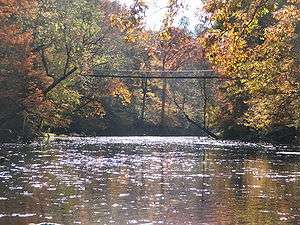
- Bay Springs Lake is a reservoir on the Tennessee-Tombigbee Waterway in the U.S. state of Mississippi. It is impounded by the Jamie Whitten Lock and Dam. The lake is approximately nine miles long, between waterway mile markers 412 at the dam, and 421 near the entrance to the divide cut.
- The Tennessee–Tombigbee Waterway (popularly known as the Tenn-Tom) is a 234-mile (377 km) artificial waterway that provides a connecting link between the Tennessee and Tombigbee rivers. The waterway begins at Pickwick Lake on the Tennessee River, then flows southward through northeast Mississippi and west Alabama, finally connecting with the established Warrior-Tombigbee navigation system at Demopolis, Alabama.
Communities
City
- Iuka (county seat)
Towns
Villages
Unincorporated communities
Gallery
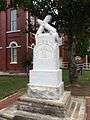 Monument to Confederate soldiers who served in the American Civil War
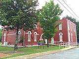
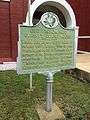 State historical marker for Old Tishomingo County Courthouse
See also
- Battle of Iuka
- Jacinto, historic county seat of the original Tishomingo County
- Natchez Trace Parkway
- National Register of Historic Places listings in Tishomingo County, Mississippi
- Woodall Mountain
References
- 1 2 "State & County QuickFacts". United States Census Bureau. Retrieved September 7, 2013.
- ↑ "Find a County". National Association of Counties. Retrieved 2011-06-07.
- ↑ Leip, David. "Dave Leip's Atlas of U.S. Presidential Elections". uselectionatlas.org. Retrieved 2018-03-05.
- ↑ "2010 Census Gazetteer Files". United States Census Bureau. August 22, 2012. Archived from the original on September 28, 2013. Retrieved November 8, 2014.
- ↑ Lowe, Ephraim Noble; Survey, Mississippi Geological, Economic, and Topographical (1915). Bulletin - Mississippi State Geological Survey. Mississippi Geological, Economic and Topographical Survey.
- ↑ "Population and Housing Unit Estimates". Retrieved June 9, 2017.
- ↑ "U.S. Decennial Census". United States Census Bureau. Retrieved November 8, 2014.
- ↑ "Historical Census Browser". University of Virginia Library. Retrieved November 8, 2014.
- ↑ "Population of Counties by Decennial Census: 1900 to 1990". United States Census Bureau. Retrieved November 8, 2014.
- ↑ "Census 2000 PHC-T-4. Ranking Tables for Counties: 1990 and 2000" (PDF). United States Census Bureau. Retrieved November 8, 2014.
- ↑ "American FactFinder". United States Census Bureau. Retrieved 2008-01-31.
External links
Municipalities and communities of Tishomingo County, Mississippi, United States | ||
|---|---|---|
| City | | |
| Towns | ||
| Village | ||
| Unincorporated communities | ||
| Ghost town | ||
.svg.png)