Hattiesburg metropolitan area
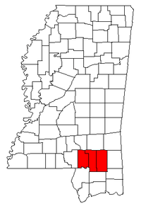
The Hattiesburg Metropolitan Statistical Area is a metropolitan area in southeastern Mississippi that covers three counties - Forrest, Lamar, and Perry. As of the 2000 census, the MSA had a population of 123,812 (though a July 1, 2009 estimate placed the population at 143,093).[1]
Counties
Communities
Cities and towns
- Beaumont
- Hattiesburg (Principal city)
- Lumberton
- New Augusta
- Petal
- Purvis
- Richton
- Sumrall
Census-designated places
Unincorporated places
Demographics
As of the census[2] of 2000, there were 123,812 people, 45,999 households, and 31,372 families residing within the MSA. The racial makeup of the MSA was 72.13% White, 25.96% African American, 0.20% Native American, 0.65% Asian, 0.02% Pacific Islander, 0.36% from other races, and 0.69% from two or more races. Hispanic or Latino of any race were 1.18% of the population.
The median income for a household in the MSA was $30,746, and the median income for a family was $37,731. Males had a median income of $30,221 versus $20,464 for females. The per capita income for the MSA was $15,615.
See also
References
- ↑ "Table 1. Annual Estimates of the Population of Metropolitan and Micropolitan Statistical Areas: April 1, 2000 to July 1, 2009 (CBSA-EST2009-01)" (CSV). 2009 Population Estimates. United States Census Bureau, Population Division. 2010-03-23. Retrieved 2010-03-25.
- ↑ "American FactFinder". United States Census Bureau. Retrieved 2008-01-31.
.svg.png)