Gautier, Mississippi
| Gautier, Mississippi | |
|---|---|
| City | |
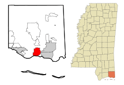 Location of Gautier, Mississippi | |
 Gautier, Mississippi Location in the United States | |
| Coordinates: 30°22′54″N 88°38′39″W / 30.38167°N 88.64417°WCoordinates: 30°22′54″N 88°38′39″W / 30.38167°N 88.64417°W | |
| Country | United States |
| State | Mississippi |
| County | Jackson |
| Area | |
| • Total | 32.1 sq mi (83.2 km2) |
| • Land | 30.2 sq mi (78.3 km2) |
| • Water | 1.9 sq mi (4.9 km2) |
| Elevation | 7 ft (2 m) |
| Population (2010)[1] | |
| • Total | 18,572 |
| • Estimate (2016)[2] | 18,471 |
| • Density | 614/sq mi (237.2/km2) |
| Time zone | UTC−6 (Central (CST)) |
| • Summer (DST) | UTC−5 (CDT) |
| ZIP code | 39553 |
| Area code(s) | 228 |
| FIPS code | 28-26860 |
| GNIS feature ID | 0670341 |
| Website |
www |
Gautier (/ˈɡoʊtʃeɪ/ GOH-chay; French: [ɡotje]) is a city in Jackson County, Mississippi, United States, along the Gulf of Mexico west of Pascagoula. It is part of the Pascagoula Metropolitan Statistical Area. The population was 18,572 at the 2010 census,[1] up from 11,681 at the 2000 census. In 2002, Gautier had annexed land more than doubling its area.[3]
Gautier is a bedroom resort community surrounded by bayous and wetlands on three sides. The natural environment of Gautier offers many opportunities for recreation and eco-tourism. The Gulf Coast region, of which Gautier is a part, has been considered a relatively high growth area of the state; however, the loss of houses and jobs after Hurricane Katrina led to outmigration in 2006.
History
The town takes its name from the Gautier family that originated in Lyon, France. Fernando Upton Gautier (1822–1891) was born on a cargo ship as his parents were emigrating to New Orleans. In 1867, Gautier established a spacious homestead[4] at the mouth of the Pascagoula River, which still stands. He established a lucrative sawmill business in the area, and the town grew up from it. The home, known by locals as "The Old Place", is owned by the descendants of Fernando Upton Gautier and his wife, Theresa Fayard Gautier (1828–1911),[4] and is used for private and public events.
Government
The city of Gautier has had a City Manager-Council organizational structure since 1987. Although Hurricane Katrina in 2005 slowed growth, the population of Gautier is expected to grow at a steady rate during the coming decades. The socio-economic demographics of the city is similar to that of Jackson County in terms of income, age, gender and education, although Gautier has a higher rate of college-educated persons. The income and employment of residents benefits greatly from the proximity of strong employment centers in Jackson County.
Geography
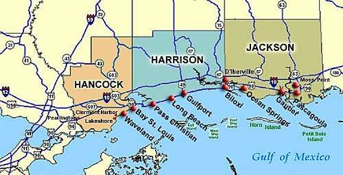
Gautier is located in southern Jackson County at 30°22′54″N 88°38′39″W / 30.38167°N 88.64417°W (30.381536, -88.644169),[5] along Mississippi Sound of the Gulf of Mexico, at the mouth of the West Pascagoula River, locally known as the "Singing River".[6] The city is bordered to the east by the city of Pascagoula (the Jackson county seat) and to the west by Ocean Springs, and to the north by unincorporated Vancleave.
U.S. Route 90 passes through the center of Gautier, leading east 4 miles (6 km) into Pascagoula and 13 miles (21 km) to Ocean Springs. Interstate 10 passes through the northern part of the city limits, with access from Exit 57 (Mississippi Highway 57) and Exit 61 (Gautier Vancleave Road). I-10 leads west 30 miles (48 km) to the Gulfport area and east 42 miles (68 km) to Mobile, Alabama.
According to the United States Census Bureau, the city of Gautier has a total area of 32.1 square miles (83.2 km2), of which 30.2 square miles (78.3 km2) are land and 1.9 square miles (4.9 km2), or 5.90%, are water.[1]
Demographics
| Historical population | |||
|---|---|---|---|
| Census | Pop. | %± | |
| 1970 | 2,087 | — | |
| 1980 | 8,917 | 327.3% | |
| 1990 | 10,088 | 13.1% | |
| 2000 | 11,681 | 15.8% | |
| 2010 | 18,572 | 59.0% | |
| Est. 2016 | 18,471 | [2] | −0.5% |
| U.S. Decennial Census[7] 2012 Estimate[8] | |||
As of the census of 2000, there were 11,681 people, 4,260 households, and 3,233 families residing in the city. The population density was 954.2 people per square mile (368.5/km²). There were 4,597 housing units at an average density of 375.5 per square mile (145.0/km²). The racial makeup of the city was 68.19% White, 27.65% African American, 0.51% Native American, 1.28% Asian, 0.04% Pacific Islander, 0.90% from other races, and 1.42% from two or more races. Hispanic or Latino of any race were 3.19% of the population.
There were 4,260 households out of which 38.1% had children under the age of 18 living with them, 54.9% were married couples living together, 17.1% had a female householder with no husband present, and 24.1% were non-families. 19.3% of all households were made up of individuals and 4.5% had someone living alone who was 65 years of age or older. The average household size was 2.73 and the average family size was 3.11.
In the city, the population was spread out with 28.4% under the age of 18, 9.8% from 18 to 24, 30.2% from 25 to 44, 23.3% from 45 to 64, and 8.3% who were 65 years of age or older. The median age was 33 years. For every 100 females, there were 97.9 males. For every 100 females age 18 and over, there were 94.9 males.
The median income for a household in the city was $41,244, and the median income for a family was $46,835. Males had a median income of $33,474 versus $21,622 for females. The per capita income for the city was $17,525. About 15.1% of families and 17.3% of the population were below the poverty line, including 28.4% of those under age 18 and 13.6% of those age 65 or over.
Education
Gautier is served by the Pascagoula-Gautier School District. The main secondary school in the city is Gautier High School, whose doors opened in 1996 and which was awarded blue ribbon status by the Department of Education in 2005. The city is also served by Gautier Middle School, Singing River Academy, and three elementary schools.
The Jackson County Campus of Mississippi Gulf Coast Community College is located in Gautier, as one of four campuses of the community college.
Hurricane Katrina
On August 29, 2005, Gautier was one of many cities affected by Hurricane Katrina. Many of the coastal homes were either destroyed or flooded. Some of the houses along the coast were built on hills, leaving them with wind damage only. Homes built on the water were completely destroyed, occasionally leaving an intact slab. In a few cases the slabs were cracked in half. One home in particular was built on pylons 13 feet (4.0 m) above sea level and had the floor ripped out from underneath. Most of northern Gautier, above the railroad tracks, had some wind damage but largely remained intact. Despite the damage caused by Hurricane Katrina, the historic home of Fernando Upton Gautier remained intact.
Economic development post Hurricane Katrina
The Gulf Opportunity Zone Act (Go-Zone), passed by Congress and signed into law in December 2005, provided economic development incentives within the 49 most damaged counties of Mississippi and other states affected by Hurricanes Katrina, Rita and Wilma. Incentives included $4.9 billion in tax-exempt private activity bonds, $106 million in Low Income Housing Tax Credits (LIHTC) and a 50 percent bonus-depreciation for property placed in service before the pre-determined deadline. Go-Zone tax-exempt private activity bonds encouraged both economic recovery and growth in South Mississippi. Some of the largest employers on the coast, including Chevron, Northrop Grumman and PSL-North America, received recovery assistance through the increased bond allocation. The Mississippi Department of Employment Security (MDES) was awarded a $95 million National Emergency Grant (NEG) from the federal government to assist in temporary recovery jobs and to help provide job training.
References
- 1 2 3 "Geographic Identifiers: 2010 Census Summary File 1 (G001): Gautier city, Mississippi". American Factfinder. U.S. Census Bureau. Retrieved August 3, 2018.
- 1 2 "Population and Housing Unit Estimates". Retrieved June 9, 2017.
- ↑ City of Gautier Comprehensive Plan 2030, City of Gautier Planning Commission (2009), pages 3, 25.
- 1 2 "Ocean Springs Archives by Ray L. Bellande" (2006) web: OS-Archives
- ↑ "US Gazetteer files: 2010, 2000, and 1990". United States Census Bureau. 2011-02-12. Retrieved 2011-04-23.
- ↑ "The Pascagoula - Mississippi's Singing River". exploresouthernhistory.com. Retrieved August 3, 2018.
- ↑ United States Census Bureau. "Census of Population and Housing". Archived from the original on April 22, 2013. Retrieved August 12, 2013.
- ↑ "Annual Estimates of the Resident Population: April 1, 2010 to July 1, 2012". Archived from the original on October 19, 2013. Retrieved August 12, 2013.
External links
Municipalities and communities of Jackson County, Mississippi, United States | ||
|---|---|---|
| Cities | 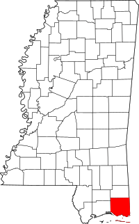 | |
| CDPs | ||
| Unincorporated communities | ||
| Ghost towns | ||
.svg.png)