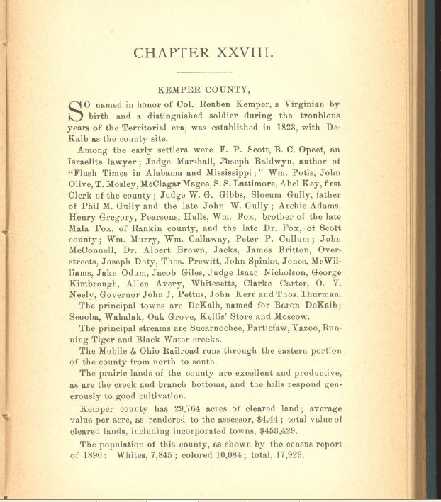
Kemper County, Mississippi
| Kemper County, Mississippi | |
|---|---|
 The Kemper Project power plant. | |
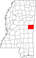 Location in the U.S. state of Mississippi | |
 Mississippi's location in the U.S. | |
| Founded | 1833 |
| Named for | Reuben Kemper |
| Seat | De Kalb |
| Largest Town | De Kalb |
| Area | |
| • Total | 767 sq mi (1,987 km2) |
| • Land | 766 sq mi (1,984 km2) |
| • Water | 0.8 sq mi (2 km2), 0.1% |
| Population | |
| • (2010) | 10,456 |
| • Density | 14/sq mi (5/km2) |
| Congressional district | 3rd |
| Time zone | Central: UTC−6/−5 |
Kemper County is a county located on the central eastern border of the U.S. state of Mississippi. As of the 2010 census, the population was 10,456.[1] Its county seat is De Kalb.[2] The county is named in honor of Reuben Kemper.[3]
The county is part of the Meridian, MS Micropolitan Statistical Area. In 2010 the Mississippi Public Service Commission approved construction of the Kemper Project, designed to use "clean coal" to produce electricity for 23 counties in the eastern part of the state. As of February 2017, it was not completed and had cost overruns. It is designed as a model project to use gasification and carbon-capture technologies at this scale.[4]
United States Senator John C. Stennis, who served from 1947 to 1988, was born in Kemper County. Another Kemper County native was Texas Ranger Captain Bill McDonald.
East Mississippi Community College is located in Kemper County in the town of Scooba, at the junction of US 45 and Mississippi Highway 16.
History
In this county the land was developed in the 19th century by white planters for cotton cultivation, based on the labor of enslaved African Americans. It continues to be largely rural. After the American Civil War and Reconstruction, racial violence increased as whites struggled to regain power over the majority population of freedmen. In the period from 1877 to 1950, Kemper County had 24 documented lynchings of African Americans, third to Hinds and Leflore counties, which had 29 and 48, respectively.[5] This form of racial terrorism was at its height in the decades around the turn of the 20th century,[5] which followed the state's disenfranchisement of most blacks in 1890 through creating barriers to voter registration. In 1890, blacks made up the majority of the county' population: 10,084 blacks to 7,845 whites.[6]
Beginning in late December 1906, there were several days of racial terror in the county. After violent incidents on the railroad between conductors and black passengers, whites attacked blacks at the rural towns of Wahalak and Scooba; by December 27, a total of 13 blacks had been killed in rioting.[7][8] The events started with a physical confrontation between a conductor and an African-American man on a Mobile & Ohio Railroad train. The conductor was cut, and he fatally shot two black men. George Simpson, another African American thought to be involved, escaped from the train. When captured in Wahalak by a posse, he killed a white constable and was quickly lynched by the other whites.[7]
As reported by The New York Times,
Not satisfied with the punishment of this man, the whites immediately set out to strike terror into the negroes, who had been getting defiant of late. They found two sons of Simpson and lynched them, filling their bodies with bullets. Two other negroes who had behaved defiantly were treated in similar fashion.[7]
Whites worried about blacks gathering to take revenge at Wahalak, where they had already been abused by lynchings, authorities called for state militia. Their commanding officer took his troops away from Wahalak while there was still unrest because he felt they were not being treated properly.[7]
By the end of the day on December 26, white men in Scooba had killed another five black men. The county sheriff arrested several whites for these murders, and called for the state militia to go to Scooba. "All the men killed at Scooba today are said to be innocent of any crime, having been shot down merely as a matter of revenge by the rough whites."[7] There had been a conflict on another train, in which a black man mortally shot a conductor, George Harrison. The yardmaster shot and killed the African American. The rioting by whites in Scooba started after Harrison died.[7] Governor James K. Vardaman went to Scooba with militia to establish control. He left a force of 20 there commanded by Adjutant General Fridge and returned to the state capital on the evening of December 27. That day the body of another murdered African-American man was found in the woods, bringing the total killed in Scooba to six.[8]
In 1934, three African-American suspects in Kemper County were repeatedly whipped in order to force them to confess to murder. In Brown v. Mississippi (1936), the U.S. Supreme Court unanimously ruled such forced confessions violated the Due Process Clause of the Fourteenth Amendment, and were inadmissible at trial.[9]
The peak of population in the county was in 1930. Mechanization of agriculture decreased the need for farm labor. From 1940 to 1970, the population declined markedly, as may be seen on the table below, as people moved to other areas for work. This was also the period of the second wave of the Great Migration of 5 million African Americans out of the South to the North and to the West Coast, where the defense industry had many jobs, beginning during World War II.[10]
Geography
According to the U.S. Census Bureau, the county has a total area of 767 square miles (1,990 km2), of which 766 square miles (1,980 km2) is land and 0.8 square miles (2.1 km2) (0.1%) is water.[11]
Major highways
Adjacent counties
- Noxubee County (north)
- Sumter County, Alabama (east)
- Lauderdale County (south)
- Neshoba County (west)
- Winston County (northwest)
Demographics
| Historical population | |||
|---|---|---|---|
| Census | Pop. | %± | |
| 1840 | 7,663 | — | |
| 1850 | 12,517 | 63.3% | |
| 1860 | 11,682 | −6.7% | |
| 1870 | 12,920 | 10.6% | |
| 1880 | 15,719 | 21.7% | |
| 1890 | 17,961 | 14.3% | |
| 1900 | 20,492 | 14.1% | |
| 1910 | 20,348 | −0.7% | |
| 1920 | 19,619 | −3.6% | |
| 1930 | 21,881 | 11.5% | |
| 1940 | 21,867 | −0.1% | |
| 1950 | 15,893 | −27.3% | |
| 1960 | 12,277 | −22.8% | |
| 1970 | 10,233 | −16.6% | |
| 1980 | 10,148 | −0.8% | |
| 1990 | 10,356 | 2.0% | |
| 2000 | 10,453 | 0.9% | |
| 2010 | 10,456 | 0.0% | |
| Est. 2016 | 9,896 | [12] | −5.4% |
| U.S. Decennial Census[13] 1790-1960[14] 1900-1990[15] 1990-2000[16] 2010-2013[1] | |||
As of the 2010 United States Census, there were 10,456 people residing in the county. 60.1% were Black or African American, 35.3% White, 3.7% Native American, 0.1% Asian, 0.1% of some other race and 0.7% of two or more races. 0.5% were Hispanic or Latino (of any race).
As of the census[17] of 2000, there were 10,453 people, 3,909 households, and 2,787 families residing in the county. The population density was 14 people per square mile (5/km²). There were 4,533 housing units at an average density of 6 per square mile (2/km²). The racial makeup of the county was 58.13% Black or African American, 39.03% White, 2.06% Native American, 0.08% Asian, 0.03% Pacific Islander, 0.11% from other races, and 0.57% from two or more races. 0.73% of the population were Hispanic or Latino of any race.
There were 3,909 households out of which 32.20% had children under the age of 18 living with them, 46.70% were married couples living together, 20.20% had a female householder with no husband present, and 28.70% were non-families. 26.40% of all households were made up of individuals and 12.60% had someone living alone who was 65 years of age or older. The average household size was 2.57 and the average family size was 3.11.
In the county, the population was spread out with 25.40% under the age of 18, 12.50% from 18 to 24, 25.20% from 25 to 44, 21.80% from 45 to 64, and 15.10% who were 65 years of age or older. The median age was 35 years. For every 100 females there were 92.20 males. For every 100 females age 18 and over, there were 88.30 males.
The median income for a household in the county was $23,998, and the median income for a family was $30,248. Males had a median income of $24,431 versus $18,199 for females. The per capita income for the county was $11,985. About 21.20% of families and 26.00% of the population were below the poverty line, including 35.30% of those under age 18 and 26.70% of those age 65 or over.
Education
Kemper County is within the service area of the East Mississippi Community College system.[18] The main campus of EMCC, including the college system's administrative headquarters, is in the Scooba Campus in Scooba.[19]
Government
The county is governed by a five-member elected Board of Supervisors, who are elected from single-member districts. The County Sheriff, Chancery Clerk, Circuit Clerk, and Tax Assessor are also elected to office.
Kemper County generally votes for candidates of the Democratic Party; the Republican presidential nominee has won it only four times in the past century.
| Year | Republican | Democratic | Third parties |
|---|---|---|---|
| 2016 | 38.3% 1,778 | 60.9% 2,827 | 0.7% 34 |
| 2012 | 35.4% 1,789 | 64.1% 3,239 | 0.5% 24 |
| 2008 | 37.1% 1,935 | 62.3% 3,256 | 0.6% 32 |
| 2004 | 45.8% 2,109 | 53.6% 2,465 | 0.6% 29 |
| 2000 | 44.9% 1,915 | 54.2% 2,311 | 0.8% 35 |
| 1996 | 38.9% 1,439 | 55.4% 2,048 | 5.7% 209 |
| 1992 | 42.0% 1,830 | 51.4% 2,243 | 6.6% 288 |
| 1988 | 50.3% 2,128 | 48.9% 2,069 | 0.9% 38 |
| 1984 | 52.8% 2,354 | 46.9% 2,089 | 0.3% 13 |
| 1980 | 41.1% 1,822 | 58.6% 2,601 | 0.4% 16 |
| 1976 | 40.4% 1,680 | 58.6% 2,436 | 1.1% 44 |
| 1972 | 75.3% 2,748 | 22.9% 837 | 1.8% 67 |
| 1968 | 5.0% 167 | 19.5% 655 | 75.5% 2,530 |
| 1964 | 92.0% 2,185 | 8.0% 191 | |
| 1960 | 11.3% 193 | 54.4% 931 | 34.3% 587 |
| 1956 | 9.5% 173 | 87.0% 1,586 | 3.5% 64 |
| 1952 | 18.9% 372 | 81.1% 1,593 | |
| 1948 | 1.9% 29 | 6.5% 98 | 91.6% 1,390 |
| 1944 | 2.7% 37 | 97.3% 1,345 | |
| 1940 | 2.9% 42 | 97.1% 1,422 | |
| 1936 | 0.5% 8 | 99.5% 1,477 | |
| 1932 | 1.9% 27 | 98.0% 1,420 | 0.1% 2 |
| 1928 | 9.0% 141 | 91.0% 1,421 | |
| 1924 | 5.8% 56 | 94.2% 911 | |
| 1920 | 8.3% 129 | 90.0% 1,397 | 1.7% 26 |
| 1916 | 6.9% 71 | 91.3% 939 | 1.8% 18 |
| 1912 | 2.2% 20 | 91.0% 828 | 6.8% 62 |
Electric power plant
In 2010, the Mississippi Public Service Commission approved the construction of a lignite coal plant in Kemper County to be financed by electricity customers in twenty-three southeastern Mississippi counties being served by Mississippi Power Company. It is designed as a model project to use gasification and carbon-capture technologies at this scale.[4]
The plant was strongly opposed by former Republican State Chairman Clarke Reed of Greenville, who favored a less-expensive natural gas-fueled plant. Reed called the project "...a horrible thing." He said it would be a political issue that could be used against Republicans for years.[21]
The Kemper Project was scheduled to open in the third quarter of 2016, more than two years behind schedule. Its cost increased to $6.6 billion—three times original cost estimate.[22][23] As of February 2017, the project was still not in service, and the cost had increased to $7.1 billion.[24]
Communities
Towns
Census-designated place
- Bogue Chitto (mostly in Neshoba County)
Unincorporated communities
- Electric Mills
- Kellis Store
- Minden
- Moscow
- Preston
- Porterville
- Union Hill
- Wahalak
Ghost town
See also
References
- 1 2 "State & County QuickFacts". United States Census Bureau. Archived from the original on July 13, 2011. Retrieved September 3, 2013.
- ↑ "Find a County". National Association of Counties. Archived from the original on 2011-05-31. Retrieved 2011-06-07.
- ↑ Gannett, Henry (1905). The Origin of Certain Place Names in the United States. Govt. Print. Off. p. 173.
- 1 2 Goldenberg, Suzanne (12 March 2014). "Can Kemper become the first US power plant to use 'clean coal'?". The Guardian. Retrieved 14 July 2014.
- 1 2 Lynching in America, 3rd edition, Supplement by County, p. 6
- ↑ Robert Lowry and Andrew McCardle, Chapter XXXVIII: "Kemper County", A History/ Mississippi, R.H. Henry & Co. Mississippi, 1891, at Mississippi GenWeb
- 1 2 3 4 5 6 "Whites in Race War Kill Blacks Blindly/ Innocent Negroes Shot in the Mississippi Trouble", New York Times, 26 December 1906; accessed 20 March 2017
- 1 2 Associated Press, "Situation in Scooba Is Now Under Full Control", Pensacola Journal (front page),The 28 December 1906; 20 March 2017
- ↑ Neil R. McMillen, Dark Journey: Black Mississippians in the Age of Jim Crow, p. 200, (University of Illinois Press, 1990)
- ↑ William H. Frey, "The New Great Migration: Black Americans' Return to the South, 1965–2000", The Brookings Institution, May 2004, pp. 1–3 Archived 2013-06-17 at the Wayback Machine., accessed 19 March 2008.
- ↑ "2010 Census Gazetteer Files". United States Census Bureau. August 22, 2012. Archived from the original on September 28, 2013. Retrieved November 4, 2014.
- ↑ "Population and Housing Unit Estimates". Retrieved June 9, 2017.
- ↑ "U.S. Decennial Census". United States Census Bureau. Archived from the original on May 12, 2015. Retrieved November 4, 2014.
- ↑ "Historical Census Browser". University of Virginia Library. Retrieved November 4, 2014.
- ↑ "Population of Counties by Decennial Census: 1900 to 1990". United States Census Bureau. Retrieved November 4, 2014.
- ↑ "Census 2000 PHC-T-4. Ranking Tables for Counties: 1990 and 2000" (PDF). United States Census Bureau. Retrieved November 4, 2014.
- ↑ "American FactFinder". United States Census Bureau. Retrieved 2008-01-31.
- ↑ "CATALOG 2007-2009 Archived 2010-12-18 at the Wayback Machine.." East Mississippi Community College. 3 (3/147). Retrieved on March 1, 2011.
- ↑ "CATALOG 2007-2009 Archived 2010-12-18 at the Wayback Machine.," East Mississippi Community College. 8 (8/147). Retrieved on March 1, 2011.
- ↑ Leip, David. "Dave Leip's Atlas of U.S. Presidential Elections". uselectionatlas.org. Retrieved 2018-03-04.
- ↑ "MS Republican founder Clarke Reed: Kemper plant "totally foolish"". yallpolitics.com. March 28, 2013. Retrieved May 12, 2014.
- ↑ Amy, Jeff (December 17, 2015). "Kemper Plant May Get More Money From Congress". Clarion-Ledger.
- ↑ "Southern Co.'s Kemper Power Plant Costs Rise Yet Again". Atlanta Business Chronicle. April 4, 2016.
- ↑ Patel, Sonal (February 23, 2017). "Kemper IGCC, Delayed Again, May Not Be Economically Viable". Power.
External links
- Kemper County Courthouse Pictures
- Memorial Foundation of the Germanna Colonies in Virginia, Inc.
- Kemper County Sheriff
Places adjacent to Kemper County, Mississippi | ||||||||||
|---|---|---|---|---|---|---|---|---|---|---|
| ||||||||||
Municipalities and communities of Kemper County, Mississippi, United States | ||
|---|---|---|
| Towns | | |
| CDP | ||
| Other communities |
| |
| Ghost town | ||
| Indian reservation | ||
| Footnotes | ‡This populated place also has portions in an adjacent county or counties | |
.svg.png)