Pike County, Mississippi
| Pike County, Mississippi | |
|---|---|
 | |
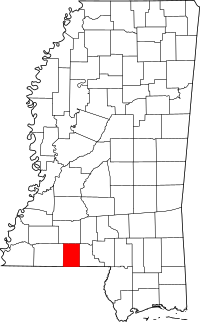 Location in the U.S. state of Mississippi | |
 Mississippi's location in the U.S. | |
| Founded | 1815 |
| Named for | Zebulon Pike |
| Seat | Magnolia |
| Largest city | McComb |
| Area | |
| • Total | 411 sq mi (1,064 km2) |
| • Land | 409 sq mi (1,059 km2) |
| • Water | 1.7 sq mi (4 km2), 0.4% |
| Population | |
| • (2010) | 40,404 |
| • Density | 99/sq mi (38/km2) |
| Congressional district | 3rd |
| Time zone | Central: UTC−6/−5 |
| Website |
www |
Pike County is a county located on the southwestern border of the U.S. state of Mississippi. As of the 2010 census, the population was 40,404.[1] The county seat is Magnolia.[2] Pike County is named for explorer Zebulon Pike.
Pike County is part of the McComb, MS Micropolitan Statistical Area.
History
Pike County was formed from Marion County by an act of the Territorial General Assembly on December 9, 1815. Holmesville was selected as the county seat on December 11, 1816; it was named in honor of Major Andrew Hunter Holmes, an army officer killed in the War of 1812. In 1873 Magnolia was voted in as the new county seat.[3] The county was devoted to agriculture and is still mostly rural.
Geography
According to the U.S. Census Bureau, the county has a total area of 411 square miles (1,060 km2), of which 409 square miles (1,060 km2) is land and 1.7 square miles (4.4 km2) (0.4%) is water.[4]
Major highways


- Mississippi Highway 570
- Mississippi Highway 584
Adjacent counties
- Lincoln County (north)
- Walthall County (east)
- Washington Parish, Louisiana (southeast)
- Tangipahoa Parish, Louisiana (south)
- Amite County (west)
Demographics
| Historical population | |||
|---|---|---|---|
| Census | Pop. | %± | |
| 1820 | 4,438 | — | |
| 1830 | 5,402 | 21.7% | |
| 1840 | 6,151 | 13.9% | |
| 1850 | 7,360 | 19.7% | |
| 1860 | 11,135 | 51.3% | |
| 1870 | 11,303 | 1.5% | |
| 1880 | 16,688 | 47.6% | |
| 1890 | 21,203 | 27.1% | |
| 1900 | 27,545 | 29.9% | |
| 1910 | 37,272 | 35.3% | |
| 1920 | 28,725 | −22.9% | |
| 1930 | 32,201 | 12.1% | |
| 1940 | 35,002 | 8.7% | |
| 1950 | 35,137 | 0.4% | |
| 1960 | 35,063 | −0.2% | |
| 1970 | 31,756 | −9.4% | |
| 1980 | 36,173 | 13.9% | |
| 1990 | 36,882 | 2.0% | |
| 2000 | 38,940 | 5.6% | |
| 2010 | 40,404 | 3.8% | |
| Est. 2016 | 39,667 | [5] | −1.8% |
| U.S. Decennial Census[6] 1790-1960[7] 1900-1990[8] 1990-2000[9] 2010-2013[1] | |||
As of the 2010 United States Census, there were 40,404 people residing in the county. 51.5% were Black or African American, 46.4% White, 0.6% Asian, 0.3% Native American, 0.5% of some other race and 0.8% of two or more races. 1.2% were Hispanic or Latino (of any race).
As of the census[10] of 2000, there were 38,940 people, 14,792 households, and 10,502 families residing in the county. The population density was 95 people per square mile (37/km²). There were 16,720 housing units at an average density of 41 per square mile (16/km²). The racial makeup of the county was 51.25% White, 47.53% Black or African American, 0.19% Native American, 0.33% Asian, 0.01% Pacific Islander, 0.20% from other races, and 0.50% from two or more races. 0.73% of the population were Hispanic or Latino of any race.
There were 14,792 households out of which 34.20% had children under the age of 18 living with them, 46.80% were married couples living together, 19.90% had a female householder with no husband present, and 29.00% were non-families. 26.50% of all households were made up of individuals and 12.00% had someone living alone who was 65 years of age or older. The average household size was 2.57 and the average family size was 3.12.
In the county, the population was spread out with 27.70% under the age of 18, 10.10% from 18 to 24, 26.00% from 25 to 44, 22.10% from 45 to 64, and 14.20% who were 65 years of age or older. The median age was 35 years. For every 100 females, there were 88.00 males. For every 100 females age 18 and over, there were 83.20 males.
The median income for a household in the county was $24,562, and the median income for a family was $29,415. Males had a median income of $27,450 versus $17,405 for females. The per capita income for the county was $14,040. About 21.50% of families and 25.30% of the population were below the poverty line, including 35.50% of those under age 18 and 19.70% of those age 65 or over.
Communities
Cities
Towns
Unincorporated communities
Politics
Pike County is a swing county in presidential elections; since 2000 it has voted Democratic thrice and Republican twice.
| Year | Republican | Democratic | Third parties |
|---|---|---|---|
| 2016 | 49.0% 8,009 | 49.2% 8,043 | 1.9% 308 |
| 2012 | 45.5% 8,181 | 53.7% 9,650 | 0.8% 143 |
| 2008 | 47.9% 8,651 | 51.4% 9,276 | 0.7% 128 |
| 2004 | 52.1% 8,660 | 47.4% 7,881 | 0.6% 91 |
| 2000 | 52.7% 7,464 | 46.2% 6,544 | 1.1% 158 |
| 1996 | 43.5% 5,403 | 50.7% 6,302 | 5.9% 730 |
| 1992 | 43.9% 6,005 | 45.9% 6,279 | 10.2% 1,395 |
| 1988 | 53.6% 7,637 | 45.9% 6,531 | 0.5% 71 |
| 1984 | 57.3% 8,254 | 42.6% 6,137 | 0.1% 20 |
| 1980 | 48.6% 6,661 | 48.8% 6,694 | 2.6% 361 |
| 1976 | 48.2% 5,659 | 48.9% 5,749 | 2.9% 343 |
| 1972 | 72.1% 6,542 | 25.7% 2,332 | 2.2% 202 |
| 1968 | 14.4% 1,460 | 28.1% 2,848 | 57.6% 5,846 |
| 1964 | 92.2% 6,418 | 7.8% 543 | |
| 1960 | 27.4% 1,467 | 23.5% 1,258 | 49.1% 2,632 |
| 1956 | 29.5% 1,210 | 41.7% 1,714 | 28.8% 1,182 |
| 1952 | 53.8% 2,908 | 46.2% 2,495 | |
| 1948 | 1.8% 69 | 5.6% 221 | 92.6% 3,650 |
| 1944 | 7.7% 248 | 92.3% 2,972 | |
| 1940 | 5.9% 185 | 93.9% 2,956 | 0.2% 6 |
| 1936 | 2.6% 86 | 97.2% 3,170 | 0.2% 5 |
| 1932 | 4.7% 118 | 94.9% 2,400 | 0.4% 10 |
| 1928 | 27.5% 920 | 72.6% 2,431 | |
| 1924 | 8.6% 197 | 71.7% 1,640 | 19.8% 452 |
| 1920 | 11.7% 153 | 84.9% 1,114 | 3.4% 45 |
| 1916 | 3.5% 53 | 95.7% 1,451 | 0.8% 12 |
| 1912 | 2.0% 24 | 86.9% 1,068 | 11.2% 137 |
See also
- National Register of Historic Places listings in Pike County, Mississippi
- Fernwood Lumber Company
- History of Pike County Mississippi 1798-1876 by Luke W. Conerly 1909
- J. J. Carter, Pike County native who served in the late 19th century in the Louisiana House of Representatives and as mayor of Minden, Louisiana[12]
References
- 1 2 "State & County QuickFacts". United States Census Bureau. Archived from the original on July 16, 2011. Retrieved September 5, 2013.
- ↑ "Find a County". National Association of Counties. Retrieved 2011-06-07.
- ↑ Pike County Mississippi 1798-1876 Pioneer Families and Confederate Soldiers, by Luke W. Conerly, 1909
- ↑ "2010 Census Gazetteer Files". United States Census Bureau. August 22, 2012. Archived from the original on September 28, 2013. Retrieved November 6, 2014.
- ↑ "Population and Housing Unit Estimates". Retrieved June 9, 2017.
- ↑ "U.S. Decennial Census". United States Census Bureau. Retrieved November 6, 2014.
- ↑ "Historical Census Browser". University of Virginia Library. Retrieved November 6, 2014.
- ↑ "Population of Counties by Decennial Census: 1900 to 1990". United States Census Bureau. Retrieved November 6, 2014.
- ↑ "Census 2000 PHC-T-4. Ranking Tables for Counties: 1990 and 2000" (PDF). United States Census Bureau. Retrieved November 6, 2014.
- ↑ "American FactFinder". United States Census Bureau. Retrieved 2008-01-31.
- ↑ Leip, David. "Dave Leip's Atlas of U.S. Presidential Elections". uselectionatlas.org. Retrieved 2018-03-03.
- ↑ C. W. Barnum. "Webster Parish, Louisiana, History and Genealogy". laahgp.genealogyvillage.com. Retrieved March 11, 2015.
Places adjacent to Pike County, Mississippi | ||||||||||
|---|---|---|---|---|---|---|---|---|---|---|
| ||||||||||
Municipalities and communities of Pike County, Mississippi, United States | ||
|---|---|---|
| Cities | | |
| Towns | ||
| Unincorporated communities | ||
.svg.png)