Jefferson County, Mississippi
| Jefferson County, Mississippi | |
|---|---|
 | |
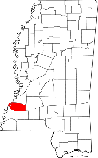 Location in the U.S. state of Mississippi | |
 Mississippi's location in the U.S. | |
| Founded | 1799 |
| Named for | Thomas Jefferson |
| Seat | Fayette |
| Largest city | Fayette |
| Area | |
| • Total | 527 sq mi (1,365 km2) |
| • Land | 520 sq mi (1,347 km2) |
| • Water | 7.3 sq mi (19 km2), 1.4% |
| Population | |
| • (2010) | 7,726 |
| • Density | 15/sq mi (6/km2) |
| Congressional district | 2nd |
| Time zone | Central: UTC−6/−5 |
| Website |
www |
Jefferson County is a county located in the U.S. state of Mississippi; its western border is formed by the Mississippi River. As of the 2010 census, the population was 7,726,[1] making it the third-least populous county in Mississippi. Its county seat is Fayette.[2] The county is named for U.S. President Thomas Jefferson.[3]
Originally developed as cotton plantations in the antebellum era, the rural county has struggled with a declining economy and reduced population since the mechanization of agriculture and urbanization of other areas. In 2014 its estimated population of 7599 was roughly one-third of the population peak in 1900. Within the United States, in 2009 rural Jefferson County had the highest percentage of African-Americans of any county. It was the fourth-poorest county in the nation.[4]
Geography
According to the U.S. Census Bureau, the county has a total area of 527 square miles (1,360 km2), of which 520 square miles (1,300 km2) is land and 7.3 square miles (19 km2) (1.4%) is water.[5]
Major highways
Adjacent counties
- Claiborne County (north)
- Copiah County (northeast)
- Lincoln County (southeast)
- Franklin County (south)
- Adams County (southwest)
- Tensas Parish, Louisiana (west)
National protected areas
- Homochitto National Forest (part)
- Natchez Trace Parkway (part)
Demographics
| Historical population | |||
|---|---|---|---|
| Census | Pop. | %± | |
| 1800 | 2,940 | — | |
| 1810 | 4,001 | 36.1% | |
| 1820 | 6,822 | 70.5% | |
| 1830 | 9,755 | 43.0% | |
| 1840 | 11,650 | 19.4% | |
| 1850 | 13,193 | 13.2% | |
| 1860 | 15,349 | 16.3% | |
| 1870 | 13,848 | −9.8% | |
| 1880 | 17,314 | 25.0% | |
| 1890 | 18,947 | 9.4% | |
| 1900 | 21,292 | 12.4% | |
| 1910 | 18,221 | −14.4% | |
| 1920 | 15,946 | −12.5% | |
| 1930 | 14,291 | −10.4% | |
| 1940 | 13,969 | −2.3% | |
| 1950 | 11,306 | −19.1% | |
| 1960 | 10,142 | −10.3% | |
| 1970 | 9,295 | −8.4% | |
| 1980 | 9,181 | −1.2% | |
| 1990 | 8,653 | −5.8% | |
| 2000 | 9,740 | 12.6% | |
| 2010 | 7,726 | −20.7% | |
| Est. 2016 | 7,297 | [6] | −5.6% |
| U.S. Decennial Census[7] 1790-1960[8] 1900-1990[9] 1990-2000[10] 2010-2013[1] | |||
As of the 2010 United States Census, there were 7,726 people residing in the county. 85.7% were Black or African American, 13.7% White, 0.2% Native American and 0.3% of two or more races. 0.4% were Hispanic or Latino (of any race).
As of the census[11] of 2000, there were 9,740 people, 3,308 households, and 2,338 families residing in the county. The population density was 19 people per square mile (7/km²). There were 3,819 housing units at an average density of 7 per square mile (3/km²). The racial makeup of the county was 13.06% White, 86.49% Black or African American, 0.08% Native American, 0.10% Asian, 0.01% Pacific Islander, 0.02% from other races, and 0.24% from two or more races. 0.66% of the population were Hispanic or Latino of any race. Jefferson County has the highest percentage of black residents of any U.S. county.
There were 3,308 households out of which 36.60% had children under the age of 18 living with them, 36.00% were married couples living together, 28.50% had a female householder with no husband present, and 29.30% were non-families. 27.10% of all households were made up of individuals and 10.10% had someone living alone who was 65 years of age or older. The average household size was 2.75 and the average family size was 3.36.
In the county, the population was much younger than the national average with 28.80% under the age of 18, 12.10% from 18 to 24, 28.50% from 25 to 44, 19.60% from 45 to 64, and 10.90% who were 65 years of age or older. The median age was 32 years. For every 100 females there were 99.00 males. For every 100 females age 18 and over, there were 99.00 males.
The median income for a household in the county was $18,447, and the median income for a family was $23,188. Males had a median income of $25,726 versus $18,000 for females. The per capita income for the county was $9,709. About 32.50% of families and 36.00% of the population were below the poverty line, including 46.00% of those under age 18 and 34.40% of those age 65 or over.
In 2009, Jefferson County has the lowest per capita income in Mississippi and the 17th lowest in the United States.[4]
Education
Jefferson County School District operates public schools.
Communities
City
- Fayette (county seat)
Unincorporated communities
Ghost towns or defunct
- Ashland
- Gum Ridge
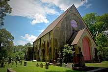
- Old Greenville, original county seat (c 1799–1825); on the Natchez Trace
- Rodney
- Selsertown, another Natchez Trace town
- Uniontown
Politics
| Year | Republican | Democratic | Third parties |
|---|---|---|---|
| 2016 | 12.7% 490 | 86.5% 3,337 | 0.9% 33 |
| 2012 | 10.6% 468 | 89.1% 3,951 | 0.3% 14 |
| 2008 | 12.3% 551 | 86.7% 3,883 | 1.0% 44 |
| 2004 | 18.2% 630 | 81.3% 2,821 | 0.5% 18 |
| 2000 | 17.6% 600 | 81.8% 2,786 | 0.7% 22 |
| 1996 | 15.7% 489 | 81.2% 2,531 | 3.2% 99 |
| 1992 | 16.0% 562 | 79.4% 2,796 | 4.7% 164 |
| 1988 | 20.6% 702 | 79.2% 2,693 | 0.2% 6 |
| 1984 | 21.9% 856 | 77.9% 3,049 | 0.2% 7 |
| 1980 | 20.2% 751 | 77.1% 2,871 | 2.7% 102 |
| 1976 | 22.8% 782 | 74.8% 2,562 | 2.4% 82 |
| 1972 | 43.4% 1,131 | 55.9% 1,457 | 0.8% 20 |
| 1968 | 4.4% 147 | 62.8% 2,121 | 32.9% 1,112 |
| 1964 | 94.8% 1,258 | 5.2% 69 | |
| 1960 | 12.5% 137 | 20.9% 229 | 66.5% 728 |
| 1956 | 19.7% 189 | 45.7% 440 | 34.6% 333 |
| 1952 | 53.1% 610 | 46.9% 539 | 0.0% 0 |
| 1948 | 1.4% 14 | 1.5% 15 | 97.1% 967 |
| 1944 | 3.2% 25 | 96.8% 766 | |
| 1940 | 0.9% 7 | 99.1% 801 | |
| 1936 | 1.0% 9 | 98.9% 884 | 0.1% 1 |
| 1932 | 3.1% 24 | 96.3% 753 | 0.6% 5 |
| 1928 | 7.1% 63 | 93.0% 830 | |
| 1924 | 9.1% 50 | 90.9% 497 | |
| 1920 | 3.2% 14 | 96.6% 430 | 0.2% 1 |
| 1916 | 0.7% 3 | 99.1% 456 | 0.2% 1 |
| 1912 | 0.5% 2 | 94.7% 408 | 4.9% 21 |
Notable People
- Abijah Hunt, merchant who lived in Old Greenville during the Territorial Period, and owned a chain of stores and public cotton gins along the Natchez Trace[13]
- David Hunt, Antebellum planter who lived on Woodlawn Plantation in Jefferson County, and became one of 12 planter millionaires in the Natchez District before the American Civil War.
- Zachary Taylor, U.S. President, planter, and soldier who often stayed on his plantation, Cypress Grove in Jefferson County, between 1840 and 1848.
See also
| Wikimedia Commons has media related to Jefferson County, Mississippi. |
References
- 1 2 "State & County QuickFacts". United States Census Bureau. Archived from the original on July 12, 2011. Retrieved September 3, 2013.
- ↑ "Find a County". National Association of Counties. Archived from the original on 2011-05-31. Retrieved 2011-06-07.
- ↑ Gannett, Henry (1905). The Origin of Certain Place Names in the United States. Govt. Print. Off. p. 168.
- 1 2 "King: They'll take small victories in struggling Mississippi county." CNN. 25 September 2009, Retrieved September 26, 2009.
- ↑ "2010 Census Gazetteer Files". United States Census Bureau. August 22, 2012. Archived from the original on September 28, 2013. Retrieved November 4, 2014.
- ↑ "Population and Housing Unit Estimates". Retrieved June 9, 2017.
- ↑ "U.S. Decennial Census". United States Census Bureau. Archived from the original on May 12, 2015. Retrieved November 4, 2014.
- ↑ "Historical Census Browser". University of Virginia Library. Retrieved November 4, 2014.
- ↑ "Population of Counties by Decennial Census: 1900 to 1990". United States Census Bureau. Retrieved November 4, 2014.
- ↑ "Census 2000 PHC-T-4. Ranking Tables for Counties: 1990 and 2000" (PDF). United States Census Bureau. Retrieved November 4, 2014.
- ↑ "American FactFinder". United States Census Bureau. Retrieved 2008-01-31.
- ↑ Leip, David. "Dave Leip's Atlas of U.S. Presidential Elections". uselectionatlas.org. Retrieved 2018-03-04.
- ↑ A Guide to the Abijah Hunt Papers, 1800-1821, 1880, The University of Texas at Austin: Briscoe Center for American History
Places adjacent to Jefferson County, Mississippi | ||||||||||
|---|---|---|---|---|---|---|---|---|---|---|
| ||||||||||
Municipalities and communities of Jefferson County, Mississippi, United States | ||
|---|---|---|
| City | | |
| Unincorporated communities | ||
| Ghost towns | ||
.svg.png)