Moss Point, Mississippi
| Moss Point, Mississippi | |
|---|---|
| City | |
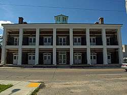 Moss Point City Hall | |
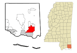 Location of Moss Point in the state of Mississippi | |
 Moss Point, Mississippi Location in the United States | |
| Coordinates: 30°24′42″N 88°32′04″W / 30.411744°N 88.534355°WCoordinates: 30°24′42″N 88°32′04″W / 30.411744°N 88.534355°W | |
| Country | United States |
| State | Mississippi |
| County | Jackson |
| Incorporated | 1901 (as a city) |
| Government | |
| • Mayor | Mario King (D) |
| Area | |
| • Total | 26.6 sq mi (68.8 km2) |
| • Land | 24.2 sq mi (62.6 km2) |
| • Water | 2.4 sq mi (6.3 km2) |
| Elevation | 16 ft (5 m) |
| Population (2010) | |
| • Total | 13,704 |
| • Estimate (2016)[1] | 13,570 |
| • Density | 562/sq mi (216.9/km2) |
| Time zone | UTC-6 (CST) |
| • Summer (DST) | UTC-5 (CDT) |
| ZIP codes | 39562, 39563, 39581 |
| Area code(s) | 228 |
| FIPS code | 28-49240 |
| GNIS feature ID | 0673878 |
| Website |
cityofmosspoint |
Moss Point is a city in Jackson County, Mississippi, United States. The population was 13,704 at the 2010 census,[2] down from 17,653 at the 2000 census. On August 29, 2005, Moss Point was hit by the strong east side of Hurricane Katrina, and much of the city was flooded or destroyed (see details below).
Geography
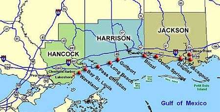
Moss Point is in southeastern Jackson County, on the east side of the Pascagoula River. It is bordered to the south by the city of Pascagoula, the county seat, and to the north by unincorporated Escatawpa. The Escatawpa River flows east-west through the city into the Pascagoula River.
U.S. Route 90 forms the southeast boundary of Moss Point, leading southwest into Pascagoula and northeast to Interstate 10, which runs through the northern part of the Moss Point city limits. I-10 leads west 22 miles (35 km) to the Biloxi area and northeast 36 miles (58 km) to Mobile, Alabama. Mississippi Highways 63 and 613 (Main Street) are north-south roads through Moss Point. Highway 63 leads south to US-90 and north 38 miles (61 km) to Lucedale, while Highway 613 leads south 4 miles (6 km) to the center of Pascagoula and north 5 miles (8 km) to Escatawpa.
Moss Point has a total area of 26.6 square miles (68.8 km2), of which 24.2 square miles (62.6 km2) are land and 2.4 square miles (6.3 km2), or 9.11%, are water.[2]
Demographics
| Historical population | |||
|---|---|---|---|
| Census | Pop. | %± | |
| 1870 | 440 | — | |
| 1880 | 1,333 | 203.0% | |
| 1910 | 3,054 | — | |
| 1920 | 3,340 | 9.4% | |
| 1930 | 2,453 | −26.6% | |
| 1940 | 3,042 | 24.0% | |
| 1950 | 3,782 | 24.3% | |
| 1960 | 6,631 | 75.3% | |
| 1970 | 19,321 | 191.4% | |
| 1980 | 18,998 | −1.7% | |
| 1990 | 17,837 | −6.1% | |
| 2000 | 17,653 | −1.0% | |
| 2010 | 13,704 | −22.4% | |
| Est. 2016 | 13,570 | [1] | −1.0% |
| U.S. Decennial Census[3] | |||
As of the census of 2000, there were 17,653 people, 6,714 households, and 5,228 families residing in the city. The population density was 634.0 people per square mile (344.8/km²). There were 6,237 housing units at an average density of 249.4 per square mile (96.3/km²). The racial makeup of the city was 28.04% White, 70.56% African American, 0.15% Native American, 0.21% Asian, 0.03% Pacific Islander, 0.44% from other races, and 0.57% from two or more races. Hispanic or Latino of any race were 1.00% of the population.
There were 5,714 households out of which 31.6% had children under the age of 18 living with them, 44.7% were married couples living together, 23.7% had a female householder with no husband present, and 26.0% were non-families. 22.8% of all households were made up of individuals and 8.6% had someone living alone who was 65 years of age or older. The average household size was 2.75 and the average family size was 3.21.
In the city, the population was spread out with 26.8% under the age of 18, 9.5% from 18 to 24, 25.8% from 25 to 44, 25.3% from 45 to 64, and 12.6% who were 65 years of age or older. The median age was 37 years. For every 100 females, there were 91.2 males. For every 100 females age 18 and over, there were 87.4 males.
The median income for a household in the city was $32,075, and the median income for a family was $37,712. Males had a median income of $31,126 versus $20,550 for females. The per capita income for the city was $15,537. About 15.8% of families and 17.8% of the population were below the poverty line, including 23.2% of those under age 18 and 17.3% of those age 65 or over.
Education
The city is served by the Moss Point School District.
Crime
| Moss Point | |
|---|---|
| Crime rates* (2012) | |
| Violent crimes | |
| Homicide | 0 |
| Robbery | 29 |
| Aggravated assault | 63 |
| Total violent crime | 104 |
| Property crimes | |
| Burglary | 314 |
| Larceny-theft | 368 |
| Motor vehicle theft | 54 |
| Arson | 2 |
| Total property crime | 736 |
|
Notes *Number of reported crimes per 100,000 population. 2012 population: 13,756 Source: 2012 FBI UCR Data | |
Crime statistics provided are from 2010. There were 16 rapes, 31 robberies, 71 assaults, 411 burglaries, 311 larceny counts and 70 auto thefts per year. City-data.com crime index average for 3 years is 615.8 per 100,000. The US average is 309.2.[4]
Hurricane Katrina
On August 29, 2005, Moss Point was hit by the strong eastern side of Hurricane Katrina, when it passed 30 miles (48 km) east of central New Orleans with minimal gale-force winds. However, on the east side of Hurricane Katrina, much of Moss Point was flooded or destroyed in one day, by the strong hurricane-force winds which lasted several hours and a storm surge exceeding 20 feet (6.1 m) in some sections.[5]
Sister city
In the wake of Hurricane Katrina, Burlington, Vermont, became the sister city of Moss Point and provided much-needed aid to the city.[6]
Notable people
- Verlon Biggs, NFL football player, Hall of Famer, and former defensive end for the Washington Redskins from 1965–71 and the New York Jets from 1971–80
- Damarius Bilbo, NFL football player and sports agent, graduated from Moss Point High School in 2001
- Devin Booker, NBA basketball player
- Melvin Booker, former NBA basketball player, father of Devin Booker
- John Brock, CEO of Coca-Cola Enterprises (graduated from Moss Point High School in 1967)[7]
- Ray Costict, former linebacker for the New England Patriots from 1977–79
- Ken Farragut, NFL and Ole Miss Hall of Fame football player
- Don Hultz, NFL football player
- Robert C. Khayat, Chancellor of the University of Mississippi
- David Thomas Roberts, composer and musician
- Tony Sipp, Major League Baseball player
- George Wonsley, NFL football player
- Nathan Wonsley, NFL football player
See also
Notes
- 1 2 "Population and Housing Unit Estimates". Retrieved June 9, 2017.
- 1 2 "Geographic Identifiers: 2010 Census Summary File 1 (G001): Moss Point city, Mississippi". American Factfinder. U.S. Census Bureau. Retrieved August 3, 2018.
- ↑ United States Census Bureau. "Census of Population and Housing". Retrieved October 23, 2013.
- ↑ City-data.com. "Crime rate in Moss Point, Mississippi (MS): murders, rapes, robberies, assaults, burglaries, thefts, auto thefts, arson, law enforcement employees, police officers, crime map". Retrieved October 23, 2013.
- ↑ Gary Tuchman, Transcript of "Anderson Cooper 360 Degrees" (2006-08-29) 19:00 ET, CNN, CNN-ACooper082906 GARY TUCHMAN, CNN Correspondent: Responds to Anderson Cooper that it felt like it would never end, saying winds were at least 100 miles per hour in Gulfport for seven hours, between about 7:00 a.m. and 2:00 p.m. For another five or six hours, on each side of that, they had hurricane-force winds over 75 miles per hour; much of the city of Gulfport, Mississippi, in Harrison County of 71,000 was then under water.
- ↑ Moss Point receives aid from Burlington, VT; become sister cities Archived 2008-06-07 at the Wayback Machine.
- ↑ John Brock, "local boy", makes it to the big time"
External links
Municipalities and communities of Jackson County, Mississippi, United States | ||
|---|---|---|
| Cities | 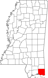 | |
| CDPs | ||
| Unincorporated communities | ||
| Ghost towns | ||
.svg.png)