International Falls, Minnesota
| International Falls, Minnesota | |
|---|---|
| City | |
 | |
|
Nickname(s): Icebox of the Nation, Frostbite Falls | |
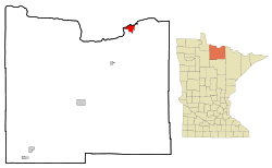 Location of International Falls within Koochiching County and the U.S. state of Minnesota | |
| Coordinates: 48°35′30″N 93°24′19″W / 48.59167°N 93.40528°WCoordinates: 48°35′30″N 93°24′19″W / 48.59167°N 93.40528°W[1] | |
| Country | United States |
| State | Minnesota |
| County | Koochiching |
| Area[2] | |
| • Total | 6.53 sq mi (16.91 km2) |
| • Land | 6.42 sq mi (16.63 km2) |
| • Water | 0.11 sq mi (0.28 km2) |
| Elevation[1] | 1,131 (344m) ft (342 m) |
| Population (2010)[3] | |
| • Total | 6,424 |
| • Estimate (2016)[4] | 6,068 |
| • Density | 980/sq mi (380/km2) |
| Time zone | UTC-6 (CST) |
| • Summer (DST) | UTC-5 (CDT) |
| ZIP code | 56649 |
| Area code | 218 Exchanges: 283, 285 |
| FIPS code | 27-31040 [1] |
| GNIS feature ID | 0645435 [1] |
| Website | City Website |
 |
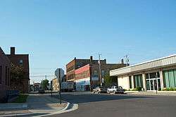
| International Falls, on the south bank of Rainy River, which serve as the US/Canada border. |
International Falls is a city in and the county seat of Koochiching County, Minnesota, United States.[1] The population was 6,424 at the 2010 census.[5]
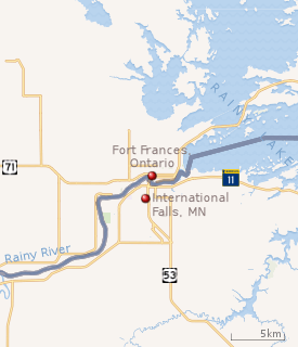
International Falls is located on the Rainy River directly across from Fort Frances, Ontario, Canada. The two cities are connected by the Fort Frances – International Falls International Bridge. Voyageurs National Park is located 11 miles east of International Falls. There is a major U.S. Customs and Border Protection Port of Entry on the International Falls side of the toll bridge, and a Canadian Customs entry point on the north side of the bridge.
International Falls is nicknamed "Icebox of the Nation", with 109.4 days per year with a high temperature below 32 °F (0 °C).
History
The area now known as International Falls was inhabited by many Indigenous peoples. The International Falls area was well known to explorers, missionaries, and voyagers as early as the 17th century, it was not until April 1895 the community was platted by a teacher and preacher L. A. Ogaard for the Koochiching Company and named the community Koochiching. The word "Koochiching" comes from either Ojibwe word Gojijiing or Cree Kocicīhk, both meaning "at the place of inlets," referring to the neighboring Rainy Lake and River. The European inhabitants gave the names Rainy Lake and Rainy River to the nearby bodies of water because of the mist-like rain present at the falls where the lake flowed into the river.
On August 10, 1901, the village was incorporated and two years later its name was changed to International Falls in recognition of the river's role as a border between the United States and Canada. It was incorporated as a city in 1909.[6]
Realizing the potential for water power and mills in the area, industrialist E.W. Backus, president of the Minnesota and Ontario Paper Company in the early 20th century, built a dam on the Rainy River to power the company's mills. Purchased by Boise Cascade Corporation in 1965, and sold to an investment group in 2003, the company remains the largest business and employer in the area. In 2013 Boise laid off 394 employees and closed down a paper machine. It then sold to Packaging Corporation of America (PCA).
Geography
According to the United States Census Bureau, the city has a total area of 6.53 square miles (16.91 km2), of which 6.42 square miles (16.63 km2) is land and 0.11 square miles (0.28 km2) is water.[2]
Climate
International Falls, with its relatively central position in the North American continent, has a humid continental climate (Köppen Dfb), with long, bitterly cold winters and humid warm summers, and is part of USDA Plant hardiness zone 3a.[7] January averages 4.4 °F (−15.3 °C), and lows reach 0 °F (−18 °C) on average of 58 nights annually.[8] Highs only reach the freezing point or above an average of 16.7 days in the months of December, January, and February; and in combination with an average seasonal snowfall of 71.0 in (180 cm), snow depths of 5 in (13 cm) or more is seen on a majority of days from December to March, inclusive.[9] Spring, and more especially autumn, are short but mild transition seasons. July averages 65.2 °F (18.4 °C), with highs reaching 90 °F (32 °C) an average of only 3.2 days annually, and in close to 40% of years, the temperature does not rise that high. Precipitation averages about 24.2 in (610 mm) per year, and is concentrated in the warmer months. The average window for freezing temperatures is September 14 thru May 26, allowing a frost-free period of 110 days;[8] measurable snowfall (≥0.1 in or 0.25 cm) arrives on average on October 18 and departs April 22.[8] The all-time record high temperature is 103 °F (39 °C), set on July 22, 1923, while the all-time record low is −55 °F (−48 °C), set on January 6, 1909, a range of 158 °F (88 °C); the record cold maximum is −29 °F (−34 °C), set on the same day as the record low, while, conversely, the record warm minimum is 79 °F (26 °C) is July 16, 1898.[8]
| Climate data for International Falls, Minnesota (Falls International Airport), 1981–2010 normals,[lower-alpha 1] extremes 1897–present | |||||||||||||
|---|---|---|---|---|---|---|---|---|---|---|---|---|---|
| Month | Jan | Feb | Mar | Apr | May | Jun | Jul | Aug | Sep | Oct | Nov | Dec | Year |
| Record high °F (°C) | 49 (9) |
58 (14) |
79 (26) |
93 (34) |
95 (35) |
101 (38) |
103 (39) |
96 (36) |
96 (36) |
88 (31) |
73 (23) |
56 (13) |
103 (39) |
| Mean maximum °F (°C) | 38.3 (3.5) |
42.7 (5.9) |
55.2 (12.9) |
74.5 (23.6) |
83.6 (28.7) |
86.7 (30.4) |
89.5 (31.9) |
88.4 (31.3) |
83.4 (28.6) |
72.8 (22.7) |
54.7 (12.6) |
38.0 (3.3) |
91.6 (33.1) |
| Average high °F (°C) | 15.4 (−9.2) |
22.0 (−5.6) |
34.7 (1.5) |
51.5 (10.8) |
64.8 (18.2) |
73.2 (22.9) |
77.8 (25.4) |
75.9 (24.4) |
65.4 (18.6) |
51.1 (10.6) |
33.7 (0.9) |
19.0 (−7.2) |
48.8 (9.3) |
| Average low °F (°C) | −6.6 (−21.4) |
−1.3 (−18.5) |
12.5 (−10.8) |
27.1 (−2.7) |
38.7 (3.7) |
48.4 (9.1) |
52.6 (11.4) |
50.7 (10.4) |
41.8 (5.4) |
31.0 (−0.6) |
17.4 (−8.1) |
0.4 (−17.6) |
26.2 (−3.2) |
| Mean minimum °F (°C) | −32.5 (−35.8) |
−28.6 (−33.7) |
−14.2 (−25.7) |
11.3 (−11.5) |
24.8 (−4) |
34.0 (1.1) |
41.2 (5.1) |
38.2 (3.4) |
27.5 (−2.5) |
16.9 (−8.4) |
−2.8 (−19.3) |
−26.8 (−32.7) |
−36.7 (−38.2) |
| Record low °F (°C) | −55 (−48) |
−48 (−44) |
−38 (−39) |
−14 (−26) |
8 (−13) |
23 (−5) |
32 (0) |
27 (−3) |
19 (−7) |
2 (−17) |
−32 (−36) |
−41 (−41) |
−55 (−48) |
| Average precipitation inches (mm) | 0.62 (15.7) |
0.57 (14.5) |
0.95 (24.1) |
1.53 (38.9) |
2.86 (72.6) |
3.92 (99.6) |
3.70 (94) |
2.81 (71.4) |
2.99 (75.9) |
2.08 (52.8) |
1.38 (35.1) |
0.81 (20.6) |
24.22 (615.2) |
| Average snowfall inches (cm) | 15.0 (38.1) |
10.8 (27.4) |
7.6 (19.3) |
6.4 (16.3) |
0.2 (0.5) |
0 (0) |
0 (0) |
0 (0) |
0.1 (0.3) |
2.2 (5.6) |
13.7 (34.8) |
15.0 (38.1) |
71.0 (180.3) |
| Average precipitation days (≥ 0.01 in) | 9.3 | 7.9 | 8.8 | 8.7 | 12.4 | 13.7 | 11.9 | 11.0 | 11.9 | 11.7 | 10.0 | 10.7 | 128.0 |
| Average snowy days (≥ 0.1 in) | 12.4 | 9.9 | 7.8 | 3.3 | 0.5 | 0 | 0 | 0 | 0.2 | 2.4 | 9.6 | 12.8 | 58.9 |
| Average relative humidity (%) | 70.8 | 67.4 | 65.7 | 61.1 | 61.3 | 68.6 | 71.2 | 74.8 | 77.1 | 74.2 | 78.8 | 77.1 | 70.7 |
| Source: NOAA (relative humidity 1961–1990)[8][9][10] | |||||||||||||
Icebox of the Nation
International Falls has long promoted itself as the "Icebox of the Nation"; however, the trademark for the slogan has been challenged on several occasions by the small town of Fraser, Colorado. Officials from Fraser claimed usage since 1956, International Falls since 1948. The two towns came to an agreement in 1986, when International Falls paid Fraser $2,000 to relinquish its "official" claim. However, in 1996, International Falls inadvertently failed to renew its federal trademark, although it had kept its state trademark up to date. Fraser then filed to gain the federal trademark.[11] International Falls submitted photographic proof that its 1955 Pee Wee hockey team traveled to Boston, Massachusetts with the slogan.[12] After several years of legal battles, the United States Patent and Trademark Office officially registered the slogan with International Falls on January 29, 2008, Registration Number 3375139.[13] Only a few days after announcing its success in the trademark battle, International Falls had a daily record low temperature of −40 °F (−40 °C), beating a previous record of −37 °F (−38.3 °C) in 1967.[14]
Besides Fraser, there are still many towns that are smaller and annually overall colder than International Falls, many of these being mountain communities in the Rockies, as well as several in northern Minnesota. International Falls is still called the "Icebox of the Nation" after winning the claim against Fraser in court.[15] One thing that does help or hinder International Falls is that Fraser is located within the Rocky Mountains, which would help to depress low temperatures while International Falls is located on relatively flat land, which takes longer to cool on warm summer nights. Also, while sub−freezing temperatures are very common at high elevation, valley sites in the Rockies during the winter, maximum temperatures that remain sub−freezing are quite rare, while at International Falls and much of the upper (Northern) Midwest they are of relatively frequent occurrence. This is reflected by the average monthly temperatures during the winter months.
Demographics
| Historical population | |||
|---|---|---|---|
| Census | Pop. | %± | |
| 1910 | 1,487 | — | |
| 1920 | 3,448 | 131.9% | |
| 1930 | 5,036 | 46.1% | |
| 1940 | 5,626 | 11.7% | |
| 1950 | 6,269 | 11.4% | |
| 1960 | 6,778 | 8.1% | |
| 1970 | 6,439 | −5.0% | |
| 1980 | 5,611 | −12.9% | |
| 1990 | 8,324 | 48.4% | |
| 2000 | 6,703 | −19.5% | |
| 2010 | 6,424 | −4.2% | |
| Est. 2017 | 5,992 | [16] | −6.7% |
| U.S. Decennial Census[17] 2013 Estimate[18] | |||
As of 2000 the median income for a household in the city was $29,908, and the median income for a family was $41,458. Males had a median income of $41,584 versus $20,053 for females. The per capita income for the city was $19,171. About 10.0% of families and 14.5% of the population were below the poverty line, including 20.5% of those under age 18 and 12.3% of those age 65 or over.
2010 census
As of the census[3] of 2010, there were 6,424 people, 2,903 households, and 1,645 families residing in the city. The population density was 1,000.6 inhabitants per square mile (386.3/km2). There were 3,157 housing units at an average density of 491.7 per square mile (189.8/km2). The racial makeup of the city was 93.3% White, 1.0% African American, 2.5% Native American, 0.2% Asian, 0.1% from other races, and 2.8% from two or more races. Hispanic or Latino of any race were 1.1% of the population.
There were 2,903 households of which 26.6% had children under the age of 18 living with them, 39.1% were married couples living together, 12.1% had a female householder with no husband present, 5.5% had a male householder with no wife present, and 43.3% were non-families. 37.4% of all households were made up of individuals and 16.4% had someone living alone who was 65 years of age or older. The average household size was 2.16 and the average family size was 2.80.
The median age in the city was 42.4 years. 21.9% of residents were under the age of 18; 8.6% were between the ages of 18 and 24; 22.4% were from 25 to 44; 27.3% were from 45 to 64; and 19.8% were 65 years of age or older. The gender makeup of the city was 48.1% male and 51.9% female.
2000 census
As of the census[19] of 2000, there were 6,703 people, 2,959 households, and 1,751 families residing in the city. The racial makeup of the city was 96.8% White, 0.5% African American, 3.7% Native American, 0.3% Asian, 0.2% from other races, and 1.5% from two or more races. Hispanic or Latino of any race were 0.7% of the population.
There were 2,959 households of which 27.6% had children under the age of 18 living with them, 44% were married couples living together, 11.4% had a female householder with no husband present and 40.8% were non-families. 36.5% of all households were made up of individuals and 18.2% had someone living alone who was 65 years of age or older. The average household size was 2.20 and the average family size was 2.85.
The median age in the city was 40.5 years. 23.3% of residents were under the age of 18; 5.1% were between the ages of 20 and 24; 25.5% were from 25 to 44; 22.3% were from 45 to 64; and 20.7% were 65 years of age or older. The gender makeup of the city was 47.7% male and 52.3% female.
Local media
- Radio
International Falls is home to two commercial radio stations; KGHS (1230 AM) and KSDM (104.1 FM), owned and operated by Red Rock Radio; two non-commercial radio stations in International Falls, KBHW (99.5 FM) and KXBR (91.9 FM), owned and operated by Heartland Christian Broadcasters, Inc.; and two Minnesota Public Radio stations from Bemidji, KNBJ (88.1 FM; News) and KCRB-FM (97.7 FM; Classical).
The local Icebox Radio Theater produces radio drama broadcasts on 106.9 FM, with a power output one watt.
CFOB-FM (93.1 FM) also serves International Falls, and is licensed to Fort Frances, Ontario.
- Television
International Falls is part of the Duluth television market, and is served by the following repeaters:
| OTA channel | PSIP | Channel Type | Call sign | Network | Rebroadcasts | Owner |
|---|---|---|---|---|---|---|
| 38 | 38.1 | Digital | K38MM-D | Three Angels Broadcasting Network | Via satellite | Three Angels Broadcasting Network |
| 45 | n/a | Analog | K45JD | Fox | KQDS-TV | Red River Broadcasting |
| 47 | 11.1-2, 3.1-2 | Digital | K47NW-D | NBC, The CW, CBS, MyNetworkTV | KRII (NBC, MyNetworkTV) KDLH (CBS, The CW) |
Koochiching County government |
| 49 | 13.1-2 | Digital | K49BU-D | ABC, Me-TV | WIRT-DT | Koochiching County government |
| 51 | 31.1-4 | Digital | K51CM-D | PBS, PBS Satellite Service, Create, Minnesota Channel | WRPT | Koochiching County government |
Local cable television service is offered by Midcontinent Communications.
- Newspaper
The local newspaper is The Journal.
Culture
The Backus Community Center opened in 2002 and serves as one of the cultural centers of International Falls. Each year, the Backus Performing Arts Series presents a number of musical and stage productions to the local community.[22]
The Borealis Bards community theatre group has staged a number of productions since its founding in 2014, including 2015's production of Alice In Wonderland.[23]
The International Falls post office contains a mural, Early Lodging in Koochichin Falls, painted by Lucia Wiley. Federally commissioned murals were produced from 1934 to 1943 in the United States through the Section of Painting and Sculpture, later called the Section of Fine Arts, of the Treasury Department. The WPA was the largest and most ambitious American New Deal agency, employing individuals to carry out public works projects.[24]
Transportation
Falls International Airport (IATA code: INL, ICAO code: KINL) is a public airport located just south of the city. The airport has two runways. It is mostly used for general aviation but is also served by a single commercial airline, Delta Air Lines' Delta Connection, which has two daily flights to Minneapolis–Saint Paul International Airport.
The Minnesota, Dakota and Western Railway operates a 4 mi (6.4 km) line between International Falls and Ranier.[25]
Major highways
The following routes are located within the city of International Falls.
References in popular culture
A Sears Diehard car battery commercial was filmed in International Falls in the 1970s, playing on the city's extremely cold winter climate to promote the longevity and effectiveness of the product. It led to a parody ad - aired several times in the first (1975) season of Saturday Night Live - promoting a geriatric product.
The fictional Minnesota small town of Frostbite Falls, which was the hometown of cartoon characters Rocket "Rocky" J. Squirrel and Bullwinkle J. Moose of The Rocky and Bullwinkle Show, was a spoof of the real-life International Falls. The fictional town was located in Koochiching County as well.
Notable people
- Edward Backus, industrialist
- Tammy Bakker, PTL The 700 Club
- Dean Blais, hockey coach, University of Nebraska, Omaha, NCHC
- Bill Borcher, University of Oregon head basketball coach 1951-1956
- Kevin Constantine, hockey coach, NHL, IHL
- Jim Crotty, pro football player, Washington Redskins
- Mike Curran, hockey player, 1972 Winter Olympics silver medal
- Richard Dougherty, Minnesota Gopher Hall of Fame hockey, silver medal 1956 Olympic Games
- Arlys Johnson-Maxwell, weightlifter Senior World Champion 1987
- Bob Mason, Goalie NHL 1984-1991, coach of Minnesota Wild
- Bronko Nagurski, football player, member of the College Football Hall of Fame and the Pro Football Hall of Fame
- Bronko Nagurski, Jr., football player for Notre Dame and in Canadian Football League
- Ernest Oberholtzer, explorer, author, conservationist
- Gary Sampson, hockey player, Washington Capitals
- Neil Sheehy, hockey player, Calgary Flames Hartford Whalers and Washington Capitals NHL Hockey Agent
- Timothy Sheehy, hockey player, United States Hockey Hall of Fame, silver medalist and captain of 1972 USA Team in Winter Olympics Sapporo, Japan
- Frank Youso, NFL player, New York Giants, Oakland Raiders
See also
Notes
- ↑ Mean monthly maxima and minima (i.e. the expected highest and lowest temperature readings at any point during the year or given month) calculated based on data at said location from 1981 to 2010.
References
- 1 2 3 4 5 Geographic Names Information System (GNIS) details for International Falls, Minnesota; United States Geological Survey (USGS); January 11, 1980.
- 1 2 "US Gazetteer files 2010". United States Census Bureau. Archived from the original on 2012-07-14. Retrieved 2012-11-13.
- 1 2 "American FactFinder". United States Census Bureau. Retrieved 2012-11-13.
- ↑ "Population and Housing Unit Estimates". Retrieved June 9, 2017.
- ↑ "2010 Census Redistricting Data (Public Law 94-171) Summary File". American FactFinder. U.S. Census Bureau, 2010 Census. Archived from the original on 21 July 2011. Retrieved 23 April 2011.
- ↑ Warren Upham (1920). Minnesota Geographic Names: Their Origin and Historic Significance. Minnesota Historical Society. p. 283.
- ↑ "USDA Plant Hardiness Zone Map". Agricultural Research Center, PRISM Climate Group Oregon State University. Retrieved 2018-01-15.
- 1 2 3 4 5 "NOWData - NOAA Online Weather Data". National Oceanic and Atmospheric Administration. Retrieved 2018-01-15.
- 1 2 "Station Name: MN INTERNATIONAL FALLS INTL AP". National Oceanic and Atmospheric Administration. Retrieved 2018-01-15.
- ↑ "WMO Climate Normals for INTERNATIONAL FALLS/INT'L ARP,MN 1961–1990". National Oceanic and Atmospheric Administration. Retrieved 2018-01-15.
- ↑ "Towns face off over claim to be nation's 'icebox'". msnbc.com. 2008-01-14. Retrieved 2018-09-22.
- ↑ Curt Brown, International Falls says it loud: We're cold, and we're proud, Star Tribune, February 8, 2008. Archived October 12, 2008, at the Wayback Machine.
- ↑ Trademark Status & Document Retrieval, United States Patent and Trademark Office, Accessed May 1, 2015.
- ↑ Nation's 'Icebox' hits record 40 below zero, Associated Press, February 11, 2008. Archived June 11, 2008, at the Wayback Machine.
- ↑ Riccardi, Nicholas. "Dueling for ‘Icebox of Nation’ Archived 2007-03-07 at the Wayback Machine.." Journal Gazette. March 5, 2007. Retrieved on March 5, 2007.
- ↑ "Population and Housing Unit Estimates". Retrieved May 28, 2018.
- ↑ United States Census Bureau. "Census of Population and Housing". Archived from the original on May 12, 2015. Retrieved January 7, 2014.
- ↑ "Population Estimates". United States Census Bureau. Archived from the original on 2014-05-22. Retrieved 2014-07-19.
- ↑ "American FactFinder". United States Census Bureau. Retrieved 2018-06-22.
- ↑ http://www.iceboxradio.org
- ↑ https://www.youtube.com/watch?v=a7sevhTfhFA
- ↑ http://www.ifallsjournal.com/news/entertainment/series-features-seven-shows/article_597c8be8-4f23-535c-b6bc-ae1e0fbbd6ea.html
- ↑ http://www.ifallsjournal.com/news/entertainment/community-theater-group-to-present-alice-in-wonderland/article_5b75c741-3968-597f-a93a-a6496dbc92a8.html
- ↑ Arnesen, Eric (2007). Encyclopedia of U.S. Labor and Working-Class History. 1. New York: Routledge. p. 1540. ISBN 9780415968263.
- ↑ Edward A. Lewis (1996). American Shortline Railway Guide. Kalmbach Publishing, Co. p. 200. ISBN 978-0-89024-290-2.
External links
| Wikimedia Commons has media related to International Falls, Minnesota. |
- City of International Falls
- International Falls Chamber of Commerce
- International Falls Convention and Visitors Bureau
Municipalities and communities of Koochiching County, Minnesota, United States | ||
|---|---|---|
| Cities | 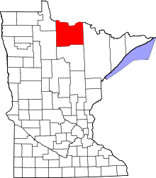 | |
| Unorganized territories | ||
| Unincorporated communities | ||
| Indian reservations | ||
| Ghost towns | ||
| Footnotes | ‡This populated place also has portions in an adjacent county or counties | |