Island View, Minnesota
| Island View, Minnesota | |
|---|---|
| Unincorporated community | |
 Island View, Minnesota Location of the community of Island View within Koochiching County  Island View, Minnesota Island View, Minnesota (the US) | |
| Coordinates: 48°35′43″N 93°10′01″W / 48.59528°N 93.16694°WCoordinates: 48°35′43″N 93°10′01″W / 48.59528°N 93.16694°W | |
| Country | United States |
| State | Minnesota |
| County | Koochiching |
| Elevation | 1,148 ft (350 m) |
| Time zone | UTC-6 (Central (CST)) |
| • Summer (DST) | UTC-5 (CDT) |
| ZIP code | 56649 |
| Area code(s) | 218 |
| GNIS feature ID | 656740[1] |
Island View is an unincorporated community in Koochiching County, Minnesota, United States.
The community is located ten miles east of International Falls at Rainy Lake on State Highway 11 (MN 11).
Island View is located within Rainy Lake Unorganized Territory.
The Rainy Lake Visitor Center at Voyageurs National Park is nearby.
Island View disincorporated in 1992.[2]
| Historical population | |||
|---|---|---|---|
| Census | Pop. | %± | |
| 1950 | 18 | — | |
| 1960 | 13 | −27.8% | |
| 1970 | 44 | 238.5% | |
| 1980 | 101 | 129.5% | |
| 1990 | 150 | 48.5% | |
| U.S. Decennial Census[3] | |||
References
- Rand McNally Road Atlas – 2007 edition – Minnesota entry
- Official State of Minnesota Highway Map – 2011/2012 edition
- Mn/DOT map of Koochiching County – Sheet 4 – 2011 edition
Municipalities and communities of Koochiching County, Minnesota, United States | ||
|---|---|---|
| Cities | 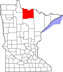 | |
| Unorganized territories | ||
| Unincorporated communities | ||
| Indian reservations | ||
| Ghost towns | ||
| Footnotes | ‡This populated place also has portions in an adjacent county or counties | |
This article is issued from
Wikipedia.
The text is licensed under Creative Commons - Attribution - Sharealike.
Additional terms may apply for the media files.