Wildwood, Minnesota
| Wildwood, Minnesota | |
|---|---|
| Unincorporated community | |
 Wildwood, Minnesota Location of the community of Wildwood within Koochiching County  Wildwood, Minnesota Wildwood, Minnesota (the US) | |
| Coordinates: 47°53′26″N 93°58′01″W / 47.89056°N 93.96694°WCoordinates: 47°53′26″N 93°58′01″W / 47.89056°N 93.96694°W | |
| Country | United States |
| State | Minnesota |
| County | Koochiching |
| Elevation | 1,332 ft (406 m) |
| Time zone | UTC-6 (Central (CST)) |
| • Summer (DST) | UTC-5 (CDT) |
| ZIP code | 56661 |
| Area code(s) | 218 |
| GNIS feature ID | 659009[1] |
Wildwood is an unincorporated community in Koochiching County, Minnesota, United States; located within the Pine Island State Forest.
The community is located between Northome and Effie; near the junction of State Highway 1 (MN 1) and County Road 27. The boundary line between Koochiching and Itasca counties is nearby. Wildwood is located within ZIP code 56661 based in Northome.
Wildwood is located along the boundary line between South Koochiching Unorganized Territory and Northome Unorganized Territory. Caldwell Brook flows through the community.
Nearby places include Northome, Mizpah, Effie, and Bigfork. Wildwood is located 15 miles east of Northome. Wildwood is 18 miles west of Effie; and 74 miles southwest of International Falls.
References
- Official State of Minnesota Highway Map – 2011/2012 edition
- Mn/DOT map of Koochiching County – Sheet 1 – 2011 edition
Municipalities and communities of Koochiching County, Minnesota, United States | ||
|---|---|---|
| Cities | 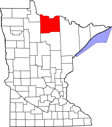 | |
| Unorganized territories | ||
| Unincorporated communities | ||
| Indian reservations | ||
| Ghost towns | ||
| Footnotes | ‡This populated place also has portions in an adjacent county or counties | |
This article is issued from
Wikipedia.
The text is licensed under Creative Commons - Attribution - Sharealike.
Additional terms may apply for the media files.