Lindford, Minnesota
| Lindford, Minnesota | |
|---|---|
| Unincorporated community | |
 Lindford, Minnesota Location of the community of Lindford within Koochiching County  Lindford, Minnesota Lindford, Minnesota (the US) | |
| Coordinates: 48°24′39″N 93°46′55″W / 48.41083°N 93.78194°WCoordinates: 48°24′39″N 93°46′55″W / 48.41083°N 93.78194°W | |
| Country | United States |
| State | Minnesota |
| County | Koochiching |
| Elevation | 1,129 ft (344 m) |
| Time zone | UTC-6 (Central (CST)) |
| • Summer (DST) | UTC-5 (CDT) |
| ZIP code | 56653 |
| Area code(s) | 218 |
| GNIS feature ID | 654798[1] |
Lindford is an unincorporated community in Koochiching County, Minnesota, United States.
The community is located west of Littlefork at the intersection of County Roads 1 and 13.
Lindford is located along the boundary line between Rainy Lake Unorganized Territory and Northwest Koochiching Unorganized Territory.
Nearby places include Littlefork, Loman, and Pelland. Lindford is located 11 miles west of Littlefork; and 13 miles south of Loman.
Lindford is 28 miles southwest of International Falls.
The Big Fork River flows through the community. Lindford is located within ZIP code 56653 based in Littlefork. The community is located on the edge of the Pine Island State Forest.
History
A post office called Lindford was established in 1905, and remained in operation until 1931.[2] The community derives its name from the first postmaster, L. A. Lindwall.[3]
References
- ↑ "Lindford, Minnesota". Geographic Names Information System. United States Geological Survey.
- ↑ "Koochiching County". Jim Forte Postal History. Retrieved 17 July 2015.
- ↑ Warren Upham (1920). Minnesota Geographic Names: Their Origin and Historic Significance. Minnesota Historical Society. p. 284.
- Official State of Minnesota Highway Map – 2011/2012 edition
- Mn/DOT map of Koochiching County – Sheet 3 – 2011 edition
Municipalities and communities of Koochiching County, Minnesota, United States | ||
|---|---|---|
| Cities | 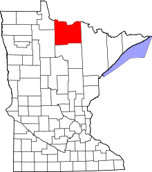 | |
| Unorganized territories | ||
| Unincorporated communities | ||
| Indian reservations | ||
| Ghost towns | ||
| Footnotes | ‡This populated place also has portions in an adjacent county or counties | |