Green Bay (Lake Michigan)
| Green Bay | |
|---|---|
 Green Bay | |
| Location | Brown County, Wisconsin Door County, Wisconsin Kewaunee County, Wisconsin Marinette County, Wisconsin Oconto County, Wisconsin Delta County, Michigan Menominee County, Michigan[1] |
| Coordinates | 45°01′47″N 87°27′39″W / 45.02972°N 87.46083°WCoordinates: 45°01′47″N 87°27′39″W / 45.02972°N 87.46083°W |
| Type | Bay[1] |
| Surface elevation | 581 feet (177 m)[1] |
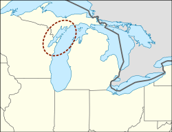
Green Bay is an arm of Lake Michigan, located along the south coast of Michigan's Upper Peninsula and the east coast of Wisconsin. It is separated from the rest of the lake by the Door Peninsula in Wisconsin, the Garden Peninsula in Michigan, and the chain of islands between them, all formed by the Niagara Escarpment. Green Bay is some 120 miles (193 km) long, with a width ranging from about 10 miles (16 km) to 20 mi (32 km). It is 1,626 square miles (4,210 km2) in area.[2][3]
At the southern end of the bay is the city of Green Bay, Wisconsin, where the Fox River enters the bay. The Leo Frigo Memorial Bridge (formerly known as the Tower Drive bridge) spans the point where the bay begins and the Fox River ends, as the river flows south to north into the bay. Locally, the bay is often called the Bay of Green Bay to distinguish the bay from the city. The bay is navigable by large ships.
The bay is located in parts of five counties in Wisconsin (Brown, Door, Kewaunee, Marinette, Oconto), and two in Michigan (Delta, Menominee).
History
Oconto, Green Bay is home to Copper Culture State Park, which has remains dated to around 5000-6000 BC. It is a burial ground of the Copper Culture Indians. This burial ground is considered to be the oldest cemetery in Wisconsin and one of the oldest in the nation. The Ho-Chunk believe that they were created on the shores of Green Bay at a place called Red Banks.[4]
The French Jesuit, Roman Catholic priest, and missionary, Father Claude-Jean Allouez said the first Mass in Oconto on December 3, 1669.[5]
The bay was named la baie des Puants (literally, "the bay of the Stinks") by the French explorer Jean Nicolet as shown on many French maps of the 17th and 18th centuries. According to George R. Stewart, the French received the name from their Indian guides, who called the natives living near Green Bay by a derogatory word meaning "Stinkers", thus the bay was the "Bay of the Stinkers", but this name perplexed the French, and Jacques Marquette thought the name might relate to the smell of the swamps, when he explored the area in May 1673. His fellow explorer Louis Joliet, with two canoes and five voyageurs of French-Indian ancestry (Métis) were on their way to find the Mississippi river. They travelled up the Fox River, nearly to its headwaters. The French also called the bay Baie Verte, and the English kept this name as Green Bay.[6] The name of the bay in the Menominee language is Pūcīhkit, or "bay that smells like something rotting".[7]
See also
- Peshtigo Fire: a firestorm that affected land on both sides of Green Bay, and the deadliest fire in the history of the United States
References
- 1 2 3 U.S. Geological Survey Geographic Names Information System: Green Bay (Lake Michigan)
- ↑ Fox River and Green Bay Statistics Archived 2008-05-09 at the Wayback Machine., Fox River Watch
- ↑ "Green Bay (body of water)". Wisconsinhistory.org. Retrieved 2012-05-22.
- ↑ "Ho-Chunk Oral Tradition - Indian Country Wisconsin". www.mpm.edu. Retrieved 2018-10-05.
- ↑ Hall, George E. 2009. A History of Oconto. 2nd ed., edited by Duane Ebert and Pamela Ann Loberger. Oconto, WI: Oconto County Historical Society, p. 33.
- ↑ Stewart, George R. (1945). Names on the land. Random House. p. 88.
|access-date=requires|url=(help) - ↑ Hoffman, Mike. "Menominee Place Names in Wisconsin". The Menominee Clans Story. Retrieved 2018-10-05.
| Authority control |
|---|