Buldhana district
| Buldhana district | |
|---|---|
| District of Maharashtra | |
 Location of Buldhana district in Maharashtra | |
| Country | India |
| State | Maharashtra |
| Administrative division | Amravati Division |
| Headquarters | Buldhana |
| Tehsils | 1. Buldhana, 2. Chikhli, 3. Deulgaon Raja, 4. Khamgaon, 5. Shegaon, 6. Malkapur, 7. Motala, 8. Nandura, 9. Mehkar, 10. Lonar, 11. Sindkhed Raja, 12. Jalgaon Jamod, 13. Sangrampur |
| Government | |
| • Lok Sabha constituencies | Buldhana, Raver (MH-4)( shared with Jalgaon district)[1] |
| • Assembly seats | Buldhana, Malkapur, Chikhli, Sindkhed Raja, Mehkar, Khamgaon, Jalgaon Jamod |
| Area | |
| • Total | 9,640 km2 (3,720 sq mi) |
| Population (2011) | |
| • Total | 2,586,258 |
| • Density | 270/km2 (690/sq mi) |
| • Urban | 21.2 |
| Demographics | |
| • Literacy | 82.09% |
| • Sex ratio | 928 |
| Major highways |
NH-6 NH-753A |
| Average annual precipitation | 946 mm |
| Website | Official website |
Buldhana district is located in the Amravati division of Maharashtra, India. It is situated at the western border of Vidarbha region and is 500 km away from the state capital, Mumbai. The district has towns and cities like Shegaon, Khamgaon, Lonar, Mehkar, and Dongaon. It is surrounded by Madhya Pradesh in the north, Akola, Washim, and Amravati districts on the east, Jalna district on the south, and Jalgaon and Aurangabad districts on the west.
Buldhana holds religious significance as it is the site of the Shri Gajanan Maharaj temple, Shegaon.[2]
History
Buldhana, along with the rest of Berar Province, was part of the Vidarbha kingdom mentioned in the Mahabharata, a Sanskrit epic poem. Berar formed a part of the Maurya Empire during the reign of Ashoka (272–231 BCE). Berar came under the rule of the Satavahana dynasty (2nd century BCE–2nd century CE), the Vakataka dynasty (3rd to 6th centuries), the Chalukya dynasty (6th to 8th centuries), the Rashtrakuta Dynasty (8th to 10th centuries), the Chalukyas again (10th to 12th centuries), and finally the Yadava dynasty of Devagiri (late 12th to early 14th centuries).
A period of Muslim rule began when Alauddin Khalji, the Sultan of Delhi conquered the region in the early 14th century. The region was part of the Bahmani Sultanate, which broke away from the Delhi Sultanate in the mid-14th century. The Bahmani Sultanate broke up into smaller sultanates at the end of the 15th century. In 1572, Berar became part of the Nizam Shahi sultanate, based at Ahmednagar. The Nizam Shahis ceded Berar to the Mughal Empire in 1595. As Mughal rule started to unravel at the start of the 18th century, Asaf Jah I, the Nizam of Hyderabad, seized the southern provinces of the empire in 1724, forming an independent state. Berar was a part of the independent state.
In 1853, the whole district came under the administration of the British East India Company. Berar was divided into East and West Berar with Buldhana district being included in West Berar. In 1903, Berar was leased by the Nizam of Hyderabad to the British Government of India. Thus, Berar became part of Central Provinces. In 1950, it became part of Madhya Pradesh with Nagpur as its capital. In 1956, along with other Marathi-speaking regions of Vidarbha, it became part of the newly formed state Maharashtra in 1960.
The name of the district is probably derived from Bhil Thana (place of Bhils, a tribal group).[3]
Administration
Sub-Divisions
The district has six revenue sub-divisions headed by a Sub Divisional Officer (SDO): Buldhana, Mehkar, Khamgaon, Malkapur, Jalgaon-Jamod and Sindkhedraja.
Tehsils
As of 2010, the district of Buldhana comprises thirteen talukas (tehsils): Buldhana, Chikhli, Deulgaon Raja, Malkapur, Motala, Nandura, Mehkar, Sindkhed Raja, Lonar, Khamgaon, Shegaon, Jalgaon Jamod, and Sangrampur.[4]
Agriculture
The district superintending agriculture officer comes under the Divisional Joint Director of Amravati Division. There are three sub-divisions at Buldhana, Khamgaon, and Mehkar with a taluka agriculture officer posted at each taluka.
There are multiple circles under each taluka. They are Dhad, Shelapur, Dhamangaon, Motala, Shelsur, Amdapur, Chikhli, Dharangaon, Malkapur, Janephal, Mehkar, Bibi, Lonar, Sakharkherda, Sindkhed Raja, Mera Khurd, Deulgaon Mahi, Deulgaon Raja, Ganeshpur, Pimpalgaon Raja (Khamgaon), Nandura, Shegaon, Jalgaon Jamod, Warwat Khanderao, and Sangrampur.[5]
Police
The district has five police subdivisions and twenty-nine police stations.[6]
Electricity
The distribution of electricity comes under Akola Zone and Buldhana Circle with Buldhana, Khamgaon, and Malkapur Divisions. Each subdivision caters to more nearby talukas and has 33KV distribution substations under them.[7]
Irrigation
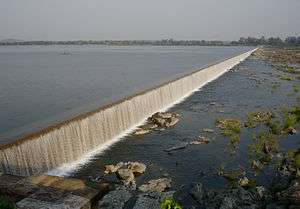
The district comes under Buldhana Irrigation Project Circle along with Akola and Washim district. The circle comes under Vidarbha Irrigation Development Corporation, Nagpur. It has its Major Project division at Shegaon, Kadakpurna at Deulgaon Raja, Mun Project division at Khamgaon, and Minor Irrigation Division at Chikhli and Akola.[8]
The completed irrigation projects are the Nalganga Dam project in Motala and a major project in Vaan having one-fourth of the benefit accrue to Akola district. Many further irrigation projects are under way or are in the planning stages.[9]
Public Works Department
The district comes under Amravati Public Works Region and Akola Public Works Circle. It has one Public Works division at Buldhana with subdivision at Buldhana, Chikhli, Mehkar, and Deulgaon Raja; and a second, Khamgaon division, with subdivisions at Khamgaon, Jalgaon Jamod, and Malkapur; plus the Buldhana District Mechanical Subdivision.
There are Road Project subdivisions at Buldhana and Khamgaon under the Road Project Division of Akola. There is a separate Zilla Parishad Works Division at Buldhana with subdivisions at Buldhana, Kahmgaon, Mehkar, and Malkapur.[10] The department manages Government Rest houses at Buldhana, Khamgaon, Shegaon, Malkapur, Motala, Jalgaon Jamod, Sangrampur, Chikhli, Amdapur, Lavhala (Mehkar), Mehkar, Dongaon, Deulgaon Raja, Deulgaon Mahi, Sindkhed Raja, Lonar, and Nandura.[11]
Politics
The district contributes one seat to the Lok Sabha (Lower House), namely Buldhana (Lok Sabha constituency). Prataprao Ganpatrao Jadhav of Shiv Sena is the current Member of Parliament from Buldhana.
The district has seven seats in the Maharashtra State legislature assembly: Buldhana, Chikhli, Sindkhed Raja, Mehkar, Khamgaon, and Jalgaon Jamod. The seventh seat at Malkapur is part of Raver (Lok Sabha constituency) in Jalgaon district.
Demographics
According to the 2011 census Buldhana district has a population of 2,588,039,[12] roughly equal to the nation of Kuwait[13] or the US state of Nevada.[14] This gives it a ranking of 159th in India (out of a total of 640).[12] The district has a population density of 268 inhabitants per square kilometre (690/sq mi) .[12] Its population growth rate over the decade 2001-2011 was 15.93%.[12] Buldana has a sex ratio of 928 females for every 1000 males,[12] and a literacy rate of 82.09%.[12]
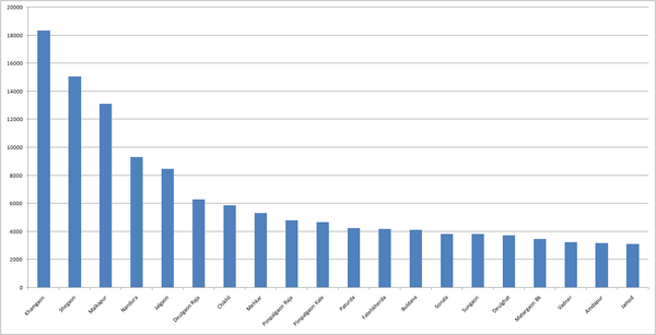
Tehsilwise Religious Population Percentage
| Tehsil Name | Hindu | Buddhist | Muslim | Jain | Christian | Sikh | Other | Atheist |
|---|---|---|---|---|---|---|---|---|
| Buldhana | 68.91 | 13.10 | 16.99 | 0.59 | 0.26 | 0.05 | 0.02 | 0.09 |
| Shegaon | 69.63 | 16.80 | 13.08 | 0.24 | 0.09 | 0.02 | 0.01 | 0.09 |
| Khamgaon | 65.92 | 16.40 | 16.50 | 0.71 | 0.17 | 0.17 | 0.005 | 0.10 |
| Malkapur | 67.85 | 10.60 | 20.14 | 0.98 | 0.12 | 0.03 | 0.01 | 0.30 |
| Nandura | 70.46 | 13.90 | 15.12 | 0.24 | 0.06 | 0.03 | 0.01 | 0.12 |
| Jalgaon Jamod | 75.24 | 10.70 | 13.37 | 0.15 | 0.16 | 0.04 | 0.01 | 0.29 |
| Sangrampur | 75.02 | 12.5 | 11.93 | 0.007 | 0.05 | 0.19 | 0.09 | 0.18 |
| Motala | 73.17 | 13.10 | 13.17 | 0.21 | 0.05 | 0.01 | 0.03 | 0.18 |
| Mehkar | 75.00 | 15.00 | 09.15 | 0.45 | 0.10 | 0.05 | 0.008 | 0.20 |
| Chikhli | 70.82 | 15.00 | 13.53 | 0.37 | 0.15 | 0.01 | 0.01 | 0.10 |
| Deulgaon Raja | 73.33 | 14.70 | 10.54 | 1.04 | 0.19 | 0.06 | 0.007 | 0.16 |
| Sindkhed Raja | 74.65 | 16.80 | 7.94 | 0.22 | 0.12 | 0.04 | 0.02 | 0.22 |
| Lonar | 77.70 | 11.60 | 9.57 | 0.68 | 0.08 | 0.04 | 0.001 | 0.27 |
Languages
Residents of Buldhana communicate in Marathi language. Nihali language, a language isolate of India, is spoken by some 2,000 people (1991) in the Buldana district of Maharashtra. Apart from the commonly used Varhadi, a dialect of Marathi language used in the district includes Andh, an Indo-Aryan language spoken by 100,000 people.[16] Hindi and English are also spoken in the region.
Geography
Rivers
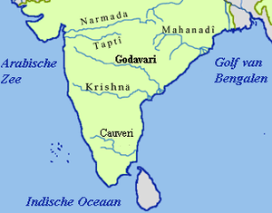
The district lies in the Tapi River and Godavari River basins. Purna River is a tributary of the Tapi River. Nalganga river is a tributary of Purna river. The Penganga and Khadakpurna rivers are tributaries of Godavari River.
Here are the rivers in the district, with their tributaries.
- Purna River
- Vaan River
- Mann River
- Utawali River
- Nipani River
- Mas River
- Bordi River
- Dnyanganga River
- Vishwaganga River
- Nalganga River
- Painganga River
- Khadakpurna River
- Dhamana River
- Koradi River
- Jamvani peth
- Tapi River
Transport
Buses, jeeps, two-wheelers, and railways are the popular modes of transport.
Road
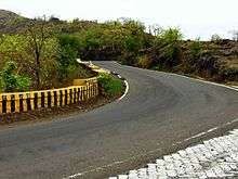
National Highway 6 passes through Khamgaon, Nandura, and Malkapur towns in the district. There are many Maharashtra State Road Transport Corporation bus stands in all towns of the district. There are State Transport bus depots at Buldhana, Malkapur, Chikhli, Mehkar, Khamgaon, Shegaon, and Jalgaon-Jamod.
Vehicles from Nagpur, Amravati, and Akola pass through Khamgaon, Chikhli, Deulgaonraja while going towards Jalna, Aurangabad, and Pune.
Rail
Malkapur, Nandura, and Shegaon railway stations fall under the Bhusawal-Badnera Section of Bhusawal Division of the Central Railway. There is a branch line from Jalamb to Khamgaon. The main line was originally under the Great Indian Peninsula Railway and the branch line between Jalamb and Khamgaon was under the Khamgaon State Railway.
The railway stations in the district, with their codes, are Khamkhed (KMKD), Malkapur (MKU), Wadoda (WDD), Biswa Bridge (BIS), Nandura (NN), Kumgaon Burti (KJL), Jalamb Junction (JM), Khamgaon (KMN), Shegaon (SEG), and Shrikshetra Nagzari (NGZ).
A computerized railway reservation facility is available at Buldhana, Malkapur, and Shegaon, while manual reservation facility is available at city booking office, Khamgaon, Nandura, and Jalamb Junction.
Airport
The nearest airport is at Aurangabad which is 150 km from district headquarters.
Economy
Cotton, sorghum and other cereals, oilseeds, soybean, sunflower, and groundnuts are the predominant crops grown in the district.
Khamgaon and Malkapur are the major cotton trading towns in the district. The district has many minor and medium size irrigation projects. The important ones are Nalganga and Vaan. There are thirteen Agriculture Produce Market Committees-Main Market, one in each tehsil, and there are twenty sub-markets in the districts.[17]
The Indian Council for Agriculture research funded a farm science centre Krishi Vigyan Kendra, Jalgaon Jamod in the district in 1994.[18]
The district has major industrial areas at Khamgoan and Malkapur and has smaller industrial areas at Chikhli, Buldhana, Dasarkhed, Deoulgaonraja, Mehkar, Sangrampur, and Lonar.
Culture
There is a fair called Chaitra Masa Suklapaksha Navami at Shegaon on Rama Navami in Chaitra (March or April) each year.
Common folk arts are Bhajan (devotional singing), Kirtan (devotional chanting with musical instruments), and Gondhal (a complex art form involving ritual acts, dances, songs, and poems).
Youth Hostel Buldhana is one of two youth hostels in Maharashtra and is located near Zilla Krida Sankulan with a 50-bed dormitory and five double rooms.
Places of interest
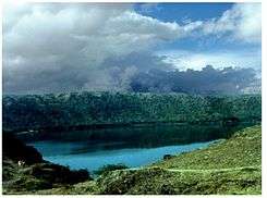
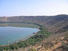
Lonar lake
Lonar crater lake is located in Buldhana district. It is the second largest impact crater in basaltic rock in the world. It was formed 60,000 years ago by a meteor impact. The pH of the water is about 11 (extremely alkaline). Lonar Crater has very different flora and fauna in its vicinity.
Sant Gajanan Maharaj Temple
Gajanan Maharaj from Shegaon, was a saint from India. "Shri Sant Gajanan Maharaj Sansthan", a body of 12 trustees was formed on 12 September 1908 to commemorate the holy place which the saint had hinted about, for Samadhi.[19] Later, a temple was built around his Samadhi/tomb.
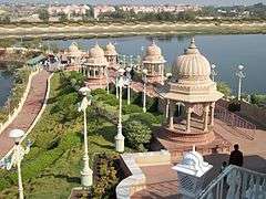
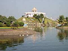
This temple has a tourist attraction called "Anand Sagar", an INR 3 billion project.[20] It is maintained by the Gajanan Maharaj Sansthan. It surrounds a big artificial lake. It has a meditation center, an aquarium, temples, playgrounds, lush green lawns and open theatre where fountain-show is conducted for entertainment. It has been beautifully decorated with state of art artifacts and carvings all over. An amusement park has also started with a toy train encircling the entire place.[21]
Sindkhed Raja
Sindkhed Raja is birthplace of Veer Mata Jijabai, mother of Chhatrapati Shivaji, the town still has the palace and tomb of Lakhuji Jadhav, father of Jijabai.
Other
- Hemadpanthi temples are located at Mehkar-Sonati, Sindhkhed Raja (Nilkantheshwar), and Sakegaon on the Chikhli-Dhad road. Three Shiva temples are located in Dhotra (Nandai), a village on Deulgaon Raja-Chikhli road. Two Shiva temples are located in Kothali (Jaipur) near Motala and also a Hemadpanti temple in Warwand of lord Shiva 10 km far from Buldhana on Khamgaon road.
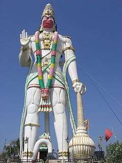
- A 105 feet tall Hanuman idol in Nandura.
- Shri Shiddheshwar Bhagwan Sansthan, Kolara. 10 km from Chikhali on Mehkar Road, Place of Kalbhairav, Rambhau Maharaj Sansthan.
- Temple of Shri Renuka Devi in Chikhli.
- Jagadamba Mata Temple, Buldhana.
- Balaji Temple, Vyankatgiri, Buldhana.
- Budheshwar Temple, Madh, Buldhana (From this place river Painganga originates).
- Balaji Temple in Mehkar.
- Balaji Temple in Deulgaon Raja.
- Panch Pandav temple, Kawhala.
- Shri Pralhad Maharaj Shansthan, Sakharkherda.
- Shri Palsidha Matha, Sakharkherda.
- Shri Bapuji Maharaj, Malegaon Gond.
- Palsi Supo Supoji Maharaj Temple.
- Hanuman Mandir by Samarth Ramdas at Waghali, near Khamgaon.
- Parmanand Sarashwati Maharaj temple at Ran-antari. Tq Chikhali.
- Maruti temple at Ambashi .Tq.Chikhali.
- Jagadamba Mata Temple, Ambashi. Tq.Chikhali.
- Holy Buddha Vihara, Garadgoan.
- The Dnyanganga Sanctuary and Ambabarva Sanctuary are situated in the district.
References
- ↑ (PDF) https://web.archive.org/web/20090306045236/http://164.100.9.199/ecimaps/ecipdf/state_pc_Map/Maharashtra.pdf. Archived from the original (PDF) on 6 March 2009. Retrieved 26 October 2009. Missing or empty
|title=(help) - ↑ "Shree's Samadhi Mandir". Shegaon, Maharashtra, India: Shri Gajanan Maharaj Sansthan. Archived from the original on 10 February 2015.
- ↑ Central Provinces Districts Gazetteers - Buldana District 1910.
- ↑ "बुलढाणा जिल्हा". Buldhana.nic.in. Retrieved 2016-02-27.
- ↑ https://web.archive.org/web/20080224203948/http://agri.mah.nic.in/agri/Asp/CircleOffice.asp. Archived from the original on 24 February 2008. Retrieved 19 March 2008. Missing or empty
|title=(help) - ↑ "Welcome to MPD, INDIA". Mahapolice.gov.in. Retrieved 2016-02-27.
- ↑ "Contact Your Nearest Office". Mahadiscom.in. 2007-10-08. Retrieved 2016-02-27.
- ↑
- ↑ https://web.archive.org/web/20050831051156/http://ceamt.vidcngp.com/cir/Bipc-4.htm. Archived from the original on 31 August 2005. Retrieved 18 March 2008. Missing or empty
|title=(help) - ↑ "Organisation Structure". Mahapwd.com. Retrieved 2016-02-27.
- ↑ "RestHouse". Mahapwd.com. Retrieved 2016-02-27.
- 1 2 3 4 5 6 "District Census 2011". Census2011.co.in. 2011. Retrieved 2011-09-30.
- ↑ US Directorate of Intelligence. "Country Comparison:Population". Retrieved 2011-10-01.
Kuwait 2,595,62
- ↑ "2010 Resident Population Data". U. S. Census Bureau. Archived from the original on 2011-01-01. Retrieved 2011-09-30.
Nevada, 2,700,551
- 1 2 "Population by religion community - 2011". Census of India, 2011. The Registrar General & Census Commissioner, India. Archived from the original on 25 August 2015.
- ↑ M. Paul Lewis, ed. (2010). "Andh: A language of India". Ethnologue: Languages of the World (16th ed.). Dallas, Texas: SIL International. Retrieved 2011-09-28.
- ↑ https://web.archive.org/web/20071105140245/http://www.msamb.com/english/apmc/apmcs/buldhana.htm. Archived from the original on 5 November 2007. Retrieved 1 February 2007. Missing or empty
|title=(help) - ↑ https://web.archive.org/web/20100412133701/http://dare.nic.in/KVKList.htm. Archived from the original on 12 April 2010. Retrieved 24 November 2009. Missing or empty
|title=(help) - ↑ "About Gajanan Maharaj Sansthan".
- ↑ https://www.maharashtratourism.gov.in/treasures/temple/sant-gajanan-maharaj-shegoan
- ↑ http://www.gajananmaharaj.org/anandsagarenglish
External links
| Wikisource has the text of the 1911 Encyclopædia Britannica article Buldana. |
- Buldhana district website
- Buldhana district map
- Lonar crater
- Anuradha College of Engineering
- Jawahar Navodaya Vidyalaya, Shegaon
- Krishi Vigyan Kendra, Jalgaon Jamod
- Vivekanand Ashram, Hiwara Ashram, Tq. Mehkar
Buldhana district topics | ||
|---|---|---|
| Subdivisions and tehsils | | |
| Cities, towns and villages |
| |
| Railway stations | ||
| Roads | ||
| Historical places | ||
| Geography | ||
| Lok Sabha constituencies | ||
| Vidhan Sabha constituencies |
| |
| Religious | ||
| People |
| |
| See Also |
| |
| Topics | |||||||||||||
|---|---|---|---|---|---|---|---|---|---|---|---|---|---|
| Regions | |||||||||||||
| Divisions and Districts |
| ||||||||||||
| Million-plus cities in Maharashtra | |||||||||||||
| Other cities with municipal corporations | |||||||||||||
Portal: Maharashtra | |||||||||||||
Coordinates: 20°31′58″N 76°10′58″E / 20.53278°N 76.18278°E