Malkapur, Buldhana district
| Malkapur | |
|---|---|
| City | |
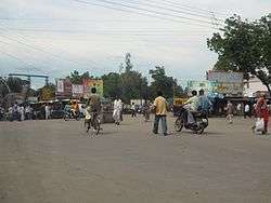 Tehsil chowk or Karanja chowk in Malkapur. | |
| Nickname(s): Vidarbhache Praveshdwar | |
 Malkapur | |
| Coordinates: 20°53′06″N 76°12′00″E / 20.885°N 76.2°ECoordinates: 20°53′06″N 76°12′00″E / 20.885°N 76.2°E | |
| Country |
|
| State | Maharashtra |
| District | Buldhana |
| Elevation | 255 m (837 ft) |
| Population (2011)[1] | |
| • Total | 178,534 |
| • Density | 230/km2 (600/sq mi) |
| Language | |
| • Official | Marathi |
| Time zone | UTC+5:30 (IST) |
| PIN | 443101 |
| Telephone code | 07267 |
| Vehicle registration | MH 28 |
| Sex ratio | 0.941 ♂/♀ |
| Literacy | 75.91% |
Malkapur is the biggest city and a municipal council in the Buldhana district of Maharashtra, India. It is a major industrial and educational center in Buldhana district.
History
Prince Mohammad Malik Khan founded the town of Malkapur around the 13th century, and named it after his daughter, Princess Malika. The town gained its independence from the Bahamani Sultanate in 1399.[2] Malkapur is mentioned in Ain-i-Akbari as the headquarters of a paragana in the sarkar of Narnala. However, the story is improbable as no known record exists of any journey in this direction by Miran Ghani Adil Khan, a Faruqi prince of the period.
In 1761, the town was rich enough to pay Rs. 60,000 to the army of Raghunathrao, who later became a ruling Peshwa from 1773-1774, for exemption from plunder. The Nizams used to keep a force of about 20,000 men in this frontier district of their dominions. Daulatrav Shinde and Raghuji Bhosle were encamped near Malkapur when the British envoy Colonel Collins, after presenting General Lord Wellesley's ultimatum, quit Shinde's camp in 1803.
According to the Sarvajanik Granthalay (Public Library) of Malkapur, the great freedom fighter of India, Netaji Subhash Chandra Bose, made his last speech at a public meeting arranged in front of this library in the early 1940s. Bose was arrested and imprisoned in his house after this event.
Demographics
According to the 2001 population census,[3][4] Malkapur has a population of 72,015. Males constitute 51% of the population and females 49%. Malkapur has an average literacy rate of 76%, higher than the national average of 59.5%. The male literacy is 75% and female literacy is 63%. In Malkapur, 15% of the population is under 6 years of age.
Economy
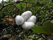
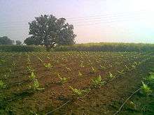
Malkapur is one of the largest cotton producers in the area. In the British era, it was known as the "White gold of Vidarbha". Malkapur has a vast paper industry and the primary paper suppliers to Mumbai are in Malkapur. Malkapur has many Dal mills, and a major agricultural industry specializing in Mahyco and Ankur seeds, chemical plants, and a fruit ripening chamber. Malkapur is a well-known grain and cloth market due to its proximity to Madhya Pradesh. It is one of the major producer of red chillies.
Transport
Malkapur is located on the Hajira - Kolkata National Highway 6, which is a part of the Asian Highway 46 from Kharagpur to Dhule.Malkapur railway station lies on the Howrah-Nagpur-Mumbai line.[5] Malkapur bus station is on Buldhana road. A boat facility is also available at Nalganga river.
Politics
- Member Loksabha (Raver Region) : Raksha Khadse (Bhartiya Janta Party)
- Member Vidhansabha (Malkapur and Nandura Region) : Shri. Chensukh Sancheti (Bhartiya Janta Party)
Health
The Chalis Bigha area of Malkapur has a couple of health facilities such as the 50-bedded sub-district hospital with OPD and in-patient services.
Tehsils
The tehsil consists of 64 villages, as enumerated below:
- Dudhalgaon Kh.
- Waghola
- Chinchol
- Hingana Nagapur
- Narvel
- Mhaiswadi
- Chikhali
- Rantham
- Bhangura
- Tighra Pr. Malkapur
- Rangaon
- Wiwara
- Dasarkhed
- Talaswada
- Tandulwadi Pr. Malkapur
- Telkhed
- Zodga
- Harsoda
- Shivni
- Nimboli
- Dharangaon
- Anurabad
- Wadoda
- Panhera Pr. Malkapur
- Kund Bk.
- Kund Kh.
- Malkapur
- Khokodi
- Nimbari
- Wakodi
- Gadegaon
- Khaparkhed
- Bahapura
- Gorad
- Deodhaba
- Bhalegaon
- Hingana Kazi
- Khadki
- Pimpalkhunta (Mahadeo)
- Khamkhed Pr. Malkapur
- Wajirabad
- Jambhuldhaba
- Gaulkhed
- Chinchkhed Bk.
- Harankhed
- Wadji
- Aland
- Dudhalgaon Bk.
- Lonwadi Phakir. Malkapur
- Balad Pr. Malkapur
- Waghud
- Ghirni
- Makner
- Datala
- Siradhon
- Morkhed Kh.
- Morkhed Bk.
- Umali
- Bhadgani
- Nimkhed Pr. Vadner
- Pimpalkhuta Pr. Vadner
- Lasura
- Warkhed
- Sawali
References
- ↑ (PDF) https://mahades.maharashtra.gov.in/files/report/pca_2011.pdf. Missing or empty
|title=(help) - ↑ "Malkapur, India - Discover World". www.discoverworld.com. Retrieved 2018-03-26.
- ↑ "Census of India 2001: Data from the 2001 Census, including cities, villages and towns (Provisional)". Census Commission of India. Archived from the original on 2004-06-16. Retrieved 2008-11-01.
- ↑ Census Dashboard http://censusindia.gov.in/2011census/censusinfodashboard/index.html
- ↑ Running, Train. "MKU/Malkapur railway station". train running status. Train running status. Retrieved 22 June 2017.
Places adjacent to Malkapur, Buldhana district | ||||||||||
|---|---|---|---|---|---|---|---|---|---|---|
| ||||||||||
Buldhana district topics | ||
|---|---|---|
| Subdivisions and tehsils |  | |
| Cities, towns and villages |
| |
| Railway stations | ||
| Roads | ||
| Historical places | ||
| Geography | ||
| Lok Sabha constituencies | ||
| Vidhan Sabha constituencies |
| |
| Religious | ||
| People |
| |
| See Also |
| |
| Topics | |||||||||||||
|---|---|---|---|---|---|---|---|---|---|---|---|---|---|
| Regions | |||||||||||||
| Divisions and Districts |
| ||||||||||||
| Million-plus cities in Maharashtra | |||||||||||||
| Other cities with municipal corporations | |||||||||||||
Portal: Maharashtra | |||||||||||||