Konkan division
| Konkan division | |
|---|---|
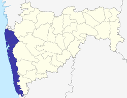 Location of Konkan division in Maharashtra | |
| Coordinates: 18°57′53″N 72°49′33″E / 18.96472°N 72.82583°ECoordinates: 18°57′53″N 72°49′33″E / 18.96472°N 72.82583°E | |
| Country |
|
| State | Maharashtra |
| Districts | 1. Thane, 2. Mumbai city, 3. Mumbai suburban, 4. Ratnagiri, 5. Sindhudurg, 6. Raigad, 7. Palghar |
| Area | |
| • Total | 30,746 km2 (11,871 sq mi) |
| • Under irrigation | 4,384.54 km2 (1,692.88 sq mi) |
| Population (2011 census) | |
| • Total | 28,739,397 |
| Literacy | 98.88% |
Konkan division is one of the six administrative divisions of Maharashtra state in India. It comprises the Konkan region, which occupies the entire west coast of Maharashtra. The two districts in the state capital Mumbai also fall in Konkan division.
History of administrative districts in Konkan Division
There have been changes in the names of Districts and has seen also the addition of newer districts after India gained Independence in 1947 and also after the state of Maharashtra was formed.
- Since 1947, east-west tracts of Thane district on Salsette Island, starting with the City of Bandra, then Andheri, then finally Borivali to Dahisar were carved out and added to the former Bombay, now 'Mumbai,' district. Recently, the 'Mumbai' district was bifurcated into the Mumbai & Mumbai Suburban districts; the latter covers Salsette Island.
- In 1961 the Konkan region became a part of the newly formed state of Maharashtra. Prior to this it was a part of Bombay province which was split to form Gujarat and Maharashtra.
- Creation of the Sindhudurg from the southern areas of the Ratnagiri district.
- The erstwhile Kolaba district was renamed as Raigad.
- In 2014, Palghar district was carved out of Thane district with the inclusion of the northern parts of Thane district which include Palghar, Vada, Vikramgad, Jawhar, Mokhada, Dahanu and Talasari Vasai talukas in the new district.[1]
Pending demand for bifurcation or trifurcation of Thane District
The Census of India 2011 revealed that Thane district has emerged as the most populous district in Maharashtra where population of Thane district has even surpassed Mumbai Suburban district, and Government of Maharashtra and several political parties and organisations have come up with various proposals to bifurcrate or even trifurcate Thane district on Tribal, Urban and Rural areas, some of them include.
- Bifurcate Thane district into two districts with new Palghar tribal district:
Bifurcation of Thane district is an old demand where it is proposed Thane district be split into two districts where the northern and eastern talukas are included into the proposed Palghar Tribal District.
- Trifurcate Thane district into urban, rural, and tribal districts:
Thane Urban district: This demand comes from the unique fact where Thane district has 7 contiguous and adjoining connected Municipal Corporations. Hence it is feasible to have an urban district of only 7 Municipal Corporations and two Municipal Councils namely Vasai-Virar Municipal Corporation, Mira-Bhayander Municipal Corporation, Bhivandi-Nizampur Municipal Corporation, Thane Municipal Corporation, Kalyan-Dombivali Municipal Corporation, Navi Mumbai Municipal Corporation, Ulhasnagar Municipal Corporation and the Municipal councils of Badlapur-Kulgaon, Ambernath and the Cidco administered areas. The Panvel, New Panvel, and the Navi Mumbai International Airport regions also can be included in this proposed entirely urban district. Current proposal is to have Thane city, Navi Mumbai and Mira Bhayander into Thane urban district.
Thane Rural District: The second district is the area which is south of the Tansa River and the rural areas not included in the Urban and Tribal districts which includes talukas of Vasai, Bhivandi, Shahapur, Kalyan, Murbad and Ambernath. Also its proposed to get the four major urban areas and towns of Karjat, Khopoli, Panvel and Uran-JNPT currently in Raigadh district, by merging the three talukas of Raigadh district currently bordering Thane district and also which are on the Mumbai Pune Highway and Mumbai Pune Railway lines, namely the Talukas of Panvel, Karjat and Uran. For historical facts both Panvel and Karjat talukas were part of Thane district and in 1891 they were merged with Kolaba or the currently called Raigad district.
Palghar district (Tribal): The third district can be carved of all areas and talukas north of Tansa river, which would be the tribal regions which includes talukas of Jawhar, Talasari, Dahanu, Mokhada, Vikramgad, Vada, and Palghar. This district can be a hundred percent tribal district.
Hence this proposal is centered on a third district comprising the non-tribal rural areas and talukas of Thane district and three talukas of Raigadh district.
All these proposals are currently actively under consideration.
See also
References
- ↑ "Palghar becomes Maharashtra's 36th district". Mid Day. 1 August 2014. Retrieved 8 September 2014.
| Topics | |||||||||||||
|---|---|---|---|---|---|---|---|---|---|---|---|---|---|
| Regions | |||||||||||||
| Divisions and Districts |
| ||||||||||||
| Million-plus cities in Maharashtra | |||||||||||||
| Other cities with municipal corporations | |||||||||||||
Portal: Maharashtra | |||||||||||||