Araria district
| Araria district | |
|---|---|
| District of Bihar | |
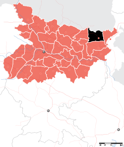 Location of Araria district in Bihar | |
| Country | India |
| State | Bihar |
| Administrative division | Purnia |
| Headquarters | Araria |
| Government | |
| • Lok Sabha constituencies | Araria |
| • Assembly seats | Narpatganj, Raniganj, Forbesganj, Araria, Jokihat, Sikti |
| Area | |
| • Total | 2,830 km2 (1,090 sq mi) |
| Population (2011) | |
| • Total | 2,806,200 |
| • Density | 990/km2 (2,600/sq mi) |
| Demographics | |
| • Literacy | 90 per cent |
| • Sex ratio | 100 |
| Major highways | NH 57 |
| Website | Official website |
Araria district is one of the thirty-eight districts of Bihar state, India, and Araria town is the administrative headquarters of this district. Araria district is a part of Purnia division. The district occupies an area of 2830 km². It has a view of Mount Kangchenjunga (One of the great peaks of the Himalayan range). This District has total 9 blocks (CD Block ).
Origin of name
During the British period, the area where Mr. Forbes's bungalow was located was called "Residential Area", which people abbreviated to R. Area. Over time, R. Area acquired the pronunciation Arariya.
History
Araria district,which was previously part of Purnia district, is part of the Mithila region.[1] Mithila first gained prominence after being settled by Indo-Aryan peoples who established the Mithila Kingdom (also called Kingdom of the Videhas).[2] During the late Vedic period (c. 1100–500 BCE), Kingdom of the Videhas became one of the major political and cultural centers of South Asia, along with Kuru and Pañcāla. The kings of the Kingdom of the Videhas were called Janakas.[3] The Mithila Kingdom was later incorporated into the Vajji confederacy, which had its capital in the city of Vaishali, which is also in Mithila.[4] The territory of the present-day district became Araria sub-division of the erstwhile Purnia district in 1964. Araria district was formed in January 1990 as one of the administrative districts of under Purnia Division.
Geography
Araria district occupies an area of 2,830 square kilometres (1,090 sq mi),[5] comparatively equivalent to Russia's Zemlya Georga.[6] The major rivers of this district are Kosi,parman Suwara, Kali and Koli.
Economy
In 2006 the Indian government named Araria one of the country's 250 most backward districts (out of a total of 640).[7] It is one of the 36 districts in Bihar currently receiving funds from the Backward Regions Grant Fund Programme (BRGF).[7]
Agriculture
Main agricultural produces of this district are paddy, maize and jute.
Sub-Divisions
Araria district comprises the following Sub-Divisions:
- Araria
- Forbesganj
Araria sub-division comprises 4 blocks: Araria, Bhargama, Siktti and Raniganj. Frobesganj sub-division comprises 5 blocks: kursakanta, Forbesganj, Bhargama, raniganj and Narpatganj. raniganj and bhargama are under the joint jurisdiction of both the sub-divisions. There are six Vidhan Sabha constituencies in this district: Narpatganj, Raniganj, Forbesganj, Araria, Jokihat and Sikti. All of these are part of Araria Lok Sabha constituency.
Demographics
According to the 2011 census Araria district has a population of 2,806,200,[8] roughly equal to the nation of Jamaica[9] or the US state of Utah.[10] This gives it a ranking of 139th in India (out of a total of 640).[8] The district has a population density of 992 inhabitants per square kilometre (2,570/sq mi) .[8] Its population growth rate over the decade 2001-2011 was 30%.[8] Araria has a sex ratio of 921 females for every 1000 males,[8] and a literacy rate of 55.1%.[8] The population of Araria district has a large concentration of Muslims.[8]
2017 North Bihar Floods
2017 Floods affected 19 districts of North Bihar causing death of 514 people,[11][12][13][14] in which Araria district accounted for 95 deaths alone.[15][16] Floods have claimed 215 lives in Araria over 18 years, of which 61 in 2016. [17]
Notable people
- 1st DM, Ashok Kumar Chauhan
- Current DM, Himanshu Sharma
- Current SP, Dhurat Sayli Savlaram
- Current SDM, Forbesganj, Anil Kumar
- Current SDM, Araria, Sanjay Kumar, BAS
- Phanishwar Nath 'Renu', novelist and story writer.
- Subrata Roy, The chairman of Sahara Group, was born in the Ashram muhhalla of the town.
- Parmanand Rishideo, Indian Politician and is the first and only person from the Musahar community to have studied M.A French Literature from Jawaharlal Nehru University, New Delhi.
See also
References
- ↑ https://books.google.co.in/books?id=A0i94Z5C8HMC&lpg=PA30&pg=PA27&redir_esc=y#v=onepage&q&f=false
- ↑ Michael Witzel (1989), Tracing the Vedic dialects in Dialectes dans les litteratures Indo-Aryennes ed. Caillat, Paris, pages 13, 17 116–124, 141–143
- ↑ Witzel, M. (1989). "Tracing the Vedic dialects". In Caillat, C. Dialectes dans les litteratures Indo-Aryennes. Paris: Fondation Hugot. pp. 141–143.
- ↑ Hemchandra, R. (1972). Political History of Ancient India. Calcutta: University of Calcutta.
- ↑ Srivastava, Dayawanti et al. (ed.) (2010). "States and Union Territories: Bihar: Government". India 2010: A Reference Annual (54th ed.). New Delhi, India: Additional Director General, Publications Division, Ministry of Information and Broadcasting (India), Government of India. pp. 1118–1119. ISBN 978-81-230-1617-7.
- ↑ "Island Directory Tables: Islands by Land Area". United Nations Environment Program. 1998-02-18. Retrieved 2011-10-11.
Zemlya Georga 2,821km2
- 1 2 Ministry of Panchayati Raj (September 8, 2009). "A Note on the Backward Regions Grant Fund Programme" (PDF). National Institute of Rural Development. Archived from the original (PDF) on April 5, 2012. Retrieved September 27, 2011.
- 1 2 3 4 5 6 7 "District Census 2011". Census2011.co.in. 2011. Retrieved 2011-09-30.
- ↑ US Directorate of Intelligence. "Country Comparison:Population". Retrieved 2011-10-01.
Jamaica 2,868,380 July 2011 est
- ↑ "2010 Resident Population Data". U. S. Census Bureau. Archived from the original on 2013-10-19. Retrieved 2011-09-30.
Utah 2,763,885
- ↑ "Floods in state not man-made, says minister".
- ↑ "Flood Situation Improves In Bihar, Number Of Dead At 514".
- ↑ "Flood situation worsens in Bihar, death toll rises to 253".
- ↑ "Bihar floods: 119 dead; bridge collapse caught on camera".
- ↑ "बिहार : बाढ़ ने लिखी खौफनाक कहानी, अबतक 379 व्यक्तियों की मौत और 1.61 करोड आबादी प्रभावित".
- ↑ "Death toll in Bihar floods mounts to 304; situation grim in UP".
- ↑ "Changing patterns of Bihar floods a cause for concern for state authorities".
External links
| Wikivoyage has a travel guide for Araria District. |
Places adjacent to Araria district | |
|---|---|
One of the tallented politicians let shri md. Taslim uddin sb. Is the muslim mp in the first mp in araria district
| State symbols | |
|---|---|
| History |
|
| Administration | |
| Overviews | |
| Divisions and districts | |
| Cities | |
| Municipal Corporation |
|
| Poltics | |
| Culture | |
Coordinates: 26°07′48″N 87°28′12″E / 26.13000°N 87.47000°E