Hingoli district
| Hingoli district | |
|---|---|
| District of Maharashtra | |
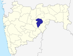 Location of Hingoli district in Maharashtra | |
| Country | India |
| State | Maharashtra |
| Administrative division | Aurangabad division,Marathwada |
| Headquarters | Hingoli |
| Tehsils | Hingoli, Kalamnuri, Sengaon, Aundha Nagnath, Basmath |
| Government | |
| • Lok Sabha constituencies | Hingoli |
| • Assembly seats | 3 |
| Area | |
| • Total | 4,526 km2 (1,747 sq mi) |
| Population (2011) | |
| • Total | 1,177,345[1] |
| • Urban | 15.60 |
| Website | Official website |
Hingoli district is an administrative district in the state of Maharashtra in India. The district headquarters are located at Hingoli. The district occupies an area of 4,526 km² and has a population of 11,77,345 of which 15.60% were urban (as of 2011).[2] Hingoli was actually known as the Nizams military base as it was bordered with Vidharbha. In that era military troops, hospitals, veterinary hospital were in operation from Hingoli. Being a military base the city was one of the important and famous places of the Hyderabad state.One of the twelve Jyotirlinga shrines, the Aundha Nagnath is located in Hingoli district.
As of 2011 it is the third least populous district of Maharashtra (out of 36), after Sindhudurg and Gadchiroli.[1]
History

The territory of the present district became part of Bombay state in 1956 and Maharashtra state in 1960 as part of Parbhani district. This district was carved out from Parbhani district on 1 May 1999 with five own tehsils: Hingoli, Kalamanuri, Sengaon, Aundha Naganath, and Basamat.
Geography
Hingoli is situated at the northern part of Marathwada in Maharashtra. Borders of Hingoli are surrounded by districts Washim and Yavatmal in northern side, Parbhani in western side, and Nanded at south-eastern side.
Demographics
According to the 2011 census Hingoli district has a population of 1,177,345;[1] roughly equal to the nation of Timor-Leste[3] or the US state of Rhode Island.[4] This gives it a ranking of 401st in India (out of a total of 640).[1] The district has a population density of 244 inhabitants per square kilometre (630/sq mi) .[1] Its population growth rate over the decade 2001-2011 was 19.43%.[1] Hingoli has a sex ratio of 942 females for every 1000 males,[1] and a literacy rate of 78.17%.[1] Marathi is the major language spoken and also the official language. Nearly 83% of the population speaks Marathi as the mother tongue. Native speakers of Deccani Urdu, Hindi and Banjari/Labhani languages are also present in significant numbers.[5]
Governance
This district is divided into two sub-divisions, which are further divided into five talukas. Hingoli sub-division is divided into three talukas: Hingoli, Kalamnuri and Sengaon. Basmath sub-division is divided into two talukas: Aundha and Basmath.
There are three Vidhan Sabha constituencies in this district: Basmath, Kalamnuri and Hingoli. All three are part of Hingoli Lok Sabha constituency.[6]
Economy
In 2006 the Ministry of Panchayati Raj named Hingoli one of the country's 250 most backward districts (out of a total of 640).[7] It is one of the twelve districts in Maharashtra currently receiving funds from the Backward Regions Grant Fund Programme (BRGF).[7]
Places of interest
Hindu temples and shrines
Some of the notable Hindu temples are as follows:[8][9]
- Mallinath Digambar Jain Temple, Shirad Shahpur,
- Aundha Nagnath is one of the twelve jyotirlingas from Hindu mythology. It is situated in the town of same name, Aundha, in Hingoli district.
- Tulja Devi Sansthan Ghota, Tehsil - Hingoli.
- Sant Namdev Sansthan Narsi, Giroli.
- Tulja Bhavani Devi Temple, or Tulaja Devi Sansthan, Kalamnuri.
- Jaleshwar Mahadev Temple (present in the lake), Hingoli.
- Shri Datta Mandir, Mangalwara, Hingoli.
- Dakshinmukhi Hanuman temple, Khatkali
- Barashiv Hanuman Mandir, Karanjala
- Kanifnath temple,khairi ghumat,sengaon
- Jagdamba devi temple,avi's house bhandari,sengaon
See also
Notes
- 1 2 3 4 5 6 7 8 "District Census 2011". Census2011.co.in. 2011. Retrieved 2011-09-30.
- ↑ "Archived copy". Archived from the original on 11 January 2010. Retrieved 27 August 2009.
- ↑ US Directorate of Intelligence. "Country Comparison:Population". Retrieved 2011-10-01.
Timor-Leste 1,177,345 July 2011 est.
- ↑ "2010 Resident Population Data". U. S. Census Bureau. Archived from the original on 1 January 2011. Retrieved 2011-09-30.
Rhode Island 1,052,567
- ↑ "2011 Language Census Data".
- ↑ "Districtwise List of Assembly and Parliamentary Constituencies". Chief Electoral Officer, Maharashtra website. Archived from the original on 18 March 2010. Retrieved 2009-03-24.
- 1 2 Ministry of Panchayati Raj (8 September 2009). "A Note on the Backward Regions Grant Fund Programme" (PDF). National Institute of Rural Development. Archived from the original (PDF) on 5 April 2012. Retrieved 27 September 2011.
- ↑ http://hingoli.nic.in/Ntouristplace.html
- ↑ https://www.maharashtratourism.gov.in/docs/default-source/district-draft-toursim-plans/hingoli-district.pdf?sfvrsn=2
External links
Places adjacent to Hingoli district | ||||||||||
|---|---|---|---|---|---|---|---|---|---|---|
| ||||||||||
| Topics | |||||||||||||
|---|---|---|---|---|---|---|---|---|---|---|---|---|---|
| Regions | |||||||||||||
| Divisions and Districts |
| ||||||||||||
| Million-plus cities in Maharashtra | |||||||||||||
| Other cities with municipal corporations | |||||||||||||
Portal: Maharashtra | |||||||||||||