Thane
| Thane | |
|---|---|
| City | |
| Nickname(s): Thane,Thana | |
 Thane  Thane | |
| Coordinates: 19°10′21″N 72°57′25″E / 19.172431°N 72.957019°ECoordinates: 19°10′21″N 72°57′25″E / 19.172431°N 72.957019°E | |
| Country |
|
| State | Maharashtra |
| District | Thane |
| Government | |
| • Type | Municipality |
| • Body | Council of Thane |
| • Mayor | Minakshi Shinde |
| • Deputy Mayor | Rajendra Sapte |
| • Municipal Commissioner | Sanjeev Jaiswal |
| Area | |
| • Total | 147 km2 (57 sq mi) |
| Population (2011) | |
| • Total | 1,886,941 |
| • Density | 13,000/km2 (33,000/sq mi) |
| Demonym(s) | Thanekar |
| Language | |
| • Official | Marathi |
| Time zone | UTC+5:30 (IST) |
| PIN |
400 601 400 602 400 603 400 604 400 605 400 606 400 607 400 615 |
| Telephone code | 022 |
| Vehicle registration | MH-04 |
| Lok Sabha constituencies |
Thane Kalyan |
| Vidhan Sabha constituencies |
Thane Kopri-Pachpakhadi Ovala-Majiwada Mumbra-Kalwa |
| Website |
www |
Thane, colloquially called Thana, is a metropolitan city in India. Thane city coincides entirely with Thane taluka, one of the seven talukas of Thane district; also, it is the headquarter of the namesake district. With a population of 1,841,488 distributed over a land area of about 147 square kilometres (57 sq mi), Thane city is the 16th most populated city in India with a population of 18.9 Lakhs according to the 2011 census. This city is also called as "City of Lakes" as the city is surrounded by 9 lakes.
Located on the northwestern side of the state of Maharashtra, the city is an immediate neighbour of Mumbai city and a part of the Mumbai Metropolitan Region, one of the most populous urban agglomerations in the world.
Etymology and other names
The word 'Thane' is derived from Sanskrit word 'sthāna' (Sanskrit: स्थान) which means 'place'. The name Thane, locally pronounced [ˈʈʰaːɳeː], has been variously romanised as Tana,[1] Thana,[2] Thâṇâ,[3] and Thane.[4] Ibn Battuta and Abulfeda knew it as Kukin Tana; Duarte Barbosa as Tana Mayambu.[5]
History
A copper plate dating to AD 1078 was discovered near the foundations of Thane Fort in 1787. A land grant from Arikesara Devaraja, lord of Tagara, he addresses the inhabitants of a city called "Sri Sthanaka".[6]
The British occupied Salsette Island, Thana Fort, Fort Versova, and the island fort of Karanja in 1774.[7]
Transport
Railways
Thane was the terminus for the first ever passenger train in Asia. On 16 April 1853, the passenger train service was inaugurated between Colaba and Thane.[8] Covering a distance of 34 km (21 mi), it was hauled by three locomotives: Sahib, Sindh and Sultan.
Thane is connected with neighbouring suburbs through Central and Trans-Harbour Line Suburban railway network. Thane is a railway junction for the Thane-Vashi Harbour Line and Central Line. It has become the busiest station in Mumbai and one of the busiest in India and handles 654,000 passengers daily.[9]
As of 2013, there are plans of extending the Ghatkopar-Mulund Metro line up to Thane.[10]
On 26 August 2015, MMRDA sanctions ₹354 billion for 118 km Mumbai metro network. This includes a 40-km Wadala-Ghatkopar-Thane-Kasarvadavali Metro-4 corridor via Wadala GPO and R.A.Kidwai Marg costing ₹120 billion.[11]

Geography
Climate
Thane has a tropical monsoon climate that borders on a tropical wet and dry climate. The overall climate is equable with high rainfall days and very few days of extreme temperatures.
In Thane, temperature varies from 22 °C to 36 °C. Winter temperatures can fall to 12 °C at night while summer temperatures can rise to over 40 °C at noon. The lowest daytime temperatures are witnessed during the peak of the summer monsoon in July and August when temperatures can drop to about 25 °C. Out of total rainfall, 80% rainfall is experienced during June to October. Average annual rainfall is 2000–2500 mm and humidity is 61-86%, making it a humid-perhumid zone.
| Climate data for Thane | |||||||||||||
|---|---|---|---|---|---|---|---|---|---|---|---|---|---|
| Month | Jan | Feb | Mar | Apr | May | Jun | Jul | Aug | Sep | Oct | Nov | Dec | Year |
| Average high °C (°F) | 29.5 (85.1) |
31.3 (88.3) |
32.7 (90.9) |
33.1 (91.6) |
33.3 (91.9) |
31.9 (89.4) |
29.8 (85.6) |
29.3 (84.7) |
30.1 (86.2) |
32.9 (91.2) |
33.4 (92.1) |
31.0 (87.8) |
31.7 (89.1) |
| Average low °C (°F) | 15.4 (59.7) |
17.3 (63.1) |
20.6 (69.1) |
23.7 (74.7) |
26.1 (79) |
25.8 (78.4) |
24.8 (76.6) |
24.5 (76.1) |
24.0 (75.2) |
23.1 (73.6) |
20.5 (68.9) |
18.2 (64.8) |
22.1 (71.8) |
| Average precipitation mm (inches) | 3.1 (0.122) |
1.0 (0.039) |
1.5 (0.059) |
2.3 (0.091) |
25.1 (0.988) |
541.3 (21.311) |
922.0 (36.299) |
539.7 (21.248) |
326.9 (12.87) |
93.2 (3.669) |
19.1 (0.752) |
2.3 (0.091) |
2,477.5 (97.539) |
| Source: Government of Maharashtra | |||||||||||||

Demographics
The population of Thane according to the 2011 census is 1,886,941.[12] The average literacy rate of Thane city is 91.36 percent of which male and female literacy was 94.19 and 88.14 percent. The sex ratio of Thane city is 882 females per 1000 males. Child sex ratio of girls is 900 per 1000 boys. Total children (0-6) in Thane city are 186,259 as per Census India report on 2011. There were 98,017 boys while 88,242 are girls. Children form 10.24% of total population of Thane City.[13]
The dominant language spoken in Thane is Marathi. Some of the East Indian families in the Khatri ward of Thane still speak Portuguese.[14] During period of 1800, Thane had the largest number of Jews in Indian subcontinent.[15]
Tourism
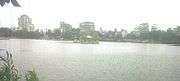
Thane's lakes include Masunda Lake, also known as Talao Pali,[16] Kachrali Lake, and Upvan Lake. The Kopineshwar Temple on the banks is the oldest temple in the entire district of Thane. It was built and renovated in about 1750 by Chimajji Appa.[16]
Lakes in Thane
| No. | Lake Name | Location | Area |
|---|---|---|---|
| 1 | Brahamala Lake | Near Babubhai Petrol Pump in Uthalsar Ward Committee | Area of lake is 0.5173 hectare (garden area: 0.4 hectare) |
| 2 | Datiwali Lake | East side of Diva station situated in the marshland of Ulhas river in Mumbra Ward Committee Area | Area of Lake 0.77 hectare. |
| 3 | Dawala Lake | At Ovala in Majiwada -Manpada Prabhag Samiti | Lake area is 1.136 hectare |
| 4 | Devasar Lake | At the end of Bhayanderpada at foothills of Sanjay Gandhi National Park in Majiwada-Manpada Ward Committee | Area of lake is 0.516 hectare |
| 5 | Diaghar Lake | At the outskirts of Diaghar village in Mumbra Ward Committee | Area of lake is 0.363 hectare |
| 6 | Diva Lake | Situated just outside Diva station in Mumbra Ward Committee | Area of lake is 0.40503hectare |
| 7 | Ambe Ghosale Lake | At Meenatai Thakare Chowk in Uthalsar Ward committee | Area of lake is 2.7725hectare.(Garden Area : 0.57 hectare) |
| 8 | Gokul Nagar Lake | It is a small lake situated in the heart of the city in the midst of Gokulnagar slums in Uthalsar Ward Committee | Area of lake is 0.325hectare. |
| 9 | Hariyali Lake | Near Thane Railway Station in Kopari Ward Committee | Area of lake is 0.7939hectare. (Area around lake : 0.1 hectare) |
| 10 | Jail Lake | Opp. Post Office beside Jail Water Tank in Uthalsar Ward committee | Area of lake is 1.43hectare |
| 11 | Jogila Lake | Near Uthalsar Ward office | Area of lake is approx 0.1 hectare |
| 12 | Desai Lake | On westside of Ulhas river, in Desai village in Mumbra Ward Committee | Area of lake is 1.75 hectare with 10–12 feet depth |
| 13 | Kacharali Lake | Opp. TMC Head Office in Naupada Ward Committee | Area of lake is 2.00 hectare |
| 14 | Kasar-Wadavali Lake | Majivada, manpada Ward office | Area of lake is 4.5173 hectare |
| 15 | Kausa Lake | Mumbra Ward office, Kausa | Area of lake is 1.5173 hectare |
| 16 | Kavesar Lake | Situated at Waghbill road | Area of lake is 2.1746 hectare |
| 17 | Khardi Lake | The lake is situated in premises of khardipada, Shil | Area of lake is approx.1.15hectare |
| 18 | Kharegaon Lake | Kalwa Ward office | Area of lake is 0.7377 hectare |
| 19 | Khidkali Lake | Mumbra Ward office Khidkali Lake is situated on the eastern side of the Thane creek near the Shil phata | The area of lake is 1.7 hectare |
| 20 | Kolbad Lake | Uthalsar Ward office, Kausa | Area of lake is 1.0 hectare |
| 21 | Kolshet Lake | Manpada Ward office | Area of lake is 1.0 hectare |
| 22 | Makhamali Lake | Uthalsar Ward office | Area of lake is 1.0 hectare.(garden Attached Area : 0.51 h) |
| 23 | Masunda Lake (Talao Pali) | Masunda Lake ( Popularly known as Talao Pali) is located on West of Thane, in the heart of Thane city. The lake is surrounded by important historic places like Gadkari Rangayatan, St. John church, Kopineshwar temple and Jambli market. There is a Mahadev Dhyan Mandir at the centre of the lake and also a statue of Shivaji Maharaj near the lake. | Area of lake is 7.2 hectares |
| 24 | Naar Lake | Naar Lake is situated on outskirts of Thane along the Ghodbunder road | Area of lake is 0.7550h and depth of 8 M |
| 25 | Kalwa Lake | Kalwa Ward office. Located close to railway station | Area of lake is 2 hectare |
| 26 | Phadakepada Lake | Mumbra Ward office | Area of lake is 1.71 hectare |
| 27 | Railadevi Lake | Railadevi Ward office | Area of lake is 8 hectare |
| 28 | Rewale Lake | Majivada-manpada Ward office | Area of lake is 0.5173 hectare |
| 29 | Shivagi Nagar, Balkumb Lake | The lake is situated along old agra road next to water supply line in Balkum area | Area of lake is 0.2247h |
| 30 | Siddheshwar Lake | Uthalsar Ward office | Area of lake is 3.000 hectare |
| 31 | Turbhepada Lake | The lake is located near Hiranandani estate and Brahnmand colony. On Ghodbunderside | Area of lake is 0.5857 h |
| 32 | Upvan Lake | Vartak nagar Ward office is located at the foothills of Yeor | Area of lake is 6 hectare |
| 33 | Shill Lake | Mumbra Ward office | Area of lake is 6 hectare |
| Reference:[17] | |||
Notable people
- Anand Paranjpe – Member of parliament (MP) for Kalyan constituency in 15th Lok Sabha
- Eknath Shinde – Cabinet Minister – PWD (MSRDC, Public Undertaking), Government of Maharashtra
- Jitendra Awhad – Member of Legislative Assembly (MLA) for Mumbra-Kalwa constituency in 13th Maharashtra Vidhan Sabha
- Pratap Sarnaik – MLA for Ovala-Majiwada constituency in 12th and 13th Maharashtra Vidhan Sabha
- Rajan Vichare – MP for Thane constituency in 16th Lok Sabha
- Sanjay Kelkar – MLA for Thane constituency in 13th Maharashtra Vidhan Sabha
- Sanjeev Naik – MP for Thane constituency in 15th Lok Sabha.
- Yogacharya K. B. Sahasrabudhe, yoga teacher
See also
References
- ↑ Butler, Alban; Peter Doyle, eds. (c. 1756), "Bd Thomas of Tolentino", Lives of the Fathers, Martyrs, and Other Principal Saints, p. 68 .
- ↑ Habig, Marion Alphonse (1979), The Franciscan Book of Saints, Franciscan Herald Press , cited in "Thomas of Tolentino and Companions", Roman Catholic Saints, retrieved 9 November 2016 .
- ↑ Cunha, J. Gerson da (1876), Notes on the History and Antiquities of Chaul and Bassein, Bombay, p. 174 .
- ↑ "Bl. Thomas of Tolentino", Catholic Online .
- ↑ Cunha (1876), p. 16.
- ↑ Journal of the Royal Asiatic Society of Great Britain and Ireland, p. 112 .
- ↑ Naravane, M.S. (2014). Battles of the Honourable East India Company. A.P.H. Publishing Corporation. pp. 53–54. ISBN 9788131300343.
- ↑ Colonialism: An International, Social, Cultural and Political encyclopedia By Melvin Eugene Page, Penny M. Sonnenburg, page 135
- ↑ Thane is busiest railway station in Mumbai – Times Of India. Articles.timesofindia.indiatimes.com (2013-05-19). Retrieved on 2013-07-16.
- ↑ Soon, take a metro from south Mumbai to Thane Archived 30 April 2013 at the Wayback Machine.. Hindustan Times (2013-04-23). Retrieved on 2013-07-16.
- ↑ Reporter, B. S. "MMRDA sanctions Rs 35,400 cr for 118 km Mumbai metro network".
- ↑ Census of India: Sub-District Details Archived 21 July 2011 at the Wayback Machine.. Censusindia.gov.in. Retrieved on 2013-07-16.
- ↑ Thane City Population Census 2011 | Maharashtra. Census2011.co.in. Retrieved on 2013-07-16.
- ↑ Thane Gazetteer: Population: Christians – Speech. Maharashtra.gov.in. Retrieved on 2012-01-21.
- ↑ Jew in Thane
- 1 2 "Masunda Talao, Thane". Native Planet. Retrieved 5 December 2012.
- ↑ http://thanecity.gov.in/page.php?id=22
External links
| Wikimedia Commons has media related to Thane. |
| Wikivoyage has a travel guide for Thane. |
- Thaneweb.com—The city portal
- Official Website of Thane Forest Circle
- ThaneMahapailika.com—Thane Municipal Corporation (Local Body)
- Official website of Thane City
- Development of Thane Solar City
| Topics | |||||||||||||
|---|---|---|---|---|---|---|---|---|---|---|---|---|---|
| Regions | |||||||||||||
| Divisions and Districts |
| ||||||||||||
| Million-plus cities in Maharashtra | |||||||||||||
| Other cities with municipal corporations | |||||||||||||
Portal: Maharashtra | |||||||||||||