Nizamabad district
| Nizamabad district Induru | |
|---|---|
| District of Telangana | |
 Nizamabad Fort Entrance | |
.svg.png) Location in Telangana, India (Officially from 2 June 2014) | |
| State | Telangana |
| Region | Deccan |
| Founded | 1905 |
| Named for | Nizam |
| Headquarters | Nizamabad |
| Government | |
| • Body | Zilla Parishad |
| Area[1] | |
| • Total | 4,288 km2 (1,656 sq mi) |
| Area rank | 10th (in state) |
| Population (2011)[1] | |
| • Total | 1,571,022 |
| • Rank | 5th |
| Demonym(s) | Nizamabadi |
| Languages | |
| • Official | Telugu, Urdu |
| Time zone | UTC+5:30 (IST) |
| PIN | 503 xxx |
| Telephone code | +91-08462 |
| Vehicle registration | TS 16[2] |
| Website |
nizamabad |
Nizamabad District is located in the north-western region in the Indian state of Telangana. The city of Nizamabad is the district headquarters.
Etymology
Nizam stands for Nizam, the governor (of the empire) of Hyderabad State and also Abad means 'Long Live'. Nizamabad was founded in the year 1905[3] when Nizam's Dominion were it recognized, where up to it was known as Indur which was supposed to have originated from the name of the King was Indradatta who seems to have flourished it during the 5th century A.D.[4][5] Later during the 18th century the Nizams ruled over the Deccan region and the district got its name from him.
History
In October 2016, the districts of Telangana were reorganized and Kamareddy district was carved out of Nizamabad district making it one of the 31 districts of state.
Geography
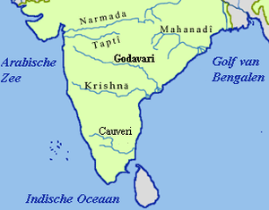
The geographical area of the district is 4,288 square kilometres (1,656 sq mi) and it is located at 18°41′N 78°6′E / 18.683°N 78.100°E.[6] Nizamabad is bounded on the North by Nirmal district, on the East by Jagtial and Rajanna Sircilla district, on the South lies Kamareddy district, and on the West by Nanded district of Maharashtra State. The Godavari River enters into Telangana from Nizamabad district at Kandhakurthi.
Demographics
As of 2011 Census of India, the district has a population of 1,571,022.[7] In 2006 the Indian government named Nizāmābād one of the country's 250 most backward districts (out of a total of 640).[8] It is one of the ten districts of Telangana currently receiving funds from the Backward Regions Grant Fund Programme (BRGF).[8]
In Nizamabad, male literacy is around 92.07% whilst the female literacy rate is 86.03%
Administrative divisions
The district is divided into 3 revenue divisions of Bodhan, Armoor and Nizamabad. These are sub-divided into 26 mandals and has 438 villages.[1] Yogita Rana is the present collector of the district.[9]
Mandals
The below table categorizes 27 mandals into their respective revenue divisions in the district:[10]
Mandals
| S.No. | Armoor revenue division | S.No. | Bodhan revenue division | S.No. | Nizamabad revenue division |
|---|---|---|---|---|---|
| 1 | Armoor | 1 | Bodhan | 1 | Nizamabad (South) |
| 2 | Balkonda | 2 | Yedapally | 2 | Nizamabad (North) |
| 3 | Mupkal | 3 | Renjal | 3 | Nizamabad Rural |
| 4 | Mendora | 4 | Kotagiri | 4 | Mugpal |
| 5 | Kammar palle | 5 | Varni | 5 | Dichpally |
| 6 | Velpur | 6 | Rudrur | 6 | Dharpally |
| 7 | Morthad | 7 | Indalwai | ||
| 8 | Bheemgal | 8 | Makloor | ||
| 9 | Jakranpally | 9 | Sirikonda | ||
| 10 | Nandipet | 10 | Navipet | ||
| 11 | Yergatla |
Constituencies
Parliamentary Constituency
Assembly Constituencies
There are 6 assembly constituencies in the district. They are, Armur, Bodhan, Banswada - Partly (Varni, Rudrur, Kotagiri Mandals), Nizamabad (Urban), Nizamabad (Rural), Balkonda
Transport
Roads
Nizamabad district has good road connectivity. Almost all the towns and villages in the district have well laid asphalt roads and are connected to district headquarters. Nizamabad has 2 National Highways passing through it, one being NH 44 which connects Kanyakumari and Varanasi and the other is NH16 which starts from Nizamabad and passes through Karimnagar to Jagadalpur in the state of Chhattisgarh.[11] The Telangana State Road Transport Corporation (TSRTC) runs around 700[12] buses from district headquarters on a daily basis.
Rail
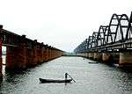
Nizamabad Railway Station is the major train station in the district which is located on Secunderabad-Manmad section of Hyderabad Division of the South Central Railway Zone (SCR). All the towns in the district have a rail network coverage and Nizamabad being one of the important stations on the line carters the need of the people. Jankampet Junction which lies in the west of Nizamabad city connects to Bodhan town.[13]
The Nizamabad-Peddapalli section connects Nizamabad with the Grand Trunk route of New Delhi-Chennai main line and the distance from Nizamabad to Karimnagar and Warangal reduced to a large extent.[14][15] This line also increased the railway network in the district and the northern cities of Telangana.
Education
Many engineering colleges are located in the district. Kshatriya College of Engineering, Armoor (KCEA) Vijay Rural Engineering College, Nizamabad (VREC), affiliated with Jawaharlal Nehru Technological University, Hyderabad (JNTUH) is the reputed engineering college located in Telangana. Kakatiya Institutions of Nizamabad is a group of institutions known for their excellence in state of Telangana and the erstwhile Andhra Pradesh.
Telangana University is a public university under the government of AP, located at Dichpally, 15 km from the city. There are many educational institutions that provide education namely VREC, Arkay College of Engineering and Technology,[16] Kshatriya College of Engineering,[17] Kakatiya Engineering College for Women, Government Medical College,[18] Nishitha Degree College, etc.
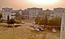
RGUKT, Basar popularly known as IIIT Basar is an autonomous institution located 35 km from Nizamabad. The official name of the institute is Rajiv Gandhi University of Knowledge Technologies. It offers six-year integrated B.Tech programme with three semesters every year for those passing SSC, for award of dual degrees in different specializations of engineering and science.[19]
Tourism
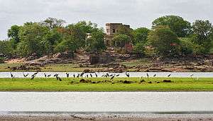
- Pocharam Wildlife Sanctuaryis a forest and wildlife sanctuary spread across 130 square kilometres (50 sq mi), between the districts of Nizamabad and Medak,[20] it was a former hunting ground of the Nizam that was declared a wildlife sanctuary in the early 20th century.
- Alisagar is 10 km (6.2 mi) from Nizamabad city and 2 km (1.2 mi) off the Nizamabad-Basar road.
Notable people
For people from Nizamabad city, not the surrounding district, please see Nizamabad
- Malavath Purna, a 13-year-old student from Sirkonda mandal, Nizamabad district became the youngest person to climb Mount Everest when she reached the peak on 25 May 2014. She was accompanied by Sadanapalli Anand, a 17-year-old student from Khammam.[21]
- Dil Raju is a Telugu cinema film-producer from Narsingpally, in Nizamabad district.
See also
References
- 1 2 3 "New districts". Andhra Jyothy.com. 8 October 2016. Retrieved 8 October 2016.
- ↑ "District Codes". Government of Telangana Transport Department. Retrieved 4 September 2014.
- ↑ ":: Welcome to Nizamabd.com ::".
- ↑ "History of Indur".
- ↑ "District Census Handbook - Adilabad" (PDF). Census of India. p. 9. Retrieved 20 November 2015.
- ↑ "Falling Rain Genomics, Inc – Nizamabād". Fallingrain.com. Retrieved 20 November 2012.
- ↑ http://www.trac.telangana.gov.in/district_plan.php
- 1 2 Ministry of Panchayati Raj (8 September 2009). "A Note on the Backward Regions Grant Fund Programme" (PDF). National Institute of Rural Development. Archived from the original (PDF) on 5 April 2012. Retrieved 27 September 2011.
- ↑ "K Chandrasekhar Rao appoints collectors for new districts". Deccan Chronicle. 11 October 2016. Retrieved 13 October 2016.
- ↑ "Clipping of Andhra Jyothy Telugu Daily - Hyderabad". Andhra Jyothy. Retrieved 8 October 2016.
- ↑ "North South East West Map". National Highway Development Project. Retrieved 16 June 2008.
- ↑ http://nizamabad.nic.in/code/atg.htm
- ↑ "NZB/Nizamabad (3 PFs) Railway Station - Today's Train Departure Timings - India Rail Info - A Busy Junction for Travellers & Rail Enthusiasts". India Rail Info.
- ↑ "Press Release". South Central Railway Zone. Indian Railways. Retrieved 29 October 2016.
- ↑ "Rail budget boost to 2 last-mile projects - Times of India". The Times of India. 28 February 2016. Retrieved 29 October 2016.
- ↑ Arkay College of Engineering & Technology
- ↑ "Welcome to Kshatriya College of Engineering".
- ↑ Nizamabad Medical College Meghana Dental College
- ↑ "Sonia to inaugurate IIIT at Idupulapaya today". The Hindu.
- ↑ http://forest.ap.nic.in/WL%20POCHARAM.htm
- ↑ "13-year-old Purna becomes youngest girl to scale Everest". The Times of India. 26 May 2014. Retrieved 27 May 2014.
External links
| Wikimedia Commons has media related to Nizamabad district. |
Places adjacent to Nizamabad district | |
|---|---|
| States | ||
|---|---|---|
| Union Territories | ||
| Related topics | ||