Pimpalgaon Raja
| Pimpalgaon Raja | |
|---|---|
| Village | |
| Nickname(s): P.Raja | |
 Pimpalgaon Raja Location in Maharashtra, India | |
| Coordinates: 20°43′00″N 76°26′00″E / 20.71667°N 76.43333°ECoordinates: 20°43′00″N 76°26′00″E / 20.71667°N 76.43333°E | |
| Country |
|
| State | Maharashtra |
| District | Buldana |
| Government | |
| • Type | Grampanchiyat |
| • Body | Grampanchiyat Members |
| Area rank | 1 |
| Population | |
| • Total | 15,234 |
| Languages | |
| • Official | Urdu,marathi |
| Time zone | UTC+5:30 (IST) |
| Vehicle registration | MH-28 |
Pimpalgaon Raja is a gram panchayat located in tahsil Khamgaon of Buldhana district of Maharashtra situated on bank of River Dnyanganga. It is 14 km from Khamgaon.Pimpalgaon Raja is a large village located in Khamgaon of Buldana district.
Geography
20° 43' 0" North, 76° 26' 0" south [1]
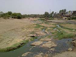
River Dnyanganga
Education
- Jilha Parishad Marathi Primary Girls School
- Jilha Parishad Marathi Primary School.
- Jilha Parishad High School And Junior College Pimpalgaon Raja
- Sahakar vidya Mandir Pimpalgaon Raja
- Jamia Ammar bin Yaseer Rz Pimpalgaon Raja
- Urdu High School & Junior College Pimpalgaon Raja
- Madarsah Deeniyat Taqiya Masjid
Agriculture
Agriculture is the primary economic activity in the town.[2]
Nearby Places
Places around Pimpalgaon Raja:[3]
- Tarwadi (9 km / 6 mi.Tarwadi is 292° West-northwest of Pimpalgaon Raja WNW)
- Goshing (12 km / 8 mi.Goshing is 262° West of Pimpalgaon Raja W)
- Nandura (13 km / 8 mi.Nandura is 8° North of Pimpalgaon Raja N, Pop. 39,650)
- Khamgaon (14 km / 9 mi.Khamgaon is 104° East Southeast of Pimpalgaon Raja ESE, Pop. 94,604)
References
This article is issued from
Wikipedia.
The text is licensed under Creative Commons - Attribution - Sharealike.
Additional terms may apply for the media files.