Warangal
| Warangal Greater Warangal | |
|---|---|
| City | |
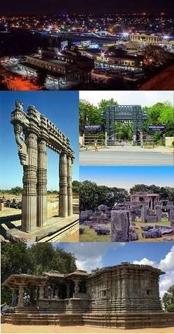 Clockwise from top: City view as seen from Govindarajula hill, Kakatiya University, Warangal Fort, Thousand Pillar Temple, Kakatiya Kala Thoranam | |
 Warangal  Warangal | |
| Coordinates: 18°00′N 79°35′E / 18.0°N 79.58°ECoordinates: 18°00′N 79°35′E / 18.0°N 79.58°E | |
| Country | India |
| State | Telangana |
| District |
Warangal Urban Warangal Rural |
| Other Names |
Orugallu Ekasila Nagaram Andhra Nagaram Warangal Tri-City |
| Founded | 1163 |
| Founded by | Kakatiya dynasty |
| Government | |
| • Type | Mayor-council |
| • Body |
GWMC KUDA |
| • Mayor | Nannapaneni Narender |
| • Municipal Commissioner | VP Gautham[1] |
| • Commissioner of Police | Vishwanath Ravinder[2] |
| Area[3] | |
| • City | 471 km2 (182 sq mi) |
| • Metro | 1,805 km2 (697 sq mi) |
| Elevation | 359 m (1,178 ft) |
| Population (2017)[3] | |
| • City | 819,406 |
| • Rank |
52nd(India) 2nd (Telangana) |
| • Density | 2,000/km2 (5,000/sq mi) |
| • Metro | 819,406 |
| Demonym(s) | Warangalite |
| Languages | |
| • Official |
|
| Time zone | UTC+5:30 (IST) |
| PIN | 506001 to 506019 [4] |
| Telephone code | +91–0870 |
| Vehicle registration | TS–03,TS-24,AP 36(old)[5] |
| Ethnicity | Indian |
| Website |
www |
Warangal ![]()
Along with 11 other cities in the country having rich culture and heritage, it has been chosen for the HRIDAY – Heritage City Development and Augmentation Yojana scheme by the Government of India.[6] It was also selected as a smart city in the "fast-track competition", which makes it eligible for additional investment to improve urban infrastructure and industrial opportunities under the Smart Cities Mission.[7]
Kakatiya Urban Development Authority (KUDA) was constituted by Government for the Planning , Development and Management of the Kakatiya (Warangal) Urban Development Area under the aegis of the Urban Areas (Development) Act,1975 vide G.O.Ms.No. 1177 M.A. dated 6-11-1981. KUDA is in the process of preparation of Master Plan for the horizon year 2041.
The region is spread over three districts – Warangal Rural, Warangal Urban and Jangaon in Telangana covering 19 Mandals and 181 Villages with total geographical of 1,805 Sq.km. Total population as per 2011 census is nearly
8 Lakhs. Urban Population share in the region is nearly 62%. The Master Plan is being prepared in accordance with the provisions of Telangana Urban Areas (Development) Act, 1975.
The KUDA/ Government of Telangana has appointed LEA Associates South Asia Pvt. Ltd. (LASA), India, A LEA Group Company, Canada, for Preparation of Master Plan for the KUDA Area. The Plan is aimed to be prepared in 9 months duration starting from July 2017.
Warangal served as the capital of the Kakatiya dynasty which was established in 1163. The monuments left by the Kakatiyas include fortresses, lakes, temples, and stone gateways helped the city to become a significant tourist attraction. The Kakatiya Kala Thoranam was included in the Emblem of Telangana by the state government.
[8]
The major Railway stations in the city are Kazipet Junction railway station and Warangal railway station.[8]
Areas In Greater Warangal
Greater Warangal Municipal Corporation (GWMC) Inclusion of 42 Gram Panchayats into the limits.
- Allipur
- Nakkalapally
- Ayhodhyapuram
- Tekulagudem
- Bhattupalli
- Taralapally
- Kadipikonda
- Thimmapur
- Kummarigudem
- Bheemaram
- Paidipally
- Devannapet
- Chinthagattu
- Hasanparthy
- Pegadapally
- Komatipally
- Yellapur
- Mucherla
- Mogilicherla
- Munipally
- Rampur
- Dharmaram
- Vanagapahad
- Dupakunta
- Gundlasingaram
- Gorrekunta
- Kothapeta
- Potharajpally
- Palivelpula
- Stambhampally
- Arepally
- Vasanthapur
- Enumamula
- Janpaka
- Gopalapuram
- Unikicherla
- Kothapally (H)
- Singaram
- Madikonda
- Bollikunta
- Mamunoor
- Gadepallly
Etymology
During Kakatiyan rule, Warangal was referred with various names like Orugallu, Ekasila Nagaram, or Omatikonda all these means a 'single stone' referring to a huge granite boulder present in the Warangal fort.[9] When the kakatiyan dynasty was defeated by Delhi Sultanate in 1323, ruler Juna khan conquered the city and renamed it as Sultanpur.[10] Later Musunuri Nayaks recaptured warangal in 1336 A. D. and named it Orugallu again.
History

Warangal was the ancient capital of kakatiya dynasty. It was ruled by many kings such as BetaRaja I, ProlaRaja I, BetaRaja II, ProlaRaja II, Rudradeva, Mahadeva, Ganapathideva, Prataparudra and Rani Rudrama Devi who is the only woman to rule over Telugu region. Beta Raja I is the founder of Kakatiya Dynasty and ruled the kingdom for 30 years and was succeeded by his son Prola Raja I who shifted his capital to Hanamkonda.[11]
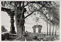
During the rule of Ganapathideva, the capital was shifted from Hanamkonda to Warangal.[12] Kakatiya Period Inscriptions praised Warangal as best city within all of Telugu region up to shores of the Ocean.[13] The Kakatiyas left many monuments, including an impressive fortress, four massive stone gateways, the Swayambhu temple dedicated to Shiva, and the Ramappa temple situated near Ramappa Lake. The cultural and administrative distinction of the Kakatiyas was mentioned by Marco Polo. After the defeat of Prataparudra II, the Musunuri Nayaks united 72 Nayak chieftains and captured Warangal from Delhi Sultanate and ruled for fifty years. After the demise of the Nayaks, Warangal was part of the Bahmani Sultanate and then the Sultanate of Golconda.
The Mughal emperor Aurangzeb conquered Golconda in 1687, and it remained part of the Mughal empire until the southern provinces of the empire split away to become the state of Hyderabad in 1724, which included the Telangana region and some parts of Maharashtra and Karnataka. Hyderabad was annexed to India in 1948, and became an Indian state called as Hyderabad state. In 1956 Hyderabad state was partitioned as part of the States Reorganisation Act, and Telangana, the Telugu-speaking region of Hyderabad state, which includes Warangal, became part of Andhra Pradesh. After the Telangana movement, Telangana state was formed on 2 June 2014, warangal became part of Telangana State.
Geography and climate
| Warangal | ||||||||||||||||||||||||||||||||||||||||||||||||||||||||||||
|---|---|---|---|---|---|---|---|---|---|---|---|---|---|---|---|---|---|---|---|---|---|---|---|---|---|---|---|---|---|---|---|---|---|---|---|---|---|---|---|---|---|---|---|---|---|---|---|---|---|---|---|---|---|---|---|---|---|---|---|---|
| Climate chart (explanation) | ||||||||||||||||||||||||||||||||||||||||||||||||||||||||||||
| ||||||||||||||||||||||||||||||||||||||||||||||||||||||||||||
| ||||||||||||||||||||||||||||||||||||||||||||||||||||||||||||


Warangal is located at 18°00′N 79°35′E / 18.0°N 79.58°E. It has an average elevation of 302 metres (990 feet). It is settled in the eastern part of Deccan Plateau made up of granite rocks and hill formations[14] which left the region barren making the cultivation depend on seasonal rainfalls. There are no river flows nearby warangal, which makes it to rely on Kakatiya Canal which originates from Sriram Sagar Project to meet the drinking water requirements.[15][16] Located in the semi-arid region of Telangana, Warangal has a predominantly hot and dry climate. Summer starts in March, and peak in May with average high temperatures in the 42 °C (108 °F) range. The monsoon arrives in June and lasts until September with about 550 mm (22 in) of precipitation. A dry, mild winter starts in October and lasts until early February, when there is little humidity and average temperatures in the 22–23 °C (72–73 °F) range. Many hill rocks and lakes are located around warangal. Padmakshi hill, mettu gutta, hanumathgiri gutta, ursu gutta and Govinda Rajula Gutta are famous hills with temples.[17]
Bhadrakali Lake, Dharmasagar lake and Waddepally Lake are the three famous lakes which adds scenic beauty and also are the major sources of drinking water.[18]
Governance

| Warangal city population | |||
|---|---|---|---|
| Census | Pop. | %± | |
| 1901 | 31,186 | — | |
| 1911 | 48,342 | 55.0% | |
| 1921 | 46,791 | -3.2% | |
| 1931 | 62,119 | 32.8% | |
| 1941 | 92,808 | 49.4% | |
| 1951 | 133,130 | 43.4% | |
| 1961 | 160,000 | 20.2% | |
| 1971 | 210,040 | 31.3% | |
| 1981 | 338,910 | 61.4% | |
| 1991 | 447,657 | 32.1% | |
| 2001 | 530,636 | 18.5% | |
| 2011 | 811,844 | 53.0% | |
| Sources:[19][20][21] | |||
Civic administration
Greater Warangal Municipal Corporation is the civic body of the city, which oversees the civic needs. The GWMC covers an area of 406.87 square kilometres (157.09 sq mi).[22][3] City planning is governed by the Kakatiya Urban Development Authority, which was constituted in 1982. The body oversees development of infrastructure and other projects in the city.[23]
The former Warangal Municipal Corporation implemented some pilot projects, such as the Solid Waste Management programme, that were so successful that other corporations have since implemented them.[24][25] The city is divided into 58 political wards where each ward is represented by an area corporator.
Law and order
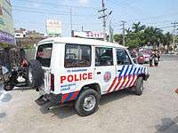
The urban police district, which is responsible for maintaining law and order in city and agglomerated areas around Warangal was converted into a Police Commissionerate by the state government in 2015.[26][27] Inspector General will be working as police commissioner who is also given magisterial powers. There are around 19 police stations present under Warangal Police Commissionerate.[28]
Healthcare
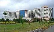
The 1000-bed Mahatma Gandhi Memorial Hospital is the largest hospital in the city. It also serves the needs of patients from the neighbouring districts of Khammam and Karimnagar.[29]
There are various public and private hospitals.[30]
Economy
As of 2011 census of India, Warangal is one of the Indian cities that has seen rapid growth of urbanisation from 19%–28%, alongside cities such as Gandhinagar, Kozhikode.[31]
Agriculture is the main economic activity with irrigation depending mainly on monsoon and seasonal rainfalls. Major crops are paddy, cotton, mango and wheat. Warangal benefits from the Godavari lift irrigation scheme which is designed to lift water from the Godavari river to irrigate drought prone areas in the Telangana region.[32]
The city hosts second-biggest grain market of Asia, located in Enumamula.[33] Information Technology is another sector in which the city is making steady progress with its Incubation centre at Madikonda.[34][35]
Transport

Roadway
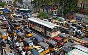
The city is connected to major cities and towns by means of road and railways. National and state highways that pass through the city are, National Highway 163, connecting Hyderabad and Bhopalpatnam; NH 563 connecting Ramagundam and Khammam; State highway 3. TSRTC operates buses to various destinations from Hanamkonda and Warangal bus stations of the city.[36] Nearly 78 City buses run in various routes across the city and sub urban areas while 45 city buses run from city to nearby villages.[37]
Railway
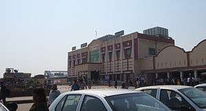
Warangal has two railway stations namely, Kazipet and Warangal on the important New Delhi-Chennai main line of Indian Railways.[38] They are administered under the jurisdiction of the Secunderabad railway division of South Central Railway zone. Kazipet Junction shelters both Electric and Diesel Loco sheds with a capacity of holding 175 and 142 locomotives.[39][40] Kazipet town, Vanchanagiri, Pendial, Hasanparthy Road railway station are the other railway stations within the city limits. The construction of third railway line between Balharshah and Kazipet was sanctioned at an estimated cost of ₹24.032 billion (US$330 million).[41]
Airway
Warangal has an airport built by the Nizams at Mamnoor in 1930. It was largest airport in undivided India with 1,875 acres of land, a 6.6-km runway, a pilot and staff quarters, a pilot training centre and more than one terminal. Many cargo services and Vayudoot services were served. During the Indo-China war, it served as a hangar for government aircraft due to Delhi airport being a target in combat. It remained in service until 1981.[42]
This airport is currently being used as NCC Training Centre by No. 4(A) air squadron for gliding sorties, skeet shooting and aero-modeling.[43] There is no scheduled commercial air service from this airport at present.
Education
Both government and private institutions has their presence in the city.
Colleges and universities:
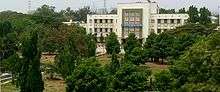
Kakatiya University and Kaloji Narayana Rao University of Health Sciences are two universities in the city. Other notable educational institutions include NIT Warangal, Kakatiya Institute of Technology and Science, Vaagdevi College of Engineering, SR Engineering College, and Kakatiya Medical College.
Culture
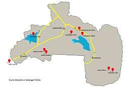
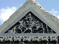
The residents of the city are often referred as Warangalites.[44] The Warangal Fort, Thousand Pillar Temple and Ramappa Temple are the World Heritage sites recognised by UNESCO.[45] Bhadrakali Temple, Padmakshi Temple, Kazipet Dargah, Mettu Gutta, Govinda Rajula Gutta, Ursu Gutta, and Erragattu Gutta are the other notable destinations of various religions. Bhadrakali Lake, Waddepally Lake, and Dharmasagar Lake are the water bodies notable for tourism.[46]

Bhadrakali Temple lake is being developed into the largest first Geo-Bio-Diversity cultural park in the country, with promenades, historic caves, suspension bridges, natural trails, nesting ground and ecological reserves.[47][48]
The Ministry of Tourism has awarded Warangal as the best heritage city, at the National Tourism Awards for the year 2014-2015.[49] This is third time in a row for the city to get this award since 2012.[50]
Festivals
Festivals in the city include, a floral festival of Bathukamma being celebrated by women of the city, worshiping the goddess with different flowers for nine days.[52] The women carry their Bathukamma to the nearest temple of their locality, then they clap, sing and dance rhythmically around the Bathukamma.[53] Along with Bathukamma, Bonalu is also declared as a state festival on 15 June 2014.[54] Other festivals are, Sammakka Saralamma Jatara (Medaram Jatara), a popular religious congregation in the honour of Goddess at Medaram of Warangal district.
Cuisine
The cuisine of the city is mainly of Deccan dishes. The breakfast items include Chapati, and Puri. Rice with variety of curries including curd is taken as main food and the most notable one is the Biryani. Special food items Harees and Haleem are traditional food items available in the season of Ramadan.[55]
Notable People
- P. V. Narasimha Rao, Prime Minister of India
- Tharun Bhascker Dhaassyam, film director
- Sandeep Reddy Vanga, film director
- Chandrabose (lyricist), Indian lyricist
- Chakri, music director
References
- ↑ "Municipal commissioner".
- ↑ "Commissioner of Police". Warangal.
- 1 2 3 "Physical details of GWMC" (PDF). gwmc.gov..in. p. 3. Retrieved 5 April 2017.
- ↑ http://www.indiapost.gov.in/imo_offices.aspx
- ↑ "District Codes". Government of Telangana Transport Department. Retrieved 4 September 2014.
- ↑ "Warangal | Heritage City Development and Augmentation Yojana (HRIDAY)". hridayindia.in. Retrieved 2016-07-13.
- ↑ "Lucknow, Warangal among 13 smart cities announced by govt". The Hindu. 2016-05-24. ISSN 0971-751X. Retrieved 2016-07-13.
- 1 2 "Warangal city may not be divided - TELANGANA". The Hindu. Retrieved 2017-12-16.
- ↑ http://hridayindia.in/warangal/
- ↑ https://books.google.co.in/books?id=K7ZZzk8cXh8C&pg=PA86&lpg=PA86&dq=warangal+named+as+sultanpur&source=bl&ots=GppHQYnrHT&sig=o3ehArB9iOBfbfMjtSGjlHHGp-M&hl=en&sa=X&ved=0ahUKEwjanZDf-JrVAhWIVZQKHT_lCxUQ6AEITDAG#v=onepage&q=warangal%20named%20as%20sultanpur&f=false
- ↑ http://www.importantindia.com/9551/kakatiya-dynasty/
- ↑ http://www.art-and-archaeology.com/india/warangal/wa01.html
- ↑ Cynthia, Talbot (2001-09-20). Precolonial India in Practice: Society, Region, and Identity in Medieval Andhra. Oxford University Pres. p. 37. ISBN 9780198031239.
- ↑ "Deccan Plateau, Andhra Pradesh – Things to do in Andhra Pradesh". Retrieved 28 July 2015.
- ↑ "Three towns in the grip of water crisis". The Hindu. Retrieved 28 July 2015.
- ↑ "Drinking Water". Archived from the original on 2 July 2014. Retrieved 28 July 2015.
- ↑ "About – Welcome to Padmakshi Temple". Retrieved 28 July 2015.
- ↑ D. Thhatikkonda. "Lake Water Quality and its Interaction with Aquifers in Warangal City". Retrieved 28 July 2015.
- ↑ Gopi, K.N (1978). Process of urban fringe development: A model. Concept Publishing Company. p. 25. Retrieved 6 August 2013.
- ↑ Iyer, Neelakantan Krishna; Kulkarni, Sumati; Raghavaswam, V. (13 June 2007). "Economy, population and urban sprawl a comparative study of urban agglomerations of Banglore and Hyderabad, India using remote sensing and GIS techniques" (PDF). circed.org. p. 21. Retrieved 10 December 2012.
- ↑ "Cities having population 1 lakh and above, census 2011" (PDF). Government of India. 2011. p. 11. Retrieved 10 December 2012.
- ↑ "Warangal Municipal Corporation, Budget 2014–15". Greater Warangal Municipal Corporation. Retrieved 4 February 2015.
- ↑ "Kakatiy Urban Development Au". Kuda.in. Retrieved 19 April 2014.
- ↑ Special Correspondent (11 October 2012). "Drive to keep Warangal clean". The Hindu. Retrieved 19 April 2014.
- ↑ "Warangal model for solid waste management". The Hindu. 20 June 2013. Retrieved 19 April 2014.
- ↑ "Warangal to Get Police Commissionerate". The New Indian Express.
- ↑ "వరంగల్.. ఇక పోలీసు కమిషనరేట్". Retrieved 28 July 2015.
- ↑ "Jurisdiction of Police Stations". Retrieved 28 July 2015.
- ↑ "MGM (Mahatma Gandhi Memorial) Hospital in Warangal – Sehat". Retrieved 28 July 2015.
- ↑ "Biomedical wastes pose a threat to lives". www.deccanchronicle.com.
- ↑ "High growth North yet to match spatial spread of South, West". The Indian Express. 7 April 2014. Retrieved 15 June 2014.
- ↑ "Detailed Profile Of The Project". Irrigation.cgg.gov.in. 23 May 2003. Archived from the original on 26 March 2014. Retrieved 19 April 2014.
- ↑ "Enumamula Village, Hanamkonda Mandal, Warangal". India Growing. Archived from the original on 26 March 2014. Retrieved 19 April 2014.
- ↑ Special Correspondent (3 February 2014). "STPI-Warangal woos investors". The Hindu. Retrieved 19 April 2014.
- ↑ Press Trust of India (19 February 2016). "IT Incubation Centre inaugurated in Warangal". Business Standard. Retrieved 5 July 2016.
- ↑ "Bus Stations". TSRTC. Retrieved 20 May 2016.
- ↑ "Guntur still awaits city RTC services". The Times of India. Retrieved 28 July 2015.
- ↑ "KARIMNAGAR-District Panchayat". Retrieved 28 July 2015.
- ↑ "ELS / KZJ". South Central Railway. Retrieved 15 October 2016.
- ↑ South Central Railway
- ↑ "New rail line between Kazipet and Ballarshah - Times of India". The Times of India. Retrieved 2016-10-15.
- ↑ "Nizam-era airport lies neglected - Times of India". Retrieved 2016-07-13.
- ↑ "Mamnoor airport to function only after 2030". Deccan Chronicle. 21 September 2014. Retrieved 15 October 2016.
- ↑ "Paying tribute to new State in style". The Hindu. 2 June 2015. Retrieved 15 October 2016.
- ↑ Centre, UNESCO World Heritage. "The Glorious Kakatiya Temples and Gateways - UNESCO World Heritage Centre". whc.unesco.org. Retrieved 28 June 2016.
- ↑ "Regions ::: Visit Telangana - Official Tourism Information for Telangana". www.telanganatourism.gov.in. Retrieved 28 June 2016.
- ↑ "Destination Warangal". The Hindu. 2015-08-06. ISSN 0971-751X. Retrieved 2016-07-13.
- ↑ http://timesofindia.indiatimes.com/city/hyderabad/Not-Hyderabad-Warangal-now-tourism-hotspot/articleshow/49351037.cms
- ↑ http://indianexpress.com/article/india/india-news-india/madhya-pradesh-received-award-for-comprehensive-development-of-tourism-2944373/
- ↑ http://www.thehindu.com/news/national/telangana/warangal-wins-best-heritage-city-award/article8927116.ece
- ↑ "Warangal City Population Census 2011 – Andhra Pradesh".
- ↑ Special Correspondent. "Bathukamma: Festivities in the air". The Hindu. Retrieved 28 July 2015.
- ↑ Gollapudi Srinivasa Rao. "Bathukamma festivities to begin from Sept. 24". The Hindu. Retrieved 28 July 2015.
- ↑ "Bonalu, Bathukamma declared state festivals". The Times of India. Retrieved 28 July 2015.
- ↑ "City Of Warangal » Harees popular than Haleem in Warangal". City Of Warangal. Retrieved 28 July 2015.
Further reading
External links
| Wikimedia Commons has media related to Warangal. |
