Ahmednagar
| Ahmednagar | |
|---|---|
| City | |
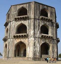 Tomb of Salabat Khan | |
 Ahmednagar | |
| Coordinates: 19°05′N 74°44′E / 19.08°N 74.73°ECoordinates: 19°05′N 74°44′E / 19.08°N 74.73°E | |
| Country |
|
| State | Maharashtra |
| District | Ahmednagar |
| Founded by | Ahmad Nizam Shah I in 1490. |
| Government | |
| • Type | Mayor–Council |
| • Mayor | Surekha Sambhaji Kadam (Shiv Sena) [1] |
| Area | |
| • Total | 39.30 km2 (15.17 sq mi) |
| Elevation | 649 m (2,129 ft) |
| Population (2011)[2] | |
| • Total | 350,905 |
| • Rank | 124th |
| • Density | 8,900/km2 (23,000/sq mi) |
| Demonym(s) | Nagarkar / Nagari (Marathi) |
| Languages | |
| • Official | Marathi |
| Time zone | UTC+5:30 (IST) |
| PIN | 414001 , 414003 |
| Telephone codethe | 0241 |
| Vehicle registration | MH 16,17 |
| Website |
ahmednagar |
Ahmednagar (![]()
Ahmednagar has several dozen buildings and sites from the Nizam Shahi period.[5] Ahmednagar Fort, once considered almost impregnable, was used by the British to house Jawaharlal Nehru (the first prime minister of India) and other Indian Nationalists before Indian independence. A few rooms there have been converted to a museum. During his confinement by the British at Ahmednagar Fort in 1944, Nehru wrote the famous book The Discovery of India.[6] Ahmednagar is home to the Indian Armoured Corps Centre & School (ACC&S), the Mechanised Infantry Regimental Centre (MIRC), the Vehicle Research and Development Establishment (VRDE) and the Controllerate of Quality Assurance Vehicles (CQAV). Training and recruitment for the Indian Army Armoured Corps takes place at the ACC&S.[7]
Ahmednagar is a relatively small town and shows less development than the nearby western Maharashtra cities of Mumbai and Pune. Ahmednagar is home to 19 sugar factories and is also the birthplace of the cooperative movement. Due to scarce rainfall, Ahmednagar often suffers from drought. Marathi is the primary language for daily-life communication. Ahmednagar has recently published a plan of developing the city by year 2031.[8]
History
The town Ahmednagar was founded in 1490 by Ahmad Nizam Shah I on the site of a more ancient city, Bhingar. With the breakup of the Bahmani Sultanate, Ahmad established a new sultanate in Ahmednagar, also known as Nizam Shahi dynasty.
It was one of the Deccan sultanates, which lasted until its conquest by Mughal emperor Shah Jahan in 1636. Aurangzeb, the last great Mughal emperor, who spent the latter years of his reign, 1681–1707, in the Deccan, died in Ahmednagar and his burial at (khultabad) near Aurangabad in 1707, and a small monument marks the site.
In 1759, the Peshwa of the Marathas obtained possession of the place from Nizam of Hyderabad and in 1795 it was ceded by the Peshwa to the Maratha chief Daulat Rao Sindhia. Ahmednagar was invaded by a British force under General Wellesley and captured. It was afterwards restored to the Marathas, but again came into the possession of the British in 1817, according to the terms of the Treaty of Poona.
Military base
Ahmednagar is home to the Indian Armoured Corps Centre & School (ACC&S), the Mechanised Infantry Regimental Centre (MIRC), the Vehicle Research and Development Establishment (VRDE) and the Controllerate of Quality Assurance Vehicles (CQAV). Training and recruitment for the Indian Army Armoured Corps takes place at the ACC&S. Formerly, the city was the Indian base of the British Army's Royal Tank Corps / Indian Armoured Corps, amongst other units. The town houses the second-largest display of military tanks in the world and largest in Asia.[9]
Geography
Climate
Situated in the rain-shadow region of the Western Ghats, Ahmednagar experiences primarily hot and dry climate through November to mid June.
| Climate data for Ahmednagar | |||||||||||||
|---|---|---|---|---|---|---|---|---|---|---|---|---|---|
| Month | Jan | Feb | Mar | Apr | May | Jun | Jul | Aug | Sep | Oct | Nov | Dec | Year |
| Average high °C (°F) | 29 (84) |
32 (90) |
36 (97) |
38 (100) |
38 (100) |
33 (91) |
29 (84) |
28 (82) |
29 (84) |
32 (90) |
30 (86) |
28 (82) |
32 (89) |
| Average low °C (°F) | 10 (50) |
12 (54) |
16 (61) |
21 (70) |
23 (73) |
23 (73) |
22 (72) |
22 (72) |
20 (68) |
18 (64) |
14 (57) |
10 (50) |
18 (64) |
| Average precipitation mm (inches) | 5 (0.2) |
3 (0.12) |
5 (0.2) |
10 (0.39) |
23 (0.91) |
132 (5.2) |
97 (3.82) |
69 (2.72) |
165 (6.5) |
56 (2.2) |
28 (1.1) |
8 (0.31) |
601 (23.67) |
| Source: Ahmednagar Weather | |||||||||||||
Demographics
As of 2011 Indian census,[10] Ahmednagar had a population of 347,549. Males constitute 53% of the population and females 47%. Ahmednagar has an average literacy rate of 84%, higher than the national urban average of 79.9%.[11] 10% of the population is under 6 years of age.
People
- Sant Dnyaneshwar, Marathi sant, wrote Dnyaneshwari, a discourse on the Bhagavad Gita.
- Sai Baba of Shirdi, spiritual master
- Anand Rishiji, Jain saint
- Meher Baba, spiritual leader
- Chand Bibi, Nizamshahi princess, defended Ahmednagar Fort against the Mughal forces of Emperor Akbar
- Anna Hazare, Gandhian and social activist
- Shahu Modak, film actor
- Sadashiv Amrapurkar, noted film and theater actor
- Michael J. S. Dewar, theoretical chemist
- Anna Leonowens, educator, feminist, author of The English Governess at the Siamese Court (1870)
- Pramod Kamble, painter and sculptor
- Zaheer Khan, cricketer
- Ajinkya Rahane, cricketer
- Spike Milligan, 1918-2002, comedian and author
- Cynthia Farrar, American missionary
Main sights
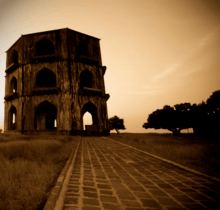
- Chand Bibi Palace - Actually the tomb of Salabat Khan,[12] this is a solid three-storey stone structure situated on the crest of a hill 13 km from Ahmednagar city.
- Meherabad, where the samadhi (tomb) of the spiritual master Meher Baba is a place of pilgrimage, visited by thousands each year, particularly on the anniversary of his death, Amartithi. His later residence was at Meherazad (near Pimpalgaon village), approximately nine miles north of Ahmednagar.
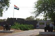
- Ahmednagar Fort (Bhuekot Killa) - Built by Ahmed Nizam Shah in 1490, this is one of the best-designed and most impregnable forts in India. As of 2013, it is under the control of the military command of India. Oval in shape, with 18-metre-high walls and 24 citadels, its defence system includes a moat 30 metres wide and 4 to 6 metres deep. Two entrances to the fort are accessed by drawbridges. A target of countless invasions, the Ahmednagar Fort has taken many blows and come out relatively unscathed. It has changed hands many times over from the time of Mughal rule, and was used as a royal prison a number of times. The entire Congress Working Committee was detained there during the Quit India Movement of 1942. Jawaharlal Nehru, later to be India's first prime minister, wrote his book The Discovery of India during his imprisonment from 1942-1945. Some rooms in the fort have been converted into a museum in commemoration of Nehru and other freedom fighters.[13]
- Cavalry Tank Museum - The Armoured Corps Centre and School has created a museum with an extensive collection of 20th-century armoured fighting vehicles.[14]
- Vishal Ganpati Mandir - Ganeshji Big temple in the Maliwada area of Ahmednagar City.
- Renuka/Durga Goddess Temple - This temple is located in Kedgaon (around 3 km from Ahmednagar Railway Station, 5 km from Ahmednagar ST bus-stand) which is near Nagar-Pune highway. The Navaratri (nine nights) festival is a celebration of nine nights of battle between the Goddess Durga and demon-king Mahishasura. Eventually Goddess Durga killed Mahishasura on the ninth night and thus the festival signifies the triumph of good over evil.
- Rehekuri Blackbuck Sanctuary: This is situated in Karjat taluka in Ahmednagar district. The area of the sanctuary is 2.17 km2.[15]
- Siddhatek Siddhivinayak - Temple of God Ganesh.
- Shirdi - The hamlet blessed by the revered Saint Sai Baba, revered by Hindus and Muslims alike, about 83 km from Ahmednagar City.
 Samadhi of Meher Baba
 - Ralegan Siddhi - a village which is a model for environmental conservation. Social activist Anna Hazare is from Ralegan Siddhi.
- Pimpri Gawali- is a village in Parner taluka in Ahmednagar district. It is located about 25 km away from Ahmednagar and it is well known for the watershed development and agribusiness activities. This village has done very basic work in the rain water harvesting through Deep CCT structures and groundwater regulation and management. Farmers self Help groups of the villages formed Producer Company for the value addition of their agricultural commodity. This village has conserved environment through participatory approach.
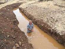 Deep Continuous Contour Trenches (CCT)
 - Shingnapur - A village containing a Shani (planet Saturn) temple and where all the houses are doorless—probably the only village in the world where locks are unnecessary.
- Harishchandragarh - a hill fort.
- Avhane, Shevgaon - Temple of Ganesh (Nidrista/Sleeping).
- Shri Munjaba Tample, Ukkadgaon- In Shrigonda Taluka about 60 km from Ahmednagar main city Its very beautiful Temple with four big statue of ganapati, mahadev (shankar), vinshnu and hanuman on Temple and thousands of devotees visit this place.
- Jamgaon- Place in Parner taluka with a historic 18th-century palace built by Mahadaji Shinde.
- Shree Kshetra Korthan Khandoba Devastan Temple of Lord Khandoba.
- Mahatma Phule Krishi Vidyapeeth, Rahuri Mahatma Phule Krishi Vidyapeeth is an agricultural university at Rahuri, named after an activist and social reformer of 19th century—one of four agricultural universities in the state.[16]
Transport
Air
Ahmednagar city have air connectivity by Seaplane service. The port for Seaplane is located at Mula Dam water reservoir, 30 min away from Ahmednagar City. The service offered by Maritime Energy Heli Air Services Pvt. Ltd. (MEHAIR) from 22 September 2014. On going Flight is available from Juhu, Mumbai to Mula Dam. The service will now enable the large number of pilgrims traveling to the holy sites of Meherabad, Shirdi and Shani Shingnapur to travel quickly and conveniently to their destinations. Now new airport have started at Shirdi which is 80 km from Ahmednagar and the only airport in the district. Regular flights from Mumbai, Delhi and Hyderabad fly to Shirdi. Currently, it is served by Air India and SpiceJet.
Rail
Ahmednagar railway station (station code:ANG) belongs to Solapur Division of Central Railway zone of the Indian Railways. Ahmednagar has rail connectivity with Pune, Manmad, Kopargaon, Shirdi, Daund, Goa, Nasik and other metro-cities like New Delhi, Mumbai, Chennai, Kolkata, Bangalore, Ahmedabad. 41 express trains stop at this station. There is still a demand for direct rail connectivity to other major cities of India.
Road
Ahmednagar is well connected by roads with major cities of Maharashtra and other states. Ahmednagar has 4 lane road connectivity to Aurangabad, Parbhani, Pune, Nashik, Beed, Solapur, Osmanabad.National Highway 222 from Kalyan to Nirmal near Adilabad in Telangana passes through the city. The Maharashtra State Road Transport Corporation (MSRTC) and different private transport operators provides bus service connecting the city to all parts of the state.
Ahmednagar has 3 main bus stands:
Politics
Ahmednagar Municipal Council was upgraded to Municipal Corporation status in 2003. As of July 2016, Surekha Kadam of Shiv Sena was the incumbent mayor. Ahmednagar city is represented in the central and state legislatures by the Ahmednagar Lok Sabha and Ahmednagar City Vidhan Sabha seats respectively. The Sitting MP is Dilipkumar Gandhi, while Sangram Jagtap is Ahmednagar MLA.
Media and communication
- Newspapers: Lokmat, Sakaal,Sarvamat,Deshdoot,Punyanagri, Samana, Loksatta, Nava Maratha, Nagar Times, Divya Marathi, Maharashtra Times, Samachar, Savedi Mitra
- TV Channel: CMN Channel
- Radio: 104 MY FM, AIR Nagar FM, Radio City, Dhamaal 24, Radio Nagar FM
- Internet: Internet facilities are provided by several suppliers
References
- ↑ "सेनेचा 'गनिमी कावा'; नगरचे महापौरपद जिंकले".
- ↑ "Cities having population 1 lakh and above" (PDF). censusindia. The Registrar General & Census Commissioner, India. Retrieved 29 December 2012.
- 1 2 The Kingdom of Ahmadnagar. Motilal Banarsidass Publ. 1966. p. 38. ISBN 978-81-208-2651-9.
- ↑ Sen, Sailendra (2013). A Textbook of Medieval Indian History. Primus Books. pp. 118–119. ISBN 978-9-38060-734-4.
- ↑ Sohoni, Pushkar (2015). Aurangabad with Daulatabad, Khuldabad, and Ahmadnagar. London; Mumbai: Deccan Heritage Foundation; Jaico. ISBN 9788184957020.
- ↑ Moraes, Frank (1 January 2007). Jawaharlal Nehru. Jaico Publishing House. p. 319. ISBN 978-81-7992-695-6.
- ↑ Sainik Samachar: The Pictorial Weekly of the Armed Forces. 1988. p. 14.
- ↑ Nagarick (6 June 2007). "Ahmednagar by year 2031". Nagarick.blogspot.com. Retrieved 2011-11-23.
- ↑ "The History of Ahmednagar". Ahmednagar.nic.in. 15 August 1947. Archived from the original on 7 October 2011. Retrieved 23 November 2011.
- ↑ "Census of India 2001: Data from the 2001 Census, including cities, villages and towns (Provisional)". Census Commission of India. Archived from the original on 2004-06-16. Retrieved 2008-11-01.
- ↑ Ministry of Home Affairs, Government of India, "2001 Literacy Rates", Census of India 2001, Ministry of Home Affairs, India
- ↑ Ahmednagar City at ahmednagar.nic.in
- ↑ Rajendra Rajan Fort that held Nehru The Tribune, 12 July 2009
- ↑ Tank Museum at ahmednagar.nic.in
- ↑ Maharashtra Forest Department Official website
- ↑ Maharashtra Krishi Vidyapeeth, Rahuri Archived 6 September 2013 at the Wayback Machine. Official website
- ↑ "ahmednagar bus stand - Google Search". www.google.co.in. Retrieved 2017-10-26.
- ↑ "Bus Stands & Traffic Control Centers Ahmednagar".
External links
| Wikimedia Commons has media related to Ahmednagar. |
- Ahmednagar: Places to Visit

- Ahmednagar Bus Stands Center Contact list
| Topics | |||||||||||||
|---|---|---|---|---|---|---|---|---|---|---|---|---|---|
| Regions | |||||||||||||
| Divisions and Districts |
| ||||||||||||
| Million-plus cities in Maharashtra | |||||||||||||
| Other cities with municipal corporations | |||||||||||||
Portal: Maharashtra | |||||||||||||