National Highway 16 (India)
| |
|---|---|
.jpg) Schematic map of Renumbered National Highways in India | |
| Route information | |
|
Part of | |
| Length | 1,711 km (1,063 mi) |
| Major junctions | |
| North end | Dankuni, Kolkata, West Bengal |
|
List
| |
| South end | Chennai, Tamil Nadu |
| Location | |
| States |
Odisha: 488 km Andhra Pradesh: 1,024 km Tamil Nadu: 45 km |
| Primary destinations | Kolkata (Junction of NH 6) – Balasore – Bhubaneswar – Brahmapur - Visakhapatnam – Eluru - Vijayawada – Guntur - Nellore – Chennai |
| Highway system | |
National Highway 16 (NH 16) is a major National Highway in India, that runs along east coast of West Bengal, Odisha, Andhra Pradesh and Tamil Nadu.[1] It was previously known as National Highway 5.
The northern terminal starts at Kharagpur National Highway 19 near Kolkata and the southern terminal is at Chennai in Tamil Nadu. It is a part of the Golden Quadrilateral project undertaken by National Highways Development Project.[2][3]
Route
Many cities and towns in various districts in the States of West Bengal, Odisha, Andhra Pradesh and Tamil Nadu are connected by National Highway 16. NH 16 has a total length of 1,711 km (1,063 mi) and passes through the states of West Bengal, Odisha, Andhra Pradesh and Tamil Nadu.[4]
Route length in states:[5]
- West Bengal: 188 km (117 mi)
- Odisha: 457 km (284 mi)
- Andhra Pradesh: 1,028 km (639 mi)[3]
- Tamil Nadu: 53 km (33 mi)
_at_Visakhapatnam.jpg) NH 16 view at Visakhapatnam
NH 16 view at Visakhapatnam NH-16 near Mangalagiri
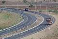 NH-16 near Ongole
 NH-16 in Tamil Nadu
See also
References
- ↑ "National Highways Development Project Map". National Highways Authority of India. Retrieved 21 April 2017.
- ↑ "Rationalisation of Numbering Systems of National Highways" (PDF). New Delhi: Department of Road Transport and Highways. Retrieved 3 April 2012.
- 1 2 "List of National Highways passing through A.P. State". Roads and Buildings Department. Government of Andhra Pradesh. Archived from the original on 28 March 2016. Retrieved 11 February 2016.
- ↑ "National highway 16 route substitution notification dated September, 2015" (PDF). The Gazette of India - Ministry of Road Transport and Highways. Retrieved 10 Aug 2018.
- ↑ "National Highways and their length" (pdf). report. National Highway Authority of India. Retrieved 8 July 2016.
External links
| Wikimedia Commons has media related to NH 5 (India). |

Secondary routes of National Highway 16 | ||
|---|---|---|
 | ||
| Secondary Routes of NH 16 | ||
This article is issued from
Wikipedia.
The text is licensed under Creative Commons - Attribution - Sharealike.
Additional terms may apply for the media files.