Koraput
| Koraput | |
|---|---|
| Town | |
  From Top; Left to Right: Deomali Mountain range, Gupteshwar Cave, Duduma Waterfalls, Tribes of Koraput and Rail Tracks in Koraput. | |
| Nickname(s): Aero Engine Capital of India[1] | |
 Koraput Location in Odisha, India  Koraput Koraput (India) | |
| Coordinates: 18°51′22″N 82°44′05″E / 18.8561°N 82.7347°ECoordinates: 18°51′22″N 82°44′05″E / 18.8561°N 82.7347°E | |
| Country |
|
| State | Odisha |
| District | Koraput |
| Government | |
| • Type | Municipality |
| • Body | Koraput Municipality |
| • Member of Parliament | Jhina Hikaka, (BJD) |
| • Member of Legislative Assembly | Krishna Chandra Sagaria, (INC) |
| Elevation | 870 m (2,850 ft) |
| Population (2011) | |
| • Total | 47,468 |
| Languages | |
| • Official | Odia |
| Time zone | UTC+5:30 (IST) |
| Vehicle registration | OD 10 |
| Website |
odisha |
Koraput is a town and a Municipality in Koraput district in the Indian state of Odisha. Koraput town is the district headquarter of Koraput district.
History
The district of Koraput derives its name from its headquarters the present town of Koraput. In ancient times when the Nalas were ruling over this tract, Pushkari near modern Umarkot was the capital city. In the medieval period Nandapur developed as the capital under the Silavamsi kings and sometimes under the kings of the Solar dynasty. Vikram Dev of the Solar dynasty shifted his headquarters to Jeypore about the middle of the 17th century and this town prospered as the capital. Koraput was chosen by the British in 1870 for better health prospects. The origin of the name of Koraput is obscure. There are several theories, none of which are convincing.
According to Mr. R.C.S.Bell the name of the town is ‘Kora-Putti’ or "the hamlet of the nux-vomica" and it is derived presumably from a tree or trees that must at one time have been prominent near the site. But today not a single tree of nux-vomica is to be found near about the town of Koraput and so the assumption or Mr. Bell is open to question.
According to second theory, Koraput is corrupted form of ‘Karaka pentho’ Karaka literally mans ‘hail-stone’. It is also believed that one ‘Khora Naiko’ laid foundation of the village during the time of Nandapur kings. He hailed probably from Ranpur and served under the Nandapur kings in the Militia, and for his faithful and meritorious services he has permitted to establish this village which was named after him as Khora Putu, and later on the name has been abbreviated to ‘Koraput’.
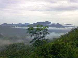
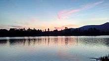
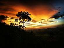
Koraput is also a Tourism Place. The town is surrounded by mountains, thick forests and waterfalls.
Marking a social success for others to emulate, the past two years, around 220 tribal villagers of the non-descript Bondaguda village under Similiguda block in the district has become totally free of open defecation with each of its 45 families constructing toilets in their homes.
Adivasi communities

Koraput is a part of the tribal belt in southern Odisha. As the term 'tribal' often denotes a negative connotation, the indigenous people here prefer to be known as Adivasis, i.e. "original inhabitants".[2] Many different Adivasi communities live in this district.
The traditional culture (including languages), knowledge and subsistence of the Adivasis are closely connected with local ecosystems.[3]
Most of the area was covered by thick forest until relatively recently. As a result of deforestation, industrialization and urbanization, many Adivasi communities have adopted new ways of life. However, many Adivasis maintain a tradition of selling produce (vegetables and fruit) in Sunday markets popularly known as Hat Poda (or haat).[4]
The Dongar Festival (or Parab) is held annually, ostensibly to showcase the way of life of Adivasis, in the first and second weeks of December, organised by the district administration. Many foreign tourists visit the festival.[5] There has been criticism of the festival, with allegations that Adivasis are reluctant participants, who are paraded like "museum specimens" for the benefit of the tourism industry.
Sabara Srikhetra (Jagannath Temple)
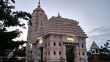
Koraput is mostly famous for its Jagannath Temple which is also known as Sabara Srikhetra. Srikhetra is normally referred to as Puri Jagannath, but the unique identity of the Koraput temple is because of the fact that no section of the society is barred entry.
Council of Analytical Tribal Studies (COATS), registered under the Societies Registration Act 1860,[6] is university–like educational institute is a successful attempt to restore and educate tribal way of life, customs, tradition, medicine, language, social structure and history. COATS has been documenting the day-today situation of poor tribals and feeding this information to the local administration in an effort to make it more efficient.
Geography

Koraput is located at 18°49′N 82°43′E / 18.82°N 82.72°E.[7] It has an average elevation of 870 m (2,850 ft).
Some major rivers of Odisha pass through the district Koraput like Machhakunda, Vamsadhara and Kolab. This district is also bestowed with waterfalls like Duduma, Bagra and Khandahati. It also contains the largest mountain of Odisha, called Deomali along with Chandragiri mountain. Koraput district is famous for the important places like Jeypur, Duduma, Bagra, Sunabeda MiG factory.Koraput holds a total area of 8,807 km2. As of 2011 census, with a total population of 13,79,647, the district has a literacy rate of 36.20%. Koraput is dependent on agricultural activities. The district has total cultivable land of 301,000 hectares (740,000 acres). With a 157 km long national highway the district is well connected to all the other districts of Odisha. Gupteswar, Neelabadi, Nandapur, Sunabeda, Duduma water fall, (Savra shrikhetra), Ankadeli forms the major interests of Koraput.
Hill stations
Being at the heart of tribal belt in South Odisha, it has also many hill stations though they are not that famous as other hill stations of India. Places like Machkund, Onukadelli, Jalaput, Chindri, Hatipathar,(Deomali) Potangi etc. are places to be visited for their scenic beauty .
Renowned Companies
Hindustan Aeronautics Limited, Engine Division (Su-30 MkI and MiG engine), located at Sunabeda. National Aluminium Company Limited, located at Damanjodi. South Orissa Voluntary Action (SOVA), located at Koraput.
Climate
| Climate data for Koraput, Odisha | |||||||||||||
|---|---|---|---|---|---|---|---|---|---|---|---|---|---|
| Month | Jan | Feb | Mar | Apr | May | Jun | Jul | Aug | Sep | Oct | Nov | Dec | Year |
| Average high °C (°F) | 25.3 (77.5) |
28.4 (83.1) |
31.7 (89.1) |
33.6 (92.5) |
34.3 (93.7) |
30.6 (87.1) |
25.9 (78.6) |
25.6 (78.1) |
26.6 (79.9) |
27.0 (80.6) |
25.7 (78.3) |
24.7 (76.5) |
28.3 (82.9) |
| Average low °C (°F) | 12.0 (53.6) |
14.4 (57.9) |
17.7 (63.9) |
20.9 (69.6) |
22.9 (73.2) |
22.5 (72.5) |
20.7 (69.3) |
20.4 (68.7) |
20.3 (68.5) |
18.7 (65.7) |
14.1 (57.4) |
11.5 (52.7) |
18 (64.4) |
| Average rainfall mm (inches) | 8 (0.31) |
3 (0.12) |
19 (0.75) |
53 (2.09) |
84 (3.31) |
213 (8.39) |
437 (17.2) |
391 (15.39) |
247 (9.72) |
116 (4.57) |
27 (1.06) |
8 (0.31) |
1,606 (63.22) |
| Source: en.climate-data.org | |||||||||||||
Economy
The Engine division of Hindustan Aeronautics Limited (HAL), a defence enterprise of the Government of India, is located at Sunabeda, 15 km from Koraput town. This factory manufactures aircraft engines for MiG and Sukhoi fighter aircraft. The HAL factory employs 6,000 engineers and technicians, all of whom reside in the township next to the factory.
The National Aluminium Company Ltd. (NALCO) mining and refinery complex at Damanjodi also has a significant contribution to the economy of Koraput district. Around 2,500 engineers and technicians are engaged in the process of extraction of Alumina from Bauxite. Other than the NALCO employees, there are thousands of workers engaged by hundreds of contractors who are employed here. The nearby town of Semiliguda has developed as a commercial centre of the district and has become a good market catering to the people of Semiliguda as well as of nearby Sunabeda and Damanjodi. Semliguda is mostly inhabited by trading communities.
Transport
Koraput has good linkage with other parts of the state as well as some major cities of neighboring states, by means of rail and road. National highway number 26(43) passes through the town which connects it with Raipur and Visakhapatnam. Buses are a plenty from Visakhapatnam and Vijayanagaram to Koraput. Buses to Jeypore, Jagdalpur, Umerkote, etc., also passes through Koraput.
Koraput railway station connects Koraput with Rayagada, Visakhapatnam, Berhampur, Jagdalpur, Howrah, Bhubaneswar, Rourkela and Raipur.
Also new proposed Biju Expressway will connect this city with Rourkela.
Administration
Koraput district is divided into 2 sub-divisions and 14 blocks. The 2 sub-divisions are Koraput and Jeypore
Blocks in Koraput sub-division 1. Koraput 2. Semiliguda 3. Nandapur 4. Pottangi 5. Dasmanthpur 6. Lamtaput 7. Laxmipur 8. Narayanapatna 9. Bandugaon
Blocks in Jeypore sub-division 1. Jeypore 2. Boipariguda 3. Kotpad 4. Kundra 5. Boriguma
Education
Koraput is well equipped with basic educational facilities. The major government and privately owned schools and college include :
- SLN Medical College and Hospital
- Siddharth Institute of Engineering and Technology (SIET) Koraput.
- Vyomayana Samstha Vidyalaya, Sunabeda, Koraput
- Aeronautics College, Sunabeda; (Previously named Aeronautics Commerce and Arts (A.C& A) College)
- Sunabeda Women's Junior College, Sunabeda, Koraput;
- Sunabeda Women's Degree College, Sunabeda, Koraput;
- Govt. High School (previously named Govt. Boys High School);
- Police High School, Koraput;
- J.E.L.C High School;
- Govt Girls High School, Koraput;
- Sahid Rajeev Gandhi High School, Sunapur, Koraput
- Sri Aurobindo Purnanga Shikhsakendra, Koraput;
- Saraswati Shishu Vidya Mandir, Koraput;
- Public School koraput;
- Kendriya Vidyalaya Koraput
- Kendriya vidyalaya NAD Sunabeda
- S.V.B.Vidyapith Eng. Medium School;
- Bikash Vidyalaya Eng / Oriya Medium School;
- Saints English Medium School, Koraput.
- Samanta Chandrashekhar Institute of Technology and Management, Semiliguda(SCITM)
- IEM Group Of Institutions, Jeypore
- Institute of Engineering and Management, Jeypore (I.E.M)
- Gopal Krishna college of Engineering and Technology, Jeypore (G.K.C.E.T)
- IEM Industrial Training Centre (ITI)
- Netaji English Medium School, semiliguda
- Central University of Orissa, Koraput
- Talents College Of Science& Technology, koraput
- Jawahor Navodaya Vidyalaya, Koraput
- Council of Analytical Tribal Studies
- Sunshine Computer Education(ISO9001-2008), Padua(Banjalaput), Nandapur, Koraput
- Jeevan Jyothi Convent School, Semiliguda, Koraput
As far as higher studies are concerned, Koraput has got one Woman's College and a D.A.V. College, both of which are affiliated to Berhampur University.
Apart from traditional courses, Koraput now also provides facilities for professional courses like engineering and pharmacy. There is a demand from the people of Koraput to establish a medical college in the district which has not been entertained by the Government.Koraput is surrounded with industry like HAL, NALCO, and other like power project, which create a demand for technical professionals.
In 2009, a central university was set up in Koraput namely Central University of Orissa. This started functioning from August 2009 providing courses on English, Oriya, Mass Communication, Journalism, Anthropology and Sociology. Prof Surabhi Banarjee has been appointed as the first Vice Chancellor of the University.[8]
On 4 September 2017 the new government medical college was established in koraput and named after Saheed Laxman Nayak, a great freedom fighter of that region. Classes started in September 2017.
Demographics
An official Census 2011 detail of Koraput, a district of Odisha has been released by Directorate of Census Operations in Odisha. Enumeration of key persons was also done by census officials in Koraput District of Odisha.
As per 2011 census,[9] Koraput had population of 47,468 of which male and female were 24,553 and 22,915 respectively. There was change of 16.63 percent in the population compared to population as per 2001 in Koraput District. In the previous census of India 2001, Koraput District recorded increase of 14.67 percent to its population compared to 1991.
The initial provisional data suggest a density of 156 in 2011 compared to 134 of 2001. Total area under Koraput district is of about 8,807 km2.
Average literacy rate of Koraput in 2011 was 49.87 compared to 35.72 of 2001. Gender wise, male and female literacy were 61.29 and 38.92 respectively. For 2001 census, same figures stood at 47.20 and 24.26 in Koraput District. Total literate in Koraput District were 579,203, of which male and female were 348,447 and 230,756 respectively. In 2001, Koraput District had 350,044 in its total region.
With regards to Sex Ratio in Koraput, it stood at 1031 per 1000 male compared to 2001 census figure of 999. The average national sex ratio in India is 940 as per latest reports of Census 2011 Directorate.
- Population of 2011 is 1,376,934
- Male 677,864
- Female 699,070
- Proportion to Odisha Population is 3.28%
Politics
Current [Member of Parliament(MP)] Mr. Jhina Hikka and MLA from Koraput Assembly Constituency is Mr.Krushna Chandra Sagaria who won the seat in State elections in 2014. Previous MLAs from this seat were Raghuram Padal of BJD from 2009 to 2014, Gupta Prasad Das of INC. in 1994, Harish Chandra Baxipatra who won as JD candidate in 1990 and as JNP candidate in 1977, Narusinghananda Brahma as INC. candidate in 1985, as INC.(I) candidate in 1980 and Taraprasad Bahinipati (INC) in 2000 and 2005.[10]
Koraput is part of Koraput (Lok Sabha constituency).[11]
See also

- Koraput District
References
- ↑ PTI (6 December 2014). "Koraput to be nurtured as Aero Engine Capital of India: Raha". OdishaTV. Retrieved 31 July 2018.
- ↑ http://www.pucl.org/Topics/Dalit-tribal/2003/adivasi.htm
- ↑ Franco F, Merlin; Narasimhan, D (2009). "Plant names and uses as indicators of knowledge patterns" (PDF). Indian Journal of Traditional Knowledge. 8 (4): 645–648.
- ↑ Resource: Book on the ethnobotany of the Kondh, Poraja, Gadaba and Bonda of the Koraput region of Odisha, India « Traditional Knowledge Bulletin. Tkbulletin.wordpress.com (2012-01-18). Retrieved on 2013-02-09.
- ↑ Parab - About. Koraput.nic.in (2009-11-18). Retrieved on 2013-02-09.
- ↑ Tribal Women, a Gendered Utopia?: Women in the Agriculture Sector, p. 25, Asha Hans, South Asian Publishers
- ↑ Falling Rain Genomics, Inc. - Koraput. Fallingrain.com. Retrieved on 2013-02-09.
- ↑ Central University. Cuorissa.org. Retrieved on 2013-02-09.
- ↑ http://www.censusindia.gov.in/pca/SearchDetails.aspx?Id=446965
- ↑ "State Elections 2004 - Partywise Comparison for 85-Koraput Constituency of Odisha". Election Commission of India. Retrieved 2008-09-13.
- ↑ "Assembly Constituencies - Corresponding Districts and Parliamentary Constituencies of Odisha" (PDF). Election Commission of India. Archived from the original (PDF) on 4 March 2009. Retrieved 2008-09-13.
- Koraput Parikrama, (Prabandha Samkalan), Published by Banaphula Sahitya Parishad, Sunabeda and edited by Dr. Basanta Kishore Sahoo
- Smaranika-2013 (Koraput Bisesanka), Published by Utkal Sanskrutika Parishad, Sunabeda and also edited by Dr. Basanta Kishore Sahoo
External links
| Wikisource has original text related to this article: |
- Deomali – The highest & largest mountain peak of Odisha
- Official GIS Maps of Koraput District
- Road Map of Koraput District
- Official website of Koraput district
- Check More about Beauty of Koraput
- Koraput district map
- Koraput district info
- Koraput district information
- Central University of Orissa
- Koraput village sets hygiene example
- Koraput Tourism