Bijapur district, Chhattisgarh
| Bijapur district | |
|---|---|
| District of Chhattisgarh | |
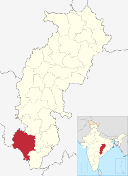 Location of Bijapur district in Chhattisgarh | |
| Country | India |
| State | Chhattisgarh |
| Administrative division | Bastar |
| Headquarters | Bijapur |
| Tehsils | 4 |
| Area | |
| • Total | 6,562.48 km2 (2,533.79 sq mi) |
| Population (2011) | |
| • Total | 2,55,180 |
| • Density | 39/km2 (100/sq mi) |
| Demographics | |
| • Literacy | 41.58% |
| • Sex ratio | 982 |
| Major highways | NH-16 |
| Average annual precipitation | 1517 mm |
| Website | Official website |
Bijapur District, formerly known as Birjapur, is one of the 27[1] districts of the state of Chhattisgarh in central India. It is one of the two new districts created on May 11, 2007. As of 2011 it is the second least populous district of Chhattisgarh (out of 18), after Narayanpur. It is the second-least literate district in India, with a literacy rate of at 41.58%, according to the 2011 census. Madhya Pradesh[2]
The present collector of Bijapur is Shri Ayaj Tamboli.[3]
History
Bijapur District was formerly part of the Dantewada district. It is currently a part of the Red Corridor.[4]
Geography
The Bijapur district occupies the South Western part of Chhattisgarh state. The district borders on the Narayanpur district to the north and the Dantewada district to the east. To the southwest, it borders on Telangana state, to the west on Maharashtra state.
Indravati River, a key geographical feature of the district, flows across the southern part of the district. The highest hill is Bailadila or the "Bullock's Hump". It is situated to the south of the Indravati River and tilts towards north-south.
This district occupies an area of 6555 km². Bijapur town is the administrative headquarters [5] In total, the district comprises 675 villages.[6]
Transport
The nearest airport is at Raipur and railway station is at Dantewada. The National Highway that passes Bijapur town is the NH16. It connects Bijapur to Jagdalpur towards the east and to Nizamabad in Andhra Pradesh in the west while passing through Maharashtra.
The NH 63 at Bhopalpatnam connects Bijapur to the NH 202 leading to Warangal and Hyderabad.
Missing links in NH 63[7]
Even though the NH63 purports to connect, among others Bijapur and Jagdalpur towns to Nizamabad in Telangana while passing through Maharashtra, the completed road has not been established due to two missing bridges. One of the missing bridge is on river Indravati near Bhopalpatnam in Bijapur district in Chhattisgarh as is evident from the road network map of the area. One has to cross the river through boat ferry to go to Sironcha taluq of Maharashtra.
As one goes further towards Maharashtra on the NH 16, there is another bridge missing on river Pranahita near Sironcha as is evident from the road network map of the area.
Flora and fauna
The district is rich in forest. The forest found in the district falls under the dry region comprising mixed forest range. The dry region consists of mixed forest is extensive and is interspersed between the moist and intermediate belt but more generally confined to the western half and southern parts of the district. A variety of trees are found for example, Dhawra (Anogeissus latifolia), Bhirra (Chloroxylon swietenia), Rhoni (Soymida febrifuga) and others like Char, Tendu, Aonia, Aonla, Harra and Haria.
In the rocky regions, the trees are generally stunted and deformed. Common trees in the rocky region are Salai, Hangu, Khair, Harra, Palas and Sesam. In the northern portions of the district, the forest trees are Teak (Tectona grandis), Sal (Shoraaro-busta), Sirsa (Dalbergia latifolia), Bijasal (Ptetocarpus marsupium), Kusum (Schleichera trijuga), Palas (Butea frondosa), Mahua (Bassia latifolia) Tendu (Diospyos melanoxylon), Harra (Terminalia chebula) Aonla (Phyllanthus emblica) Saja (Terminalla tomentosa), Kauha (T. arjuna), Salai (Boswellia serrata), Char (Buchanania latifolia) amongst others.
Palms fill an important place in the domestic economy of the people. The Palmyra palm (Borassua flabellifer), locally known as tar, grows extensively in the south-west. From this people extract tari. Also of importance is Sulphy (Caryota urens). Sulphy grows in the shady valleys of hills and depressions of undulating plains. It thrives best in the central regions of the district. The sulphi yields a sap, known by the same name, and provides a delicious juice. Other palm trees are the wild date palms (Phoenix Sylvestris) and P. acaulis, which are locally named as chhind and the buta chhind (P. farinifera). From the stem of this buta chhind is obtained a grub which is a delicacy for the tribes.
The district is famous for its rich wildlife as it has very thick cover of forest. Tigers and panthers are found throughout the district in the forest.
Demographics
According to the 2011 census Bijapur district, Chhattisgarh has a population of 255,180,[8] roughly equal to the nation of Vanuatu.[9] This gives it a ranking of 581st in India (out of a total of 640).[8] The district has a population density of 39 inhabitants per square kilometre (100/sq mi).[8] Its population growth rate over the decade 2001-2011 was 8.76%.[8] Bijapur has a sex ratio of 982 females for every 1000 males,[8] and a literacy rate of 41.58%.[8]
References
- ↑ "Chhattisgarh carves out nine more districts". The Times Of India. 2012-01-01.
- ↑ "Bijapur District Census 2011". Census2011.co.in. 2011. Retrieved 2011-10-11.
- ↑ http://bijapur.gov.in
- ↑ "83 districts under the Security Related Expenditure Scheme". IntelliBriefs. 2009-12-11. Retrieved 2011-09-17.
- ↑ Srivastava, Dayawanti et al (ed.) (2010). India 2010, A Reference Annual (PDF). New Delhi: Publications Division, Ministry of Information and Broadcasting, Government of Indiaand. p. 1122. ISBN 978-81-230-1617-7.
- ↑ "2 new districts formed in Chhattisgarh". April 20, 2010.
- ↑ http://www.hindustantimes.com/India-news/Maharashtra/Life-at-the-end-of-the-road/Article1-459545.aspx%5Bpermanent+dead+link%5D
- 1 2 3 4 5 6 "District Census 2011". Census2011.co.in. 2011. Retrieved 2011-09-30.
- ↑ US Directorate of Intelligence. "Country Comparison:Population". Retrieved 2011-10-01.
Vanuatu 224,564 July 2011 est.
Places adjacent to Bijapur district, Chhattisgarh | |
|---|---|
Coordinates: 18°45′N 80°41′E / 18.750°N 80.683°E
| Governance | 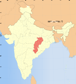 | |
|---|---|---|
| Topics | ||
| Districts | ||
| Cities | ||
| ||