Chandrapur
| Chandrapur | |
|---|---|
| City | |
| Nickname(s): City of Black Gold | |
 Chandrapur Location in Maharashtra, India | |
| Coordinates: 19°57′00″N 79°17′49″E / 19.950°N 79.297°ECoordinates: 19°57′00″N 79°17′49″E / 19.950°N 79.297°E | |
| Country |
|
| State | Maharashtra |
| District | Chandrapur |
| Named for | Chandrapur Fort |
| Government | |
| • Type | Municipal Corporation |
| • Body | Chandrapur Municipal Corporation |
| • Mayor | Anjali Ghotekar |
| • Municipal Commissioner | Sanjay Kakade |
| • Additional Municipal Commissioner | Bhalchandra Behere |
| Area | |
| • Total | 56.40 km2 (21.78 sq mi) |
| Elevation | 188 m (617 ft) |
| Population (2011) | |
| • Total | 320,379 |
| Demonym(s) | Chandrapurkar |
| Language | |
| • Official | Marathi |
| Time zone | UTC+5:30 (IST) |
| PIN | 442401,442402,442403,442404 |
| Telephone code | (+91), 7172 |
| Vehicle registration | MH 34 |
| Website | Official website |
Chandrapur is a municipal corporation in Chandrapur district, Maharashtra state, India. It is the centre of governance of Chandrapur district. Chandrapur was a fort city founded by Khandakya Ballal Sah, a Gond king of the 13th century[1] The city is situated at the confluence of the Irai and Zarpat rivers. The area around the city is rich in coal seams. Hence, Chandrapur is known as "black gold city".
Etymology
The local people relate the name "Chandrapur" to the words Chandra (the moon) and pur (a settlement) after a legend. Scholars see the name as a derivative of "Indupur" (city of the moon) which stood near the Jharpat in the Treta Yuga. Chandrapur is nicknamed the "black gold city" after nearby coal mining.
History
Archeological finds such as signs of pottery making, suggest inhabitation of the Chandrapur area in Neolithic times.[2]
From ancient times, Chandrapur has fallen under the control of many different rulers. Between 322 BCE and 187 BCE, much of India, including Maharashtra, was part of the Maurya Empire.[3] From 187 BCE to 78 BCE, Chandrapur was part of the Shunga Empire which controlled much of central and eastern India.[4] The Satavahana Empire controlled Chandrapur from the 1st century BCE to the 2nd century CE.[5] The Vakataka dynasty ruled from the area from the mid 3rd century CE to 550 CE.[6] The Kalachuri dynasty ruled in the area in the 6th and 7th centuries CE.[7] The Rashtrakuta dynasty followed, controlling the Chandrapur region between the 7th and 10th centuries. The Chalukya dynasty ruled in the region to the 12th century CE.[8] The Seuna (Yadava) dynasty of Devagiri ruled a kingdom, including the Chandrapur area, in approximately 850 CE and continued until 1334 CE.[9]
The Gond people are part of the Adivasi (indigenous people) of India. In ancient times, the Gond diaspora spread throughout central India. After the passage many kings, who were largely subservient to other rulers, Khandkya Ballal (1470 – 1495) came to the throne. He founded Chandrapur and died there.[10] Gond rule was lost in 1751 to the Maratha period. The last ruler of the Maratha dynasty, Raghuji Bhonsle III died in 1853 without issue.
The Gond king, Khandkya, who founded Chandrapur, was covered in tumours. His wise and beautiful wife nursed him. She asked him to leave Sirpur and move to the north bank of the Wardha River. There, the king built a fort he named "Ballalpur". One day, while hunting north-west of Ballalpur, the king became thirsty and rode up to the dry bed of the Jharpat river in search of water. He discovered water trickling from a hole, and after drinking, washed his face, hands and feet. That night he slept soundly for the first time in his life.
On his return the queen was delighted to see that many of the tumours on her husband's body had disappeared. The king said it was the water that had cured him and took his wife to see the water hole. On clearing the grass and sand, they found five footprints of a cow in the solid rock, each filled with water. The water source at the spot was inexhaustible and considered holy. The place was called "Tirtha of Acalesvar of the Treta Yuga". When the king bathed in the water all the tumours on his body vanished. That night at the water hole, Acalesvar appeared to the king in a dream, and spoke comforting words. A temple was built over the water hole.
One morning, at the water hole, the king saw a hare darting out of a bush and chasing his dog. Eventually, the dog killed the hare. The king found a white spot on the forehead of the hare. The queen said it was a good omen and a fortified city should he built with its layout based on the chase of the dog and hare. She said the place where the hare was killed would be unlucky for the city. The king's officers, the "Tel Thakurs" built the fortified city. The city became Chandrapur.
In 1853, Chandrapur was annexed to British India. During the British colonial period the area of Chandrapur was called "Chanda district". By 1871, Anglican and Scottish Episcopal missionaries had arrived in the city.[11]
In 1874, three tehsils were created: Viz Mul, Warora and Bramhpuri. The upper Godavai district of Madras was abolished and four tehsils were added to Chandrapur to form one tehsil with Sironcha, approximately 150 km to the south, as its centre of governance. In 1895, the headquarters was transferred to Chandrapur. In 1905, a new tehsil with headquarters at Gadchiroli was created through the transfer of zamindari estates from Bramhpuri and Chandrapur tehsil. In 1907, a small area of land was transferred from Chandrapur to the newer districts and another area of about 1560 km2, comprising three divisions of the lower Sironcha tehsil (Cherla, Albak and Nugir) were transferred to Madras State. Between 1911 and 1955, no major changes occurred in the boundaries of the district or its tehsils.
In 1956, with the reorganization of Indian states, Chandrapur district was transferred from Madhya Pradesh to Bombay state. In 1959, part of Adilabad district of Hyderabad state, was transferred to Chandrapur district. In May 1960, Chandrapur district became part of the Maharashtra state. Following the 1981 Census of India, Chandrapur district was divided into Chandrapur district and Gadchiroli district. This was for administrative convenience and industrial and agricultural development.
Geography
Chandrapur is located in central India in the eastern part of Maharashtra state at 19.57°N latitude and 79.18°E longitude. The nearest major city is Nagpur, 100 kilometres (62 mi) to the north. To the east is Gadchiroli district including the Gadchiroli forest reserve and the Sundarnagar range. To the south is the Wardha River with villages scattered along its banks. To the west of Chandrapur lies the Painganga river and the Maharashtra State Highway 6. Chandrapur is situated at 189.90 meters above the mean sea level.
Chandrapur lies at the confluence of the Erai and Zarpat rivers. The Erai river has a history of flooding. Flood marks are seen on the walls of the city. In the north of the city, a dam is constructed on the river Erai, having the capacity of 207 million cubic meters. The Gaontideo Nala originates from the uplands of the Chandrapur Super Thermal Power Station. The Macchhi Nala originates from uplands of Central Forest Rangers College.
Chandrapur lies on terrain rich in coal. Chandrapur is called a "geological museum" as there is a large variety of rocks as well as commercially valuable minerals and fossils. Samples of such rocks are collected at the Suresh Chopane Rock Museum.[12]
The area of the city is about 70.02 km². The north-south length of the city is about 10.6 km, while the east-west length is about 7.6 km. The city slopes from the north to the south. The old city is surrounded by walls called parkots. The walls have four gates: Jatpura Gate, Anchaleshwar Gate, Pathanpura Gate and Binba Gate. There are also four khidki (windows): Bagad Khidki, Hanuman Khidki, Vithoba Khidki and Chor Khidki.
Climate
Chandrapur has a hot and dry climate. December is the coldest month, with a minimum average temperature of 9 °C and a maximum average temperature of 23.2 °C. May is the hottest month with a mean maximum temperature of 43 °C and a mean minimum temperature of 28.2 °C. On 2 June 2007, there was a highest recorded temperature of 49 °C. On January 1899, there was a lowest recorded temperature of 2.8 °C.
The monsoon season comes between June and September. Chandrapur's average annual rainfall is 1249.4 mm. The average number of rainy days is 59.2.[13]
| Climate data for Chandrapur (1971–2000) | |||||||||||||
|---|---|---|---|---|---|---|---|---|---|---|---|---|---|
| Month | Jan | Feb | Mar | Apr | May | Jun | Jul | Aug | Sep | Oct | Nov | Dec | Year |
| Record high °C (°F) | 35.8 (96.4) |
40.0 (104) |
44.4 (111.9) |
46.4 (115.5) |
48.6 (119.5) |
49.0 (120.2) |
40.6 (105.1) |
37.2 (99) |
38.4 (101.1) |
40.1 (104.2) |
36.1 (97) |
38.7 (101.7) |
49.0 (120.2) |
| Average high °C (°F) | 30.3 (86.5) |
33.1 (91.6) |
37.7 (99.9) |
41.5 (106.7) |
43.0 (109.4) |
37.8 (100) |
32.0 (89.6) |
30.8 (87.4) |
32.4 (90.3) |
32.9 (91.2) |
31.0 (87.8) |
29.6 (85.3) |
34.3 (93.7) |
| Average low °C (°F) | 14.5 (58.1) |
16.9 (62.4) |
21.0 (69.8) |
25.4 (77.7) |
28.2 (82.8) |
26.7 (80.1) |
24.4 (75.9) |
24.0 (75.2) |
23.8 (74.8) |
21.4 (70.5) |
16.9 (62.4) |
13.2 (55.8) |
21.3 (70.3) |
| Record low °C (°F) | 2.8 (37) |
3.9 (39) |
7.2 (45) |
11.7 (53.1) |
18.9 (66) |
20.0 (68) |
17.8 (64) |
18.3 (64.9) |
18.3 (64.9) |
10.9 (51.6) |
6.2 (43.2) |
3.5 (38.3) |
2.8 (37) |
| Average rainfall mm (inches) | 12.7 (0.5) |
16.4 (0.646) |
12.6 (0.496) |
14.7 (0.579) |
16.8 (0.661) |
181.2 (7.134) |
361.9 (14.248) |
356.9 (14.051) |
178.3 (7.02) |
77.6 (3.055) |
13.9 (0.547) |
6.5 (0.256) |
1,249.4 (49.189) |
| Average precipitation days | 0.8 | 1.0 | 1.0 | 1.4 | 1.5 | 8.9 | 15.2 | 15.0 | 9.0 | 3.8 | 1.0 | 0.6 | 59.2 |
| Source: India Meteorological Department[14][13] | |||||||||||||
Demographics
Per the 2011 census of India, Chandrapur's population was 375,000. On 20 October 2011, Chandrapur municipal council was elevated to a D-grade municipal corporation.[15][16]
Languages
Marathi is spoken by majority of the people in Chandrapur. The native Gondi is spoken by most of the Gonds in Chandrapur. Telugu is also spoken widely by Telugu people in Chandrapur. People are also fluent in Hindi. A large section of population also speaks English.
Akhil Bharatiya Marathi Sahitya Sammelan, the conference on Marathi literature, has been held twice in Chandrapur, in 1979 (Chair Vaman Krushna Chorghade) and in 2012 (Chair Vasant Aabaji Dahake).[17]
In 2016, the inaugural All India Gondi Religious Convention was convened by the Central Provinces and Berar Gondwana Samaj Sewa Samiti in Warora, 30 km north west of Chandrapur. The chair was Birshah Krushnashah Atram, a descendant of Khandkya Ballal Sah.
Religion
71.84 percent of people in Chandrapur are Hindu. 15.64 percent are Buddhist. 10.07 percent are Muslims; 0.94 percent are Christians; 0.54 percent follow Jainism; and 0.44 percent are Sikhs. 0.47 percent follow other religions and 0.05 percent identify with no particular religion.[18]
- Mahakali mandir
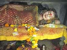
Mahakali mandir (temple) is an often frequented temple in Chandrapur. Tuesdays are a particularly significant day to visit. Within the mandir there is a small Ganesh temple and a Hanuman temple. At the two temple entrances, there are small shops for puja (worship) supplies such as coconut, flowers and cloth. Items for home décor and puja décor are sold near the temple. Near the rear entrance there is a Shani temple.
Within the mandir are two murtis (idols). One associated with Shiv Ling is a standing idol decorated with red, yellow and orange cloths. The other is in a reclining position below the ground level, and devotees must walk in a tunnel to reach it. Inside the temple, a priest is present to assist visitors with puja and offerings. A trust administers the temple. Dharmashalas provide accommodation for pilgrims. The annual yatra (fair) takes place in April, entertaining the followers of Mahakali and the citizens of Chandrapur.
- Anchaleshwar mandir
The Anchaleshwar mandir celebrates a form of the Lord Siva. It is situated near the Anchaleshwar Gate on the banks of the Zarpat river. The official samadhi (mausoleum) of the Gond kings is located within the temple complex.
- Deeksha Bhoomi
On 16 October 1956, B. R. Ambedkar (Babasaheb) gave the deeksha (the embracing of Buddhism) to many followers at a place near Chandrapur since known as Deekshabhoomi. Ambedkar chose only Nagpur and Chandrapur for the conversion of the people to Buddhism. Rajabhau Khobragade, a barrister established the Dr. Babasaheb Ambedkar College of Arts, Commerce and Science on the Deeksha Bhoomi premises. A transplanted branch of the Bodhi Tree (a sacred fig from Bodh Gaya) is growing at the Deekshabhoomi. On 15 and 16 October, there is an annual pilgrimage of followers and monks to Deekshabhoomi for the Dhamma Chakra Pravartan Din.
Transport
Chandrapur lies on major state highways MH MSH 6, MH MSH 9 and state highways MH SH 233, MH SH 243 and MH SH 264. Chandrapur is connected to many cities in Maharashtra by the Maharashtra State Road Transport Corporation bus service.
Chandrapur railway station is managed by the Nagpur CR railway division of the Central Railway. Chandrapur lies on the New Delhi to Chennai line. The Chanda Fort railway station is managed by the Nagpur SEC railway division. It lies on the Bangalore to Gorakhpur line.
Chandrapur Airport, operated by the Maharashtra Airport Development Company, is situated near Morwa village on MH SH 264, about 12 km from the city. The airstrip is 950 m in length. Development of the airport is limited by surrounding obstructions, particularly the thermal power plant.[19] The nearest airport with scheduled flights is the Dr. Babasaheb Ambedkar International Airport in Nagpur.
Industries
Chandrapur is a centre for coal mining. In 2012, there were 27 coal mines around Chandrapur.[20]
Other industries include cement making, paper manufacturing, and ferro alloy manufacturing.
Chandrapur Super Thermal Power Station
The Chandrapur Super Thermal Power Station, a 3,340 MW power station complex which is owned by the Maharashtra State Power Generation Company Limited, occupies an area of 12,212 hectares (122.12 km2) about 6 kilometres (3.7 mi) from the city. It employs approximately 3,460 people and supplies more than 25 percent of the state's electricity. A masonry dam on the Erai river, 15 km from the station provide water to the station and to Chandrapur. On 16 January 1977, the station's foundation stone was laid by the Central Energy Minister, K. C. Pant.
Education
The Karmavir Dadasaheb Kannamwar High School (previously known as the Zilha Parishad Jubilee High School) was established in 1906. The Lokmanya Tilak Vidyalaya was founded in 1932 by Bal Gangadhar Tilak. The Chanda Sikshan Prasarak Mandal is a large educational institution with a number of campuses in Chandrapur.
Chandrapur has a government medical college and a government engineering college. The city's colleges (apart from the medical school) are affiliated with Gondwana University.
Tadoba National Tiger Reserve
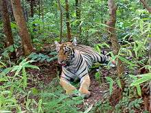
The Tadoba Andhari Tiger Reserve is located approximately 30 km north of Chandrapur near the Erai dam.
Notable people
- Karmavir Dadasaheb Kannamwar, second Chief Minister of Maharashtra.
- Mohan Bhagwat, chief of the Rashtriya Swayamsewak Sangh.
- Balasaheb Deshmukh, follower of Bal Gangadhar Tilak. It was due to his efforts that Tilak visited Chandrapur and laid foundation of Lokmanya Tilak Vidyalaya.
- Abdul Shafee, politician of the Indian National Congress Party, Member of Parliament 5th Loksabha, MLC.
- Barrister Rajabhau Khobragade, Deputy Chairman of Rajya Sabha, leader of the Republican Party of India (Khobragade) and follower of B. R. Ambedkar.
- Shantaram Potdukhe, former Minister of Finance.
See also
References
- ↑ Deogaonkar, Shashishekhar. The Gonds of Vidarbha. Concept Publishing Company, 2007. p. 37. ISBN 978-8180694745.
- ↑ Miksic, John (2003). Earthenware in Southeast Asia: Proceedings of the Singapore Symposium. NUS Press. ISBN 9971692716.
- ↑ Meyer, William (1966). Chandragupta Maurya and his times. Motilal Banarsidass. ISBN 9788120804050.
- ↑ Thapar, Romila (2004). Early India. Los Angeles: University of California press. p. 2010. ISBN 9780520242258.
- ↑ Dutt, Sukumar (1988). Buddhist Monks and Monasteries. Motilal Banarsidass. p. 123. ISBN 9788120804982.
- ↑ Majumdar R.C. Vakataka - Gupta Age Circa 200-550 A.D. Motilal Banarsidass 1986. p. 123
- ↑ Mirashi, V. V.; Navlekar, N. R. Kalidasa: Date, Life And Works. Popular Prakashan. p. 22. ISBN 9788171544684.
- ↑ Ramesh, K. V. (1984). Chalukyas of Vatapi. Agam Kala Prakashan.
|access-date=requires|url=(help) - ↑ Sen, S. N. (1999). Ancient Indian History and Civilisation. New Age International. p. 403. ISBN 9788122411980.
- ↑ "Kingdoms of South Asia". The History Files. Retrieved 12 December 2017.
- ↑ Strong, Rowan (2002). Episcopalianism in Nineteenth-Century Scotland. Oxford: Oxford University Press. p. 31. ISBN 9780199249220.
- ↑ Hussain. Geography of India for Civil Ser Exam. Tata McGraw-Hill Education. ISBN 9780070667723.
- 1 2 "Ever Recorded Maximum Temperature, Minimum Temperature and 24 Hours Heaviest Rainfall upto 2010" (PDF). India Meteorological Department. Archived from the original on 2013-05-21. Retrieved 2013-05-21.
- ↑ "Monthly mean maximum & minimum temperature and total rainfall based upon 1971–2000 data". India Meteorological Department. Retrieved 2013-05-21.
- ↑ Chandrapur is now municipal corporation with the population of 3.73 Lakh - TOI NEWS Article, 21 October 2011
- ↑ EC to declare reservation of CMC wards - TOI NEWS Article, 26 Jan 2012
- ↑ Marathi literary congregation concludes in Chandrapur.
- ↑ Chandrapur Religion 2011
- ↑ "MADC projects". Archived from the original on 26 February 2012. Retrieved 24 April 2012.
- ↑ Hiro, Dilip (2015). The Age of Aspiration: Power, Wealth, and Conflict in Globalizing India. New Press. p. 182. ISBN 9781620971413.
External links
| Wikivoyage has a travel guide for Chandrapur. |
Chandrapur district topics | ||
|---|---|---|
| History | 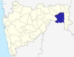 | |
| Geography | ||
| Cities and towns | ||
| Lok Sabha constituencies | ||
| Vidhan Sabha constituencies | ||
| Districts of Vidarbha | |
|---|---|
| Cities with municipal corporations | |
Portal: Maharashtra | |
| Topics | |||||||||||||
|---|---|---|---|---|---|---|---|---|---|---|---|---|---|
| Regions | |||||||||||||
| Divisions and Districts |
| ||||||||||||
| Million-plus cities in Maharashtra | |||||||||||||
| Other cities with municipal corporations | |||||||||||||
Portal: Maharashtra | |||||||||||||