Udham Singh Nagar district
| Udham Singh Nagar district | |
|---|---|
| District | |
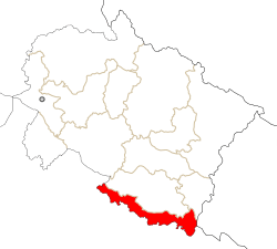 Location in Uttarakhand, India | |
| Coordinates: 28°59′N 79°24′E / 28.98°N 79.40°ECoordinates: 28°59′N 79°24′E / 28.98°N 79.40°E | |
| Country |
|
| State | Uttarakhand |
| Division | Kumaon |
| Headquarters | Rudrapur |
| Area | |
| • Total | 2,908 km2 (1,123 sq mi) |
| Population | |
| • Total | 1,235,614 |
| • Density | 425/km2 (1,100/sq mi) |
| Languages | |
| • Official | Hindi, Punjabi |
| Time zone | UTC+5:30 (IST) |
| Vehicle registration | UK 06, UK 18 |
| Website |
usnagar |
Udham Singh Nagar District is a district of Uttarakhand state in northern India. Rudrapur is the district headquarters. This district consists of seven Tehsils named Bajpur, Gadarpur, Jaspur, Kashipur, Kichha, Khatima, Sitarganj. The district is located in the Terai region, and is part of Kumaon Division. It is bounded on the north by Nainital District, on the northeast by Champawat District, on the east by Nepal, and on the south and west by Bareilly, Rampur, Moradabad, Pilibhit and Bijnor District of Uttar Pradesh state. The district was created in October 1995 by Mayawati government out of Nainital District. It is named for freedom fighter and Indian revolutionary Shaheed-i-Azam Sardar Udham Singh.[1]
As of 2011 it is the third most populous district of Uttarakhand (out of 13), after Haridwar and Dehradun.[2]
G.B. Pant University, noted for its engineers & agriculture scientists, is located 5 km from Rudrapur.
Tehsils in Udham Singh Nagar district
Cities in Udham Singh Nagar district
Demographics
According to the 2011 census Udham Singh Nagar district has a population of 1,648,367,[2] roughly equal to the nation of Guinea-Bissau[3] or the US state of Idaho.[4] This gives it a ranking of 303rd in India (out of a total of 640).[2] The district has a population density of 648 inhabitants per square kilometre (1,680/sq mi) .[2] Its population growth rate over the decade 2001-2011 was 33.4%.[2] Udham Singh Nagar has a sex ratio of 919 females for every 1000 males,[2] and a literacy rate of 74.44%.[2]
Languages[5]
Major languages spoken in Udham Singh nagar are following => Hindi 72.18% (including Kumaoni - 5.22%, bhojpuri - 3.65%, garhwali 0.35%), Urdu 6.38% Punjabi 10.09%, Bengali 7.86%, Tharu (under Maithili language) 2.88%
References
- ↑ Singh, Anand Raj (12 March 2015). "Mayawati may create new district to tame old foe". The New Indian Express. Retrieved 14 May 2016.
- 1 2 3 4 5 6 7 "District Census 2011". Census2011.co.in. 2011. Retrieved 2011-09-30.
- ↑ US Directorate of Intelligence. "Country Comparison:Population". Retrieved 2011-10-01.
Guinea-Bissau 1,596,677 July 2011 est.
- ↑ "2010 Resident Population Data". U. S. Census Bureau. Retrieved 2011-09-30.
Idaho 1,567,582
- ↑ "Census of India Website : Office of the Registrar General & Census Commissioner, India". www.censusindia.gov.in. Retrieved 2018-08-28. line feed character in
|title=at position 81 (help)
External links
Places adjacent to Udham Singh Nagar district | ||||||||||
|---|---|---|---|---|---|---|---|---|---|---|
| ||||||||||