Khandesh
| Khandesh | |
|---|---|
| Historical region | |
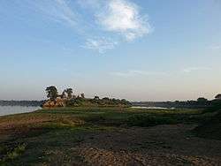 Landscape of the Tapi River in Dhule district. | |
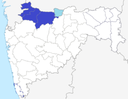 Blue: Khandesh in Maharashtra Light Blue: Khandesh in Madhya Pradesh (Burhanpur) | |
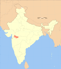
| Country | India |
| State | Maharashtra and Madhya Pradesh |
| Elevation | 240 m (790 ft) |
| Demonym(s) | Khandeshi |
Khandesh (Marathi:खानदेश) is a geographic region in Central India, which forms the northwestern portion of Maharashtra state.[1]
History
In 1295, Khandesh was under the Chauhan ruler of Asirgarh when Ala-ud-din Khilji of Delhi wrested control.[2]:418 Various Delhi dynasties controlled Khandesh over the next century.[2]:418 From 1370 to 1600, the Faruqi dynasty with the capital at Burhanpur, who maintained their independence from the Bahmani, ruled Khandesh.[2]:418The foundation of Khandesh as an independent kingdom was laid by Malik Raja, son of Khanjahan Faurki. Initially Firuz Shah Tughlaq had appointed Malik Raja as tha commander-in-chief of Khandesh region. After the death of Firoz Tughlaq, Malik Raja declared himself independent and ruled till 1399.[3]
Mughal rule
The Mughals arrived in 1599, when Akbar's army overran Khandesh and captured Asirgarh.[2]:418 For a period of time, Khandesh was renamed as Dandesh in recognition of Akbar's son Daniyal.[4]:248 About 1640, Todar Mal's revenue settlement system was introduced in Khandesh by Shah Jahan, a system that was to continue until the introduction of British rule in 1818.[4]:250 The middle of the 17th century has been described as the time of Khandesh's "highest prosperity" owing to cotton, rice, indigo, sugarcane, and the cloth trade.[4]:250 Mughal rule lasted until the Marathas captured Asirgarh in 1760.[2]:418
Maratha rule
Maratha raids into Khandesh commenced in 1670 and the following century was a period of unrest as Mughals and Marathas competed for control.[2]:418 In 1760, the Peshwa ousted the Mughal ruler and gained control of Khandesh, following which portions were granted to Holkar and Scindia rulers.[2]:418 Baji Rao II surrendered to the British in June 1818, but sporadic war continued in Khandesh and was among the last of the Peshwa's former territories to come under complete British control.[5]:9
British rule
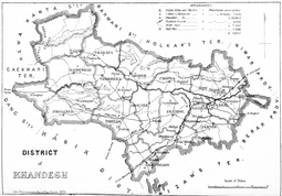
Up to 1906, Khandesh was a district in the Bombay Presidency.[6] In that year, the district was divided into two districts: East Khandesh, headquartered at Jalgaon, had an area of 4544 mi² and a population of 957,728 in 1901, while West Khandesh, headquartered at Dhule had an area of 5497 mi² and a population of 469,654 in 1901.[7]
Independent India
After India's independence in 1947, Bombay province became Bombay state, which was divided into the linguistic states of Maharashtra and Gujarat in 1960. During the formation of the State of India, Burhanpur became the part of the state of Madhya Pradesh. In 1960, East Khandesh became Jalgaon district, and West Khandesh became Dhulia district (present-day Dhule) of Maharashtra.[8] The latter was further divided into Dhule and Nandurbar districts.[9]
Culture
Khandesh has a rich cultural and literary heritage.
Languages
Marathi is the official and most-spoken language in Khandesh. Ahirani and Gurjar are spoken in West Khandesh from Girana basin; this language is a dialect of Marathi with some Gujarati and Hindi influence. Khandeshi is spoken in the eastern part of Khandesh.[10] Dakhini is also spoken here.
Arts
Mukta Bai, the younger sister of Dnyaneshwar, lived at Muktainagar, near where the great yogi Changdeva lived in the thirteenth century. There was also a strong presence of Kabir Panth in Khandesh due to the proximity of Burhanpur, the seat of Kabir Panth.
Bahinabai Chaudhari, regarded as one of the greatest poetesses in Marathi literature, belonged to a Khandeshi farmer family. Her son, Kavi Sopandeo Choudhary, was famous for his poetry with a touch of humor.Trambak Bapuji Thombre,commonly known as Balkavi is from Jalgaon. Dr. V.B. Kolte, a noted scholar of Marathi, hailed from Khandesh; he was the top authority on Mahanubhav literature.
Well known Marathi writers from Khandesh region, include Dr. Bhalchandra Nemade, N. D. Mahanor, and Dr. Sharad Rane. Dr. Nemade is known for his novels Kosala, Bidhar, Jarila and Zool, and collection of poetry Melody. His recent addition is Hindu.
Geography
Khandesh lies on the northwestern corner of the Deccan plateau, in the valley of the Tapi River, and is bounded to the north by the Satpura Range, to the east by the Berar (Vidarbha) region, to the south by the Hills of Ajanta, belonging to the Marathwada region of Maharashtra, and to the west by the northernmost ranges of the Western Ghats, and beyond them the coastal plain of Gujarat.
The principal natural feature is the Tapi River.[9] Unlike the rest of the Deccan, whose rivers rise in the Western Ghats and flow eastward to the Bay of Bengal, the Tapi flows westward from headwaters in southern Madhya Pradesh to empty into the Arabian Sea. The Tapi receives thirteen principal tributaries in its course through Khandesh. None of the rivers is navigable, and the Tapi flows in a deep bed which historically made it difficult to use for irrigation. Most of Khandesh lies south of the Tapi and is drained by its tributaries the Girna, Bori and Panjhra. The alluvial plain north of the Tapi contains some of the richest tracts in Khandesh, and the land rises towards the Satpuda hills. In the centre and east, the country is level, save for some low ranges of barren hills. To the north and west, the plain rises into rugged hills, thickly wooded, and inhabited by the tribal Bhil people.
| Geographic Elements | |||||||||
|---|---|---|---|---|---|---|---|---|---|
Geographic ElementsCities
Rivers
Dams
|
See also
References
- ↑ "Welcome to Khandesh!". Khandesh.com. Retrieved 2010-08-01.
- 1 2 3 4 5 6 7 Imperial Gazetteer of India. Provincial Series: Bombay Presidency Vol. 1. Calcutta: Superintendent of Government Printing. 1909.
- ↑ Goyal, S. P. Historical Atlas. Agra: Upkar. p. 68. ISBN 978-81-7482-752-4.
- 1 2 3 Gazetteer of the Bombay Presidency. Volume XII: Khandesh. Bombay: Government Central Press. 1880.
- ↑ Deshpande, Arvind M. (1987). John Briggs in Maharashtra: A Study of District Administration Under Early British Rule. Delhi: Mittal Publications.
- ↑ Census of India, 1911 (PDF). Volume VII, Bombay: Part 1, Report. Bombay: Government Central Press. 1912. p. 1.
- ↑ "Khandesh". Khandesh. Retrieved 2010-08-01.
- ↑ Jamkar, A.G. (1988). "Origin and Evolution of Periodic Market Places in Dhule District (Maharashtra)". In Shrivastava, V.K. Commercial Activities and Rural Development in South Asia: A Geographical Study. New Delhi: Concept Publishing Company. p. 134. ISBN 81-7022-194-3.
- 1 2 Patil, M.V. (2015). An Inventory on Agrobiodiversity and Homestead Gardens in Tribal Tehsils of Khandesh Maharashtra. North Maharashtra University. pp. Chapter 6-1.
- ↑ Santronix Computers pvt. Ltd. (2007-05-19). "Khandesh cultural heritage - Jalgaon, Dhule, Nandurbar lifestyle". Ejalgaon.com. Archived from the original on 20 August 2010. Retrieved 2010-08-01.
External links
Coordinates: 21°N 75°E / 21°N 75°E
| Topics | |||||||||||||
|---|---|---|---|---|---|---|---|---|---|---|---|---|---|
| Regions | |||||||||||||
| Divisions and Districts |
| ||||||||||||
| Million-plus cities in Maharashtra | |||||||||||||
| Other cities with municipal corporations | |||||||||||||
Portal: Maharashtra | |||||||||||||