Sahebganj district
| Sahibganj district | |
|---|---|
| District of Jharkhand | |
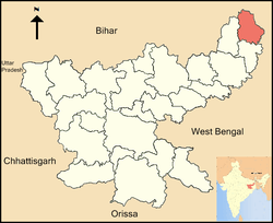 Location of Sahibganj district in Jharkhand | |
| Country | India |
| State | Jharkhand |
| Administrative division | Santhal Pargana Division |
| Government | |
| • Lok Sabha constituencies | Rajmahal |
| • Assembly seats | 3 |
| Area | |
| • Total | 1,599 km2 (617 sq mi) |
| Population (2011) | |
| • Total | 1,150,038 |
| • Density | 720/km2 (1,900/sq mi) |
| Demographics | |
| • Literacy | 53.73 per cent[1] |
| • Sex ratio | 948 |
| Website | Official website |
Sahibganj district is one of the twenty-four districts of Jharkhand state, India, and Sahibganj is the administrative headquarters of this district.
Divisions
Sahibganj district is divided into two subdivions: Sahibganj subdivision and Rajmahal subdivision. It is further subdivided into nine Community development blocks:(Sahibganj subdivision) Sahibganj, Mandro, Borio, Barhait (Rajmahal subdivision) Taljhari, Rajmahal, Udhwa, Pathna and Barharwa.[2]
Economy
In 2006 the Ministry of Panchayati Raj named Sahibganj one of the country's 250 most backward districts (out of a total of 640).[3] It is one of the 24 districts in Jharkhand currently receiving funds from the Backward Regions Grant Fund Programme (BRGF).[3]
Demographics
According to the 2011 census Sahibganj district has a population of 1,150,038,[4] roughly equal to the nation of Timor-Leste[5] or the US state of Rhode Island.[6] This gives it a ranking of 407th in India (out of a total of 640).[4] The district has a population density of 719 inhabitants per square kilometre (1,860/sq mi).[4] Its population growth rate over the decade 2001-2011 was 23.96%.[4] Sahibganj has a sex ratio of 948 females for every 1000 males,[4] and a literacy rate of 53.73%.[4]
See also
References
- ↑ "District-specific Literates and Literacy Rates, 2011". Registrar General, India, Ministry of Home Affairs. Retrieved 2011-12-11.
- ↑ "District Profile". Census 2011. Sahibganj district administration. Archived from the original on 4 March 2016. Retrieved 12 January 2016.
- 1 2 Ministry of Panchayati Raj (September 8, 2009). "A Note on the Backward Regions Grant Fund Programme" (PDF). National Institute of Rural Development. Archived from the original (PDF) on April 5, 2012. Retrieved September 27, 2011.
- 1 2 3 4 5 6 "District Census 2011". Census2011.co.in. 2011. Retrieved 2011-09-30.
- ↑ US Directorate of Intelligence. "Country Comparison:Population". Retrieved 2011-10-01.
Timor-Leste 1,177,834 July 2011 est.
- ↑ "2010 Resident Population Data". U. S. Census Bureau. Retrieved 2011-09-30.
Rhode Island 1,052,567
External links
Places adjacent to Sahebganj district | ||||||||||
|---|---|---|---|---|---|---|---|---|---|---|
| ||||||||||