Indian road network
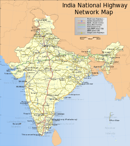
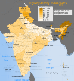
India has a road network of over 5,603,293 kilometres (3,481,725 mi) as on 31 March 2016, the second largest road network in the world.[1] At 1.70 km of roads per square kilometre of land, the quantitative density of India's road network is higher than that of Japan (0.91) and the United States (0.67), and far higher than that of China (0.46), Brazil (0.18) or Russia (0.08).[1] Adjusted for its large population, India has approximately 4.63 km of roads per 1000 people. However, qualitatively India's roads are a mix of modern highways and narrow, unpaved roads, and are being improved.[2] As on 31 March 2016, 62.5% of Indian roads were paved.[1]
India in its past did not allocate enough resources to build or maintain its road network.[2] This has changed since 1995, with major efforts currently underway to modernize the country's road infrastructure.[3] The length of national highways in India has increased from 70,934 km in 2010-11 to 101,011 km in 2015-16.[1]


As of May 2017, India had completed and placed in use over 28,900 kilometres of recently built 4 or 6-lane highways connecting many of its major manufacturing centres, commercial and cultural centres.[4] According to Ministry of Road Transport and Highways, as of March 2016, India had about 1,01,011 kilometers of national highways and expressways, plus another 1,76,166 kilometers of state highways.[1] Major projects are being implemented under the National Highways Development Project, a government initiative. Private builders and highway operators are also implementing major projects - for example, the Yamuna Expressway between Delhi and Agra was completed ahead of schedule and within budget,[5] while the KMP Expressway started in 2006 is far behind schedule, over budget and incomplete.[6]
According to 2009 estimates by Goldman Sachs, India will need to invest US$1.7 trillion on infrastructure projects before 2020 to meet its economic needs, a part of which would be in upgrading India's road network.[7] The investment in national highways increased from ₹14,095.87 crore (US$2.0 billion) in 2005-06 to ₹98,988.06 crore (US$14 billion) in 2015-16.[1] During the same period the total investment in national highways was ₹476,589.37 crore (US$66 billion). The Government of India is attempting to promote foreign investment in road projects.[7][8][9] Foreign participation in Indian road network construction has attracted 45 international contractors and 40 design/engineering consultants, with Malaysia, South Korea, United Kingdom and United States being the largest players.[10]
History
The first evidence of road development in the Indian subcontinent can be traced back to approximately 2800 BC from the ancient cities of Harrapa and Mohenjodaro of the Indus Valley Civilization. Ruling emperors and monarchs of ancient India had constructed roads to connect the cities. Archaeological excavations give us fresh information about road connectivity in ancient India. The Grand Trunk Road was built by Sher Shah Suri in 1540-45 connecting Sonargaon near Dhaka in Bangladesh with Peshawar in modern-day Pakistan linking several cities from in India.[13]
In the 1830s the East India Company started a programme of metalled road construction, for both commercial and administrative purposes. The Grand trunk road, from Calcutta, through Delhi to Peshawar was rebuilt at a cost of £1000 / mile, roads from Bombay to Pune Camp, Bombay to Agra, and Bombay to Madras, were constructed, and a Public Works Department, and the Indian Institute of Technology Roorkee founded, to train and employ local surveyors, engineers, and overseers, to perform the work, and maintain the roads. The programme resulted in an estimated 2,500 km (1,600 miles) of metalled roads being constructed by the 1850s[14][15]
In December 1934 the Indian Road Congress (IRC) was formed, on the recommendations of the Indian Road Development Committee (Jayakar Committee) of the Government of India. They proposed a twenty-year plan, in 1943, to increase the road network from 350,000 km (220,000 miles), to 532,700 km (331,000 miles) by 1963, to achieve a road density of 16 km, per 100 km2 of land. The construction was to be paid in part through the duty imposed, since 1939, on petrol sales, and became known as the Nagpur Plan. The construction target was achieved in the late 1950s.[16]
In 1956 a Highways Act was passed, and a second twenty-year plan proposed for the period 1961-1981, with the ambition of doubling road density to 32 km, per 100 km2. This second plan became known as the Bombay Road Plan.[16]
India inherited a poor road network infrastructure at the time of its independence in 1947. Beyond that, between 1947 and 1988, India witnessed no new major projects, and the roads were poorly maintained. Predominantly all roads were single lane, and most were unpaved. India had no expressways, and less than 200 kilometers of 4-lane highways.
In 1988, an autonomous entity called the National Highways Authority of India was established in India by an Act of Parliament, and came into existence on 15 June 1989. The Act empowered this entity to develop, maintain and manage India's road network through National Highways. However, even though the Authority was created in 1988, not much happened till India introduced widespread economic liberalization in the early 1990s. Since 1995, the authority has privatized road network development in India.
One of the most ambitious projects to improve roads in India was under the National Highways Development Project (NHDP) started in the year 1998 by then Prime Minister Atal Bihari Vajpayee. The flagship project of the NHDP is the Golden Quadrilateral, a total of 5,846 km long 4/6 laned highways connecting the four major cities of Delhi, Mumbai, Chennai and Kolkata. Total cost of the project is Rs.300 billion (US$6.8 billion), funded largely by the government’s special petroleum product tax revenues and government borrowing. In January 2012, India announced the four-lane GQ highway network as complete.[17][18]
Another important road project is the 7,142 km long 4/6 laned North–South and East–West Corridor comprising national highways connecting four extreme points of the country. The North–South and East–West Corridor connects Srinagar in the north to Kanyakumari in the south, including spur from Salem to Kanyakumari (via Coimbatore and Kochi) and Silchar in the east to Porbandar in the west. As of 31 October 2016, 90.99% of the project had been completed, 5.47% of the project work is under Implementation and 3.52% of the total length is left.[19] As of May 2017, under NHDP about 28,915 kilometers of 4/6 lane highways has been constructed (including the GQ and E-W/N-S Corridor), while a total of 48,793 km of road has been planned to be 4/6 laned under the NHDP.[20]
| Road Category | 1950-51 | 1960-61 | 1970-71 | 1980-81 | 1990-91 | 2000-01 | 2010-11 | 2015-16 |
|---|---|---|---|---|---|---|---|---|
| National Highways | 19811 (4.95) | 23798 (4.54) | 23838 (2.61) | 31671 (2.13) | 33650 (1.45) | 57737 (1.71) | 70934 (1.52) | 101011 (1.80) |
| State Highways | ^ | ^ | 56765 (6.20) | 94359 (6.35) | 127311 (5.47) | 132100 (3.92) | 163898 (3.50) | 176166 (3.14) |
| District Roads | 173723 (43.44) | 257125 (49.02) | 276833 (30.26) | 421895 (28.40) | 509435 (21.89) | 736001 (21.82) | 998895 (21.36) | 561940 (10.03) |
| Rural Roads | 206408 (51.61) | 197194 (37.60) | 354530 (38.75) | 628865 (42.34) | 1260430 (54.16) | 1972016 (58.46) | 2749804 (58.80) | 3935337 (70.23) |
| Urban Roads | 0 | 46361 (8.84) | 72120 (7.88) | 123120 (8.29) | 186799 (8.03) | 252001 (7.47) | 411679 (8.80) | 509730 (9.10) |
| Project Roads | 0 | 0 | 130893 (14.31) | 185511 (12.49) | 209737 (9.01) | 223665 (6.63) | 281628 (6.02) | 319109 (5.70) |
| Total | 399,942 | 524,478 | 914,979 | 1,485,421 | 2,327,362 | 3,373,520 | 4,676,838 | 5,603,293 |
| Figures in parenthesis indicate percent to total road length. | ||||||||
Overview
_at_Venkatreddypeta.jpg)
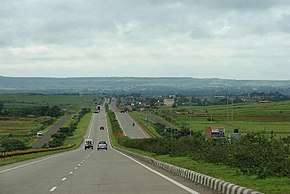
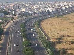
Road transport is vital to India's economy. It enables the country's transportation sector to contribute 4.7 percent towards India’s gross domestic product, in comparison to railways that contributed 1 percent, in 2009–2010. Road transport has gained its importance over the years despite significant barriers and inefficiencies in inter-state freight and passenger movement compared to railways and air. The government of India considers road network as critical to the country's development, social integration and security needs of the country.[21] India's road network carries over 65 percent of its freight and about 85 percent of passenger traffic.[22]
Indian road network is administered by various government authorities, given India's federal form of government. The following table shows the total length of India's road network by type of road as on 31 March 2016.[1]
| Road classification | Authority responsible | Length (km) | Share of network length |
|---|---|---|---|
| National Highways | Ministry of Road Transport and Highways | 101,011 | 1.80 % |
| State Highways | Public Works Department of State/Union Territory | 176,166 | 3.14 % |
| Other PWD roads | Public Works Department of State/Union Territory | 561,940 | 10.03 % |
| Rural roads | Panchayats, JRY and PMGSY | 3,935,337 | 70.23 % |
| Urban roads | Local governments and municipalities | 509,730 | 9.10 % |
| Project roads | Various State/Union territory government departments, and SAIL, NMDC and BRO | 319,109 | 5.70 % |
| Total | N/A | 5,603,293 | 100 % |
Construction
In general, roads in India are primarily bitumen-based macadamised roads. However, a few of the National Highways have concrete roads too. In some locations, such as in Kanpur, British-built concrete roads are still in use. Concrete roads were less popular prior to the 1990s because of low availability of cement then. However, with large supplies of cement in the country and the virtues of concrete roads, they are gaining popularity. Concrete roads are durable, weather-proof and require lower maintenance compared to bituminous roads. Moreover, new concrete pavement technology has developed such as cool pavement, quiet pavement and permeable pavement, which has rendered it more attractive and eco-friendly.
India road building rate has accelerated in recent years and averaged about 12 kilometres (7.5 mi) kilometers per day in 2014-15 to 27 kilometres (17 mi) per day in 2017-18.[23] The country targets to build 40 kilometers of highways every day.[24]
Bharatmala, a centrally-sponsored and funded road and highways project of the Government of India [25] with a target of constructing 83,677 km (51,994 mi)[26] of new highways at an estimated cost of ₹5.35 trillion (US$75 billion) has been started in 2017. Bharatmala Phase -I plans to construct 34,800 km of highways (including remaining projects under NHDP) at an estimated cost of Rs.5,35,000 crore by 2021-22.[27]
Roads
Expressways
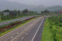
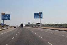
India's first Expressway, the Ahmedabad Vadodara Expressway (also known as National Expressway 1, or the Mahatma Gandhi Expressway) is an expressway connecting the cities of Ahmedabad and Vadodara in the state of Gujarat, India. Expressways make up approximately 1,208 km (751 mi) of India's road network, as of 2013.[28][29] These high-speed roads are four-lane or six-lane, predominantly access controlled. The 165 kilometer Yamuna Expressway, a six-laned controlled-access opened on 9 August 2012.[30] On 21 November 2016, India's longest expressway - the 302 km long six-laned Agra Lucknow Expressway was opened.[31][32]
While the start of several expressway projects such as the Ganga Expressway have been delayed for 3 or more years, because of litigation and bureaucratic procedures. The government has drawn up a target to lay 18,637 kilometre network of brand new expressways by 2022.[33] Most of the existing expressways in India are toll roads.[29]
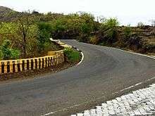
National Highways
_at_Visakhapatnam.jpg)
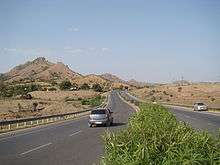
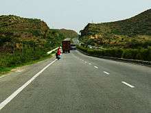
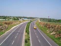
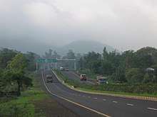
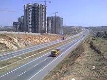
The main highways running through the length and breadth of the country connecting major ports, state capitals, large industrial and tourist centres, etc. National Highways in India are designated as NH followed by the highway number. Indian national highways are further classified based on the width of carriageway of the highway. As of March 2016, India had completed and placed in use 1,01,011 km of national highways.[1]
The National Highways Authority of India (NHAI) is the authority responsible for the development, maintenance and management of National Highways entrusted to it. The NHAI is undertaking the developmental activities under National Highways Development Project (NHDP) in 5 phases. From 2018, the pending projects under NHDP will be subsumed under Bharatmala. The NHAI is also responsible for implementing other projects on National Highways, primarily road connectivity to major ports in India.
| Lanes | Length (km) | Percentage |
|---|---|---|
| Single Lane / Intermediate lane | 20,703 | 20.49% |
| Double lane | 55,603 | 55.05% |
| Four Lane/Six lane/Eight Lane | 24,705 | 24.46% |
| Total | 101,011 | 100% |
State Highways
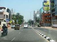
State Governments have the authority and responsibility to build road networks and state highways. Most of the state highways are developed by State PWD. The State Highways provide linkages with the National Highways, district headquarters, important towns, tourist centers and minor ports and carry the traffic along major centers within the state. As of 31 March 2016, the total length of state highways was 176,166 km.[34] As of 31 March 2016 Maharashtra has the largest share in the total length of SH roads (22.14%), followed by Karnataka (11.11%), Gujarat (9.76%), Rajasthan (8.62%) and Tamil Nadu (6.67%).[1]
Independent of the NHDP program, state governments have been implementing a number of state highway projects since 2000. By 2010, state highway projects worth $1.7 billion had been completed, and an additional $11.4 billion worth of projects were under implementation.[35]
District Roads
These are important roads within a district connecting areas of production with markets and connecting them with the State Highways & National Highways and are maintained by the Zila Parishad. District roads are sub-classified into - Major District Roads and Other District Roads. As per the classification of roads broadly the MDRs are to have a minimum width of 15 metres with traffic density of less than 10,000 PCUs but more than 5000 PCUs. It also connects Taluka headquarters and rural areas to District headquarters within the state. As on 31 March 2016, the total length of district roads was approximately 561,940 km of which 94.93% of the total length were surfaced.[1]
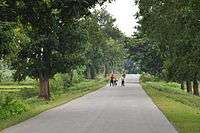
Village Roads
The rural roads in India forms a substantial portion of the Indian road network, constituting 70.23 percent of the total roads in India (as of March 2016). As of March 2016, the percentage of surfaced rural roads to the total rural road length (excluding 9 lakh kilometres of JRY) was 66.15%.[1]
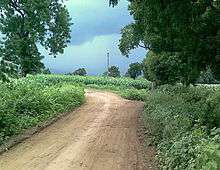
These roads are in poor shape, affecting the rural population's quality of life and Indian farmers' ability to transfer produce to market post-harvest. Over 30 percent of Indian farmers' harvests spoil post-harvest because of the poor infrastructure. Many rural roads are of poor quality, potholed, and unable to withstand the loads of heavy farm equipment. These roads are also far from all-season, good quality 2-lane or 4-lane highways, making economic resource flow slow, and logistical costs between different parts of India one of the highest in the world.
For the development of these rural roads, Pradhan Mantri Gram Sadak Yojana (or "Prime Minister Rural Roads Scheme"), was launched in December 2000 by the Indian government to provide connectivity to unconnected rural habitations. The scheme envisions that these roads will be constructed and maintained by the village panchayats. In some parts of India, where the government has attempted to manage it directly as a local social spending program, this program has produced limited results and no lasting change over 10 years, in either the quality or quantity of rural road network.[37]
In other parts of India, the Pradhan Mantri Gram Sadak Yojana and a sister program named Bharat Nirman (or Build India) have privatized the rural road construction projects and deployed contractors. The effort has aimed to build all-season, single lane, paved asphalted roads that connect India's rural and remote areas. A significant portion of funding for these projects has come from the World Bank and Asian Development Bank.[38] This has produced results, which are presented in the table below.
| Kilometers in 2001 | Kilometers as of May 2011 | Kilometers under construction in 2011 | |
|---|---|---|---|
| Total rural roads | 2.7 million | 3.1 million | 0.1 million |
| Paved, not maintained rural roads | 0.5 million | ||
| Unpaved rural roads | 2.2 million | 1.9 million | |
| Paved, maintained rural roads | 728,871 | 53,634 | |
| New rural roads | 322,900 | 82,743 |
In a 2011 report, The Economist noted the rural road scheme and Mahatma Gandhi National Rural Employment Guarantee to be India's biggest single welfare project, costing over $8 billion a year. Alone, it eats up over 3% of all public spending in India. The report claims Jairam Ramesh, the minister in charge of the central government department administering the program, criticises uneven, patchy implementation of the scheme. He describes wasteful construction of items such as roads that quickly crumble away. The results, in many areas, fall short of the huge sums spent. The funds aimed to employ local villagers through their panchayats is not changing the quality of rural roads, rather ending up in wasteful spending and corrupt government officials’ pockets. The gloomiest estimates suggest two-thirds of allocated scheme funds is being squandered. A review published by the Ministry in September 2011 found that skilled technicians were unavailable at almost every site. There were rules banning the use of machinery or contractors, labour is usually by shovel, resulting in patchy construction of roads, drains, ponds, dams and other assets that are of very poor quality. The government scheme has failed to improve India's awful rural infrastructure. These rural roads get washed away each monsoon, only to be rebuilt, badly, the following year.[39]
Issues


The main roads in India are under huge pressure and in great need of modernisation in order to handle the increased requirements of the Indian economy. In addition to maintenance, the expansion of the network and widening of existing roads is becoming increasingly important. This would then enable the roads to handle increased traffic, and also allow for a corresponding increase in the average movement speed on India's roads.
In 2009, lane capacity was low and only about 16% of India's roads were four lanes or above.[8] A 2007 study found that the congestion on India's highways reduced average truck and bus speeds to 30–40 km/h (19–25 mph); road maintenance was under-funded, and some 40 percent of villages in India lacked access to all-weather roads.[2] While the PMGSY rural road program mentioned above has, by 2011, connected 90 percent of villages identified in 2005 as without access,[36] many remote villages in India were still without access to a single lane, paved road as of May 2011.
The intra-city vehicle speed is one of the lowest in the world. As per a study by Ola Cabs, in 2017, average traffic speed in Bengaluru was 17.2 kmph, while Delhi had the highest traffic speeds in India at 25 kmph.[40] Amongst the other major cities, the average traffic speed in Mumbai was 20.7 kmph, Kolkata (19.2 kmph), Hyderabad (18.5 kmph) and Chennai (18.9 kmph).[40]
The World Health Organization compilation of road network safety data for major economies found India to have the highest number of road fatalities in the World, with 105,000 road-accident caused deaths in 2006.[41] However, adjusted for India's larger population, the accident and fatalities rates are similar to major economies. Over 2004–2007, India had a road fatality rate of 132 deaths per million citizens, compared to 131 deaths per million citizens in the United States. Non-fatal accident rates reported on Indian roads was 429 accidents per million citizens, compared to 412 accidents per million citizens in China, and 1101 accidents per million citizens in the United States. The report notes that not all accidents in India and China are reported and recorded.
The low road densities per 1000 people has created significant congestion and slow speeds on existing roads inside cities. Because of the congestion, the fuel efficiency of the vehicles in India is very low. This increases the overall fuel consumption per equivalent kilometer travelled, besides resulting in heavy pollution since the engines run very inefficiently at such low speeds.[42] Pollutants from poor road network and resultant poor fuel efficiencies include hydrocarbons, NOx, SOx, methane, carbon monoxide and carbon dioxide – all of which cause health problems, adverse climate effects and related environmental damage.
Due to rising prices of petroleum, a non-renewable resource, some have urged the Indian government to focus instead on improving public transport like the Indian Railways and rapid transit systems.[43] Many cities have proposed, or are implementing metros and mass transit systems.
Efforts in India to address issues related to road network
India's recent efforts to build modern highways and improve its road network has made a significant difference in trucking logistics. According to DHL, a global logistics company, the average time to truck shipments from New Delhi to Bengaluru (Bangalore), a 2000+ kilometre journey, had dropped in 2008, to about five days.[44] By 2010, the average time to complete a road trip from New Delhi to Mumbai, a 1400+ kilometer journey, had dropped to about 35 hours. In contrast, a similar journey takes about half the time in China, and one third in European Union countries. In a 2010 report, KPMG – one of the world's largest audit and advisory services company – noted marked improvements in Indian road network and logistics efficiency in recent years.[45] The report also identified the competitive challenges faced by India. Some findings of this report include:
- The average road speed in India has increased to 30–40 kilometers per hour. The worldwide average road speed, which includes China, ranges between 60–80 kilometers per hour.
- Four lane road network in India has increased to 7,000 kilometers.
- Average surface freight costs have dropped to US$0.07 per kilometer. Japan, in comparison, has average surface freight costs of US$0.037 per kilometer.
The KPMG report also notes that India's road network logistics and transportation bottlenecks hinder its GDP growth by one to two percent (US$16 billion – US$32 billion). In India's 2010 per capita income basis, this is equivalent to a loss of about 10 million new jobs every year. Poor rural roads and traffic congestion inside the cities remains a challenge in India. The planned addition of over 12,000 kilometers of expressways in the next 10 years may help address some of such issues. The constraints and issues with Indian road network differ from one state to another. Some states, such as Tamil Nadu, Gujarat, have remarkably better road network than others.
See also
References
- 1 2 3 4 5 6 7 8 9 10 11 12 13 "Basic Road Statistics of India 2015-16". Ministry of Road Transport and Highways. Retrieved 15 January 2018.
- 1 2 3 "India Transport Sector". World Bank.
- ↑ "India en route for grand highways". BBC News.
- ↑ "National Highway Development Project NHDP)". NHAI, Ministry of Roads Transport, Govt of India. March 2017. Archived from the original on 15 May 2016. Retrieved 31 March 2017.
- ↑ Yamuna Expressway to open in April, trial runs on The Times of India
- ↑ The seemingly unending road The Hindu (11 August 2013)
- 1 2 Shobana Chandra. "U.S. Pension Funds May Invest in India Road Projects, Nath Says". Bloomberg L.P.
- 1 2 RN Bhaskar. "Crossing the Chasm". Forbes India.
- ↑ Suman Guha Mozumder. "Kamal Nath on what dogs Indian road projects". Rediff.
- ↑ Indian Highways - Emerging Opportunities Archived 14 July 2014 at the Wayback Machine. Govt of India, Page 15
- ↑ Average lane kilometers per 100,000 equals average kilometers of road per 100,000 multiplied by average number of lanes per road for a country
- ↑ Table - Distribution of density of road network, Ministry of Roads Transport and Highways, Government of India (2013)
- ↑ Taylor (1995). A Star Shall Fall. Collins. ISBN 978-81-7223-066-1.
- ↑ St. John, Ian (2011). The Making of the Raj: India under the East India Company. ABC-CLIO. pp. 83–84. ISBN 9780313097362. Retrieved 15 May 2018.
- ↑ Gupta, Das (2011). Science and Modern India: An Institutional History, c.1784-1947: Project of History of Science, Philosophy and Culture in Indian Civilization, Volume XV, Part 4. Pearson Education India. pp. 454–456. ISBN 9788131753750.
- 1 2 Jagarlamudi, Vishnu. "History of Road Development in India". Scribd. Retrieved 5 May 2018.
- ↑ "Govt declares Golden Quadrilateral complete". The Indian Express. 7 January 2012.
- ↑ "National Highways Development Project Map". National Highways Institute of India. Archived from the original on 4 March 2016. Retrieved 16 January 2018.
- ↑
- ↑ "About NHDP". NHAI. Retrieved 16 January 2018.
- ↑ "Report of Working Group on Road Transport" (PDF). Ministry of Road Transport, Government of India. 2011.
- ↑ "An Overview: Road Network of India". Ministry of Road Transport, Government of India. 2010.
- ↑ "Highway construction grew 20 pct in 2017-18". The Financial Express. 2018-04-04. Retrieved 2018-04-11.
- ↑ "Budget 2018: Allocation for highways set to treble in Modi's term - Times of India". The Times of India. Retrieved 2018-01-15.
- ↑ "Bharat Mala: PM Narendra Modi's planned Rs 14,000 crore road from Gujarat to Mizoram", The Economic Times, New Delhi, 29 April 2015
- ↑ "Ministry proposes construction of 20,000 km of roads under Bharat Mala project", The Economic Times, New Delhi, 9 January 2016
- ↑ "Bharatmala Pariyojana - A Stepping Stone towards New India | National Portal of India". www.india.gov.in. Retrieved 2018-01-18.
- ↑ "India Roads – November 2010" (PDF). IBEF. November 2010.
- 1 2 "Check out India's 13 super expressways". Rediff. July 2011.
- ↑ "Yamuna Expressway from Delhi to Agra opens: 10 facts".
- ↑ http://www.businessinsider.in/Eight-fighter-jets-to-land-on-Agra-Lucknow-expressway/articleshow/55412366.cms
- ↑ http://www.ndtv.com/india-news/8-fighter-jets-at-opening-of-agra-lucknow-expressway-indias-longest-1627999
- ↑ "Project Report on Indian National Expressway Network". Ministry of Road Transport and Highways, Government of India. October 2011.
- ↑ Basic Road Statistics of India 2014 (Report). Ministry of Road Transport & Highways. 23 May 2014. Retrieved 21 June 2014.
- ↑ "Compendium of PPP Projects in State Highways" (PDF). Secretariat for Infrastructure, Govt of India. June 2010. Archived from the original (PDF) on 25 April 2012.
- 1 2 3 "Pradhan Mantri Gram Sadak Yojana (PMGSY) including Bharat Nirman (Rural Connectivity) Program Review". Ministry of Rural Development, Government of India. July 2011.
- ↑ "India's boom bypasses the poor". The Wall Street Journal. 29 April 2011.
- ↑ "New all weather roads boost rural incomes, India". The World Bank. 2009.
- ↑ "Indian rural welfare: Digging holes". The Economist. 5 November 2011.
- 1 2 "Surprise Surprise, Bengaluru traffic speed slowest says study by Ola". The News Minute. 2017-12-30. Retrieved 2018-04-11.
- ↑ "Global Status Report on Road Safety" (PDF). World Health Organization. 2009.
- ↑ John Pucher; Nisha Korattyswaropam; Neha Mittal; Neenu Ittyerah. "Urban transport crisis in India" (PDF). Archived from the original (PDF) on 14 March 2007.
- ↑ Minister of Road Transport and Highways for India
- ↑ "Logistics in India". DHL. 2008. Archived from the original on 24 July 2012.
- ↑ "Logistics in India, part 1 (A 3 part series)" (PDF). KPMG. 2010.
External links
| Wikimedia Commons has media related to Roads in India. |