Nagpur division
| Nagpur division | |
|---|---|
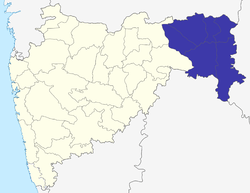 Location of Nagpur Division in Maharashtra | |
| Coordinates: 21°09′36″N 79°04′48″E / 21.16000°N 79.08000°ECoordinates: 21°09′36″N 79°04′48″E / 21.16000°N 79.08000°E | |
| Country | India |
| State | Maharashtra |
| Districts | 1. Bhandara, 2. Chandrapur, 3. Gadchiroli, 4. Gondia, 5. Nagpur, 6. Wardha |
| Area | |
| • Total | 51,336 km2 (19,821 sq mi) |
| • Under irrigation | 4,820 km2 (1,860 sq mi) |
| Population (2001) | |
| • Total | 10,665,939 |
| Literacy | 75.90% |
Nagpur Division is one of six administrative divisions of Maharashtra State in India. Nagpur is the most eastern division in the state, with an administrative headquarters in the city of Nagpur. It covers 51,336 km² (19,821 mi²). The Amravati and Nagpur divisions make up the region of Vidarbha.
History
Nagpur Division was created in 1861, when the Central Provinces administrative division of British India was created by merging the Nagpur Province and the Saugor and Nerbudda Territories. Before 1861, Nagpur Division had been part of Nagpur Province, which had been created after the Nagpur kingdom was annexed by the British in 1853 by means of the Doctrine of lapse.[1] The British Nagpur Division included the current districts as well as Balaghat District, currently part of Madhya Pradesh.[2]
After Indian Independence, The Central Provinces and Berar (Amravati Division) became the new state of Madhya Pradesh. The Indian states were reorganised along linguistic lines in 1956, and on 1 November Nagpur and Amravati Divisions were transferred to Bombay State, while Balaghat District remained in Madhya Pradesh. The Marathi-speaking portion of Bombay State became Maharashtra State in 1960.
Administration, Districts and Talukas
Nagpur Division has 6 districts. Following table shows the districts of Nagpur Division and their tahsils :
| Name of Division (Headquarter) | Sr. No. | Districts | Administration | Sub-Division | Taluka | Source |
|---|---|---|---|---|---|---|
| Nagpur Division HQ=Nagpur Districts=6 SubDivisions=31 Talukas=64 |
1. | Bhandara district | HQ-Bhandara Sub-Divisions-3 Taluka-7 |
Bhandara | District website | |
| Tumsar | ||||||
| Sakoli | ||||||
| 2. | Chandrapur District | HQ-Chandrapur Sub-Divisions-8 Taluka-15 |
Chandrapur | District website | ||
| Ballarpur | ||||||
| Mul | ||||||
| Gondpimpri | ||||||
| Warora | ||||||
| Chimur | ||||||
| Rajura | ||||||
| Bramhapuri | ||||||
| 3. | Gadchiroli District | HQ-Gadchiroli Sub-Divisions-6 Taluka-12 |
Gadchiroli | District website | ||
| Chamorshi | ||||||
| Aheri | ||||||
| Etapalli | ||||||
| Desaiganj/(Wadasa) | ||||||
| Kurkheda | ||||||
| 4. | Gondia District | HQ-Gondia Sub-Divisions-4 Taluka-8 |
Gondia | District website | ||
| Tiroda | ||||||
| Deori | ||||||
| Arjuni Morgaon | ||||||
| 5. | Nagpur District | HQ-Nagpur Sub-Divisions-7 Taluka-14 |
Nagpur City | District website | ||
| Nagpur Rural |
| |||||
| Mauda | ||||||
| Umred | ||||||
| Ramtek | ||||||
| Saoner | ||||||
| Katol | ||||||
| 6. | Wardha District | HQ-Wardha Sub-Divisions-3 Taluka-8 |
Wardha | District website | ||
| Arvi | ||||||
| Hinganghat | ||||||
| Total Districts= 6 | Total Sub-Divisions = 31 | Total Talukas = 64 | ||||
See also
References
- ↑ History; Gazetteer, 1966
- ↑ Hunter, William Wilson, Sir, et al. (1908). Imperial Gazetteer of India, 1908-1931; Clarendon Press, Oxford
| Topics | |||||||||||||
|---|---|---|---|---|---|---|---|---|---|---|---|---|---|
| Regions | |||||||||||||
| Divisions and Districts |
| ||||||||||||
| Million-plus cities in Maharashtra | |||||||||||||
| Other cities with municipal corporations | |||||||||||||
Portal: Maharashtra | |||||||||||||