Collegeville, Minnesota
| Collegeville, Minnesota | |
|---|---|
| Unincorporated community | |
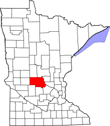
 Collegeville, Minnesota Location of the community of Collegeville within St. Wendel Township, Stearns County  Collegeville, Minnesota Collegeville, Minnesota (the US) | |
| Coordinates: 45°35′40″N 94°21′47″W / 45.59444°N 94.36306°WCoordinates: 45°35′40″N 94°21′47″W / 45.59444°N 94.36306°W | |
| Country | United States |
| State | Minnesota |
| County | Stearns |
| Township | St. Wendel Township |
| Elevation | 1,096 ft (334 m) |
| Time zone | UTC-6 (Central (CST)) |
| • Summer (DST) | UTC-5 (CDT) |
| ZIP code | 56321 and 56374 |
| Area code(s) | 320 |
| GNIS feature ID | 641398[1] |
Collegeville is an unincorporated community in St. Wendel Township, Stearns County, Minnesota, United States, near St. Joseph. The community is located near the junction of Collegeville Road and Old Collegeville Road. Nearby is Saint John's Abbey, a large Benedictine monastery.[2] Stearns County Road 159 serves as a main route for the community. Interstate 94 is nearby.
Geography
Collegeville is located within section 32 of St. Wendel Township. Collegeville Township lies to the southwest.
History
The community was named for Saint John's University.[3]
References
- ↑ "Collegeville, Minnesota". Geographic Names Information System. United States Geological Survey.
- ↑ Graham, Regina (27 November 2015). "Monks accused of FIVE DECADES of sexual abuse of children at Minnesota abbey - and one is alleged to have had 200 victims". Daily Mail.
- ↑ Upham, Warren (1920). Minnesota Geographic Names: Their Origin and Historic Significance. Minnesota Historical Society. p. 523.
Municipalities and communities of Stearns County, Minnesota, United States | ||
|---|---|---|
| Cities |
|  |
| Townships |
| |
| CDP | ||
| Unincorporated communities | ||
| Ghost towns/Neighborhoods | ||
| Footnotes | ‡This populated place also has portions in an adjacent county or counties | |
This article is issued from
Wikipedia.
The text is licensed under Creative Commons - Attribution - Sharealike.
Additional terms may apply for the media files.