Fairhaven, Minnesota
| Fairhaven, Minnesota | |
|---|---|
| Census-designated place (CDP) and Unincorporated community | |
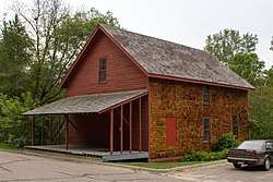 The 1867 Fair Haven Flour Mill | |
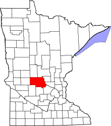
 Fairhaven, Minnesota Location of the community of Fairhaven within Fair Haven Township, Stearns County | |
| Coordinates: 45°19′18″N 94°12′41″W / 45.32167°N 94.21139°WCoordinates: 45°19′18″N 94°12′41″W / 45.32167°N 94.21139°W | |
| Country | United States |
| State | Minnesota |
| County | Stearns |
| Township | Fair Haven Township |
| Area[1] | |
| • Total | 2.055 sq mi (5.32 km2) |
| • Land | 1.908 sq mi (4.94 km2) |
| • Water | 0.147 sq mi (0.38 km2) |
| Elevation | 1,086 ft (331 m) |
| Population (2010)[2] | |
| • Total | 358 |
| • Density | 170/sq mi (67/km2) |
| Time zone | UTC-6 (Central (CST)) |
| • Summer (DST) | UTC-5 (CDT) |
| ZIP code | 55382 |
| Area code(s) | 320 |
| GNIS feature ID | 643500[3] |
Fairhaven is an unincorporated community and census-designated place (CDP) in Fair Haven Township, Stearns County, Minnesota, United States. Its population was 358 as of the 2010 census.[2]
The community is located near the junction of Stearns County Roads 7 and 44. Nearby places include Kimball, South Haven, Clearwater, and St. Augusta. Stearns County Road 45 is also in the immediate area.
Fairhaven contains one property listed on the National Register of Historic Places: the 1867 Fair Haven Flour Mill.[4]
References
- ↑ "US Gazetteer files: 2010, 2000, and 1990". United States Census Bureau. 2011-02-12. Retrieved 2011-04-23.
- 1 2 "American FactFinder". United States Census Bureau. Archived from the original on 2013-09-11. Retrieved 2011-05-14.
- ↑ "Fairhaven, Minnesota". Geographic Names Information System. United States Geological Survey.
- ↑ "Minnesota National Register Properties Database". Minnesota Historical Society. 2009. Retrieved 2018-06-12.
Municipalities and communities of Stearns County, Minnesota, United States | ||
|---|---|---|
| Cities |
|  |
| Townships |
| |
| CDP | ||
| Unincorporated communities | ||
| Ghost towns/Neighborhoods | ||
| Footnotes | ‡This populated place also has portions in an adjacent county or counties | |
| Core City |  | ||||
|---|---|---|---|---|---|
| Surrounding communities |
| ||||
| Counties | |||||
‡ indicates that it is partially in the metropolitan area. § indicates a CDP | |||||
This article is issued from
Wikipedia.
The text is licensed under Creative Commons - Attribution - Sharealike.
Additional terms may apply for the media files.